
![(Notherneastern Sheet) [Bancroft's Map of the Pacific States]](/map/small/54925.jpg)
Engraved Proof Sheet. "Bancroft's, in scope, was probably the most important map yet produced by a publisher of the Pacific coast." - Streeter (TMW 1061) Engraved proof of the 1867 edition of H.H. Bancroft's Map of the Pacific States. The detail in...
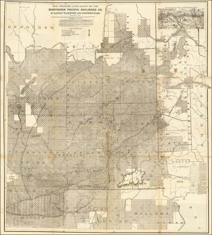
Rare large lithographed folding map showing land ownership opportunities in eastern Washington State and western Idaho, published to promote the lands owned and serviced by the Northern Pacific Railroad. The map is focused on the the growing...
![[Central Idaho & Eastern Oregon Letter Sheet Map] This Is Not A Map Of The World . . . The Weiser Commercial Club, Weiser, Idaho.](/map/small/40601.jpg)
Interesting promotional letter sheet map of the area around Weiser, Idaho, with a letter on the verso referencing the Weiser Irrigation District -- Washington County, Idaho. The map is centered on Weiser, Idaho, and extends southeast to Boise, Idaho,...
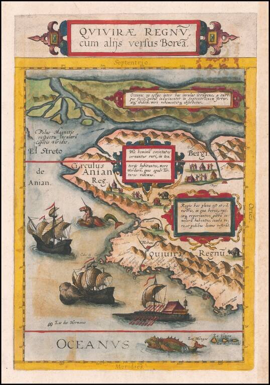
The Benevento Copy. The Earliest Printed Map of the Northwest Coast of North America Fine old color example of this rare, important map depicting the west coast of North America, derived from Plancius's world map of 1592. De Jode's map is one of the...
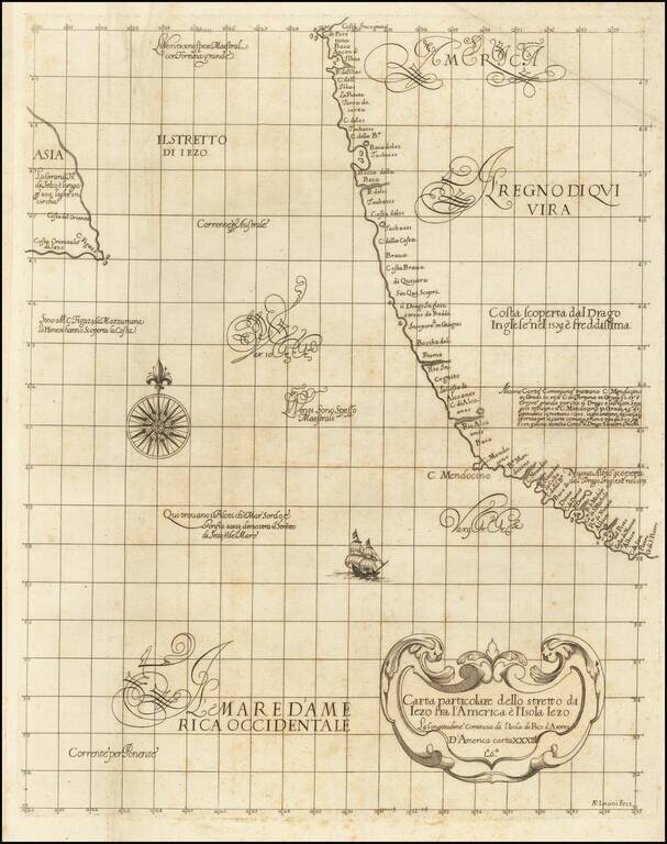
"The First Printed Sea Chart of the Northwest Coast of North America" (San Francisco to Vancouver Island) Rare early sea chart of the Pacific Northwest, from Sir Robert Dudley's Dell'Arcano del Mare. The chart shows all of the American Pacific coast...
![Wm. T. Coleman & Co.'s Map of the State of California [and] Wm. T Coleman& Co's. Skeleton Map of Columbia River Canneries, Showing Their Location.](/map/small/69974.jpg)
Exceptional Chromolithographic Promotional Maps Rare promotional maps of California the Columbia River Basin one verso, promoting the shipping business of pioneer California Businessman William Tell Coleman. The California map locates several...
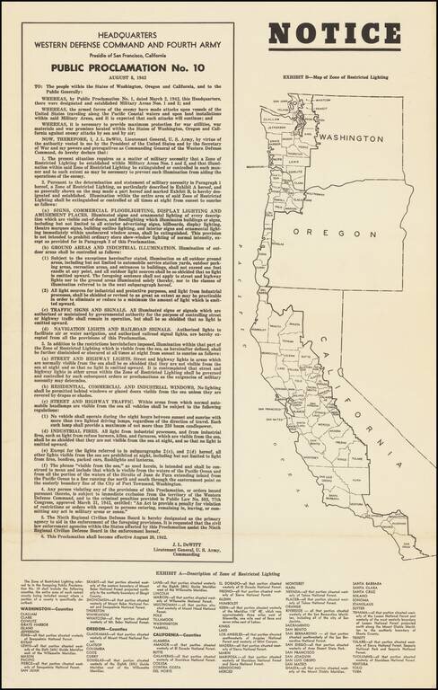
Lights Out Across the Pacific Coast. World War II broadside declaring the institution of Public Proclamation No. 10, which heavily controlled the use of artificial lighting on the West Coast, so as to inhibit nighttime attacks by Japanese warships and...
![[WWII War Bonds] As Bond Away Finishes Its Tour](/map/small/63461.jpg)
Fourth Air Force Aviation Engineers Camouflage Bond Show -- Northern California 1944 Rare promotional pamphlet and map, supporting the sale of bonds to support the war effort. Issued in the winter of 1944, the map illustrates the different places...
![СѢВЕРНАЯ АМЕРИКА въ Санктпетербургъ. 1788. [North America (published) in St. Petersburg. 1788.]](/map/small/56512.jpg)
One of the First Russian Maps of the United States. Stating the Pacific Northwest was "acquired by Bering [and] Chirikov [in] 1741". Superb, separately issued engraved map of North America, published in Saint Petersburg in 1788. The map represents...
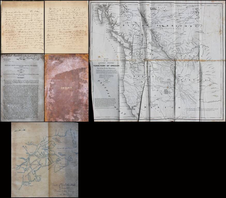
Interesting small archive relating to the Oregon Question, Involving Significant British and American Characters. The present offering consists of the following A letter from Sir George Augustus Wetherall (Deputy Adjutant General of Canada) to Sir...
![Map of Oregon, Washington, Idaho and part of Montana [Early appearance of Montana]](/map/small/70803.jpg)
Interesting early map of the Northwest, hand-colored by counties or territories. The map is copyright-dated 1860, and has counties in eastern Oregon but not in Idaho or Montana. The existence of Montana dates the publication to 1864 or later. A fine...
![[Pacific Northwest] Cape Mendocino to Vancouver Id. From Cape Flattery Southward, From The United States to 1886, with corrections and additions to 1920 . . .](/map/small/70829.jpg)
This is a detailed navigational chart showing the whole of the Pacific Northwest, stretching from northern California to southern British Columbia. Many minor coastal and riverine towns are labeled, including some that would become major cities, such...
![Reconnaissance of the Western Coast of the United States From Monterey To The Columbia River in three sheets. Sheet No. 3. [Columbia River to Umpquah River]](/map/small/42733.jpg)
Interesting early coastal chart of the Oregon Coastline, the northern most of 3 charts published to cover the region by the US Coast Survey.
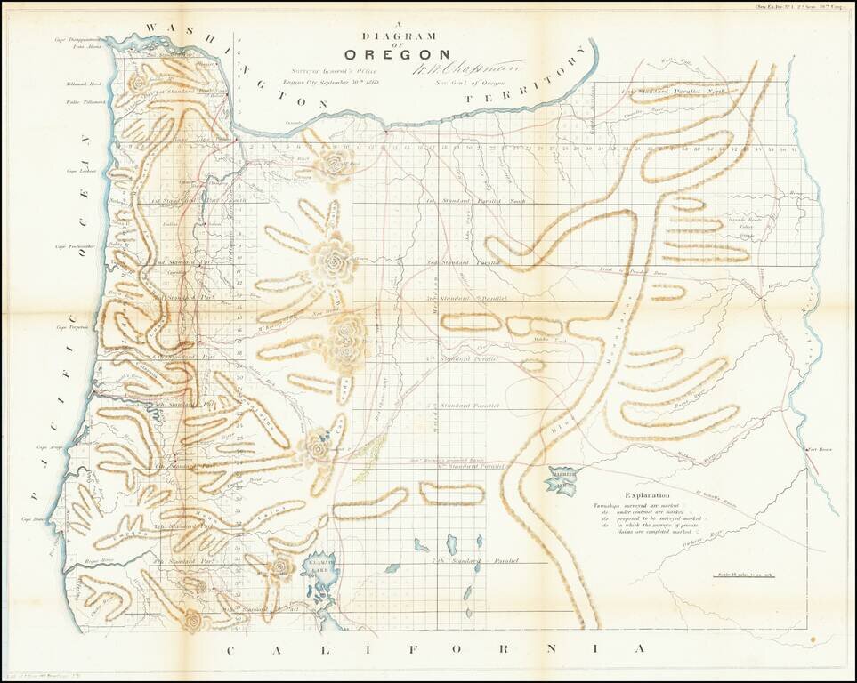
One of the earliest obtainable maps showing the progress of the public surveys in the State of Oregon. The map includes townships surveyed to 1863, towns, early roads, topographical details, Fort Boise, Mountains and other details.
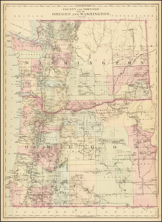
Detailed map of Washington and Oregon, which appeared in a late edition of Mitchell's General Atlas, pubished by William Bradley. The map is colored by counties and showing towns, roads, railroads, rivers, lakes, and a host of other details. SA...
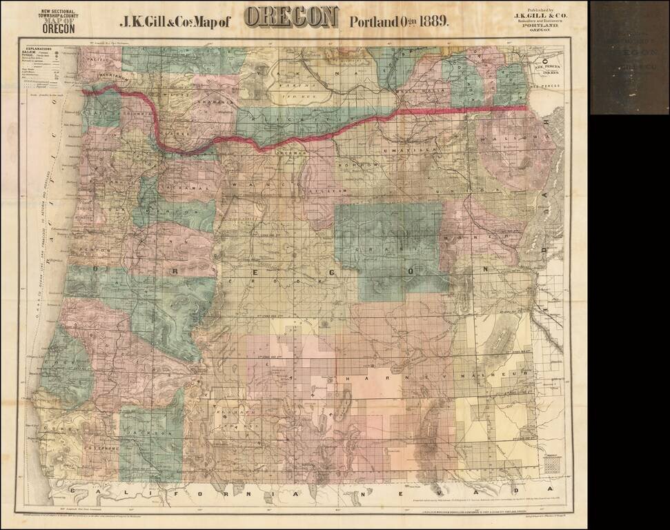
The Most Popular Separately Published Map of Oregon of Its Time -- Portland Publisher Scarce separately issued map of Oregon by J.K. Gill, the leading local seller of books and stationary in Portland at the time. Gill's maps were frequently updated....