The Arrowsmiths were a cartographic dynasty which operated from the late-eighteenth century to the mid-nineteenth. The family business was founded by Aaron Arrowsmith (1750-1823), who was renowned for carefully prepared and meticulously updated maps, globes, and charts. He created many maps that covered multiple sheets and which were massive in total size. His spare yet exacting style was recognized around the world and mapmakers from other countries, especially the young country of the United States, sought his maps and charts as exemplars for their own work.
Aaron Arrowsmith was born in County Durham in 1750. He came to London for work around 1770, where he found employment as a surveyor for the city’s mapmakers. By 1790, he had set up his own shop which specialized in general charts. Arrowsmith had five premises in his career, most of which were located on or near Soho Square, a neighborhood the led him to rub shoulders with the likes of Joseph Banks, the naturalist, and Matthew Flinders, the hydrographer.
Through his business ties and employment at the Hydrographic Office, Arrowsmith made other important relationships with Alexander Dalrymple, the Hudson’s Bay Company, and others entities. In 1810 he became Hydrographer to the Prince of Wales and, in 1820, Hydrographer to the King.
Aaron Arrowsmith died in 1823, whereby the business and title of Hydrographer to the King passed to his sons, Aaron and Samuel, and, later, his nephew, John. Aaron Jr. (1802-1854) was a founder member of the Royal Geographical Society (RGS) and left the family business in 1832; instead, he enrolled at Oxford to study to become a minister. Samuel (1805-1839) joined Aaron as a partner in the business and they traded together until Aaron left for the ministry. Samuel died at age 34 in 1839; his brother presided over his funeral. The remaining stock and copper plates were bought at auction by John Arrowsmith, their cousin.
John (1790-1873) operated his own independent business after his uncle, Aaron Arrowsmith Sr., died. After 1839, John moved into the Soho premises of his uncle and cousins. John enjoyed considerable recognition in the geography and exploration community. Like Aaron Jr., John was a founder member of the RGS and would serve as its unofficial cartographer for 43 years. Several geographical features in Australia and Canada are named after him. He carried the title Hydrographer to Queen Victoria. He died in 1873 and the majority of his stock was eventually bought by Edward Stanford, who co-founded Stanford’s map shop, which is still open in Covent Garden, London today.
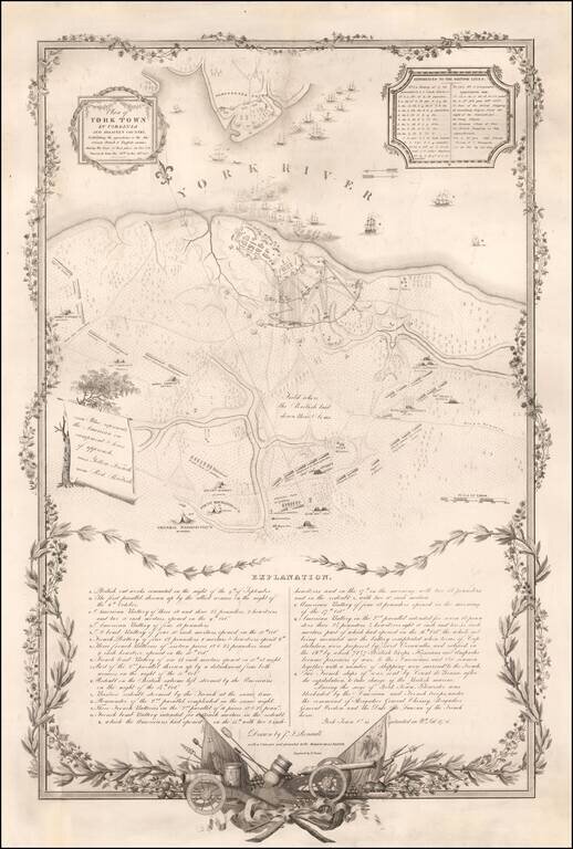
Revolutionary War Battle Plan Published to Commemorate the Marquis De Lafayette's Return To America in 1825 Rare plan of the siege of Yorktown, issued on the occasion of Lafayette's triumphal 1825 visit to America. Drawn by John Francis Renault, a...
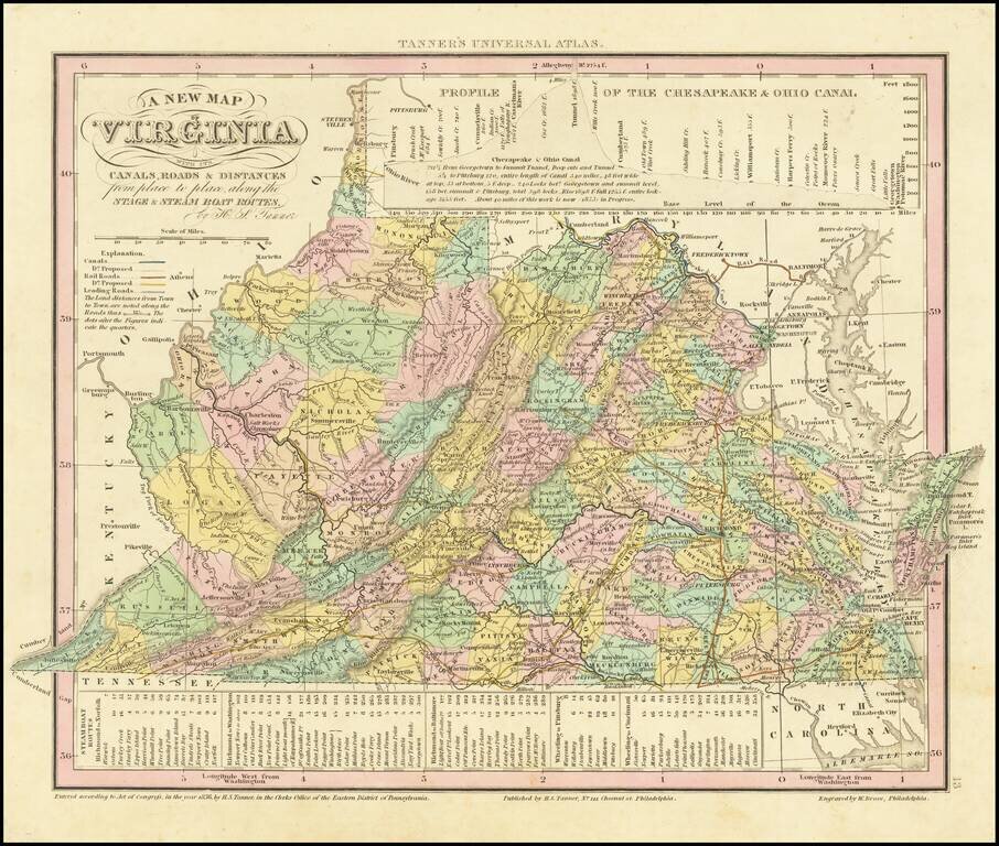
Detailed map of Virginia, from Tanner's Universal Atlas. Detailed and interesting map, hand colored by county and showing towns, rivers, bays, lakes, railroads, roads, distances, etc. Tables of Steam Boat routes and distances. Population Table by...
![Mexico & Guatemala [Showing pre-Republic of Texas (Coahuila and Texas)]](/map/small/71256.jpg)
Detailed map of Mexico and the Southwest, featuring Texas and Coahuila, on the eve of Texas Independence. The Austins Colony appears prominently in Texas, along with Austin's Grant, Washington, Houston, Goliad and a number of other early settlements....
![[Republic of Texas] Map of Texas From the most recent authorities . . .](/map/small/32223.jpg)
Nice example of Henry Schenk Tanner's map of the Republic of Texas, issued in Tanner's Universal Atlas. The present example is the rare first state of Tanner's 1845 map of the Republic, pre-dating, the addition of a number of Texas Counties formed in...
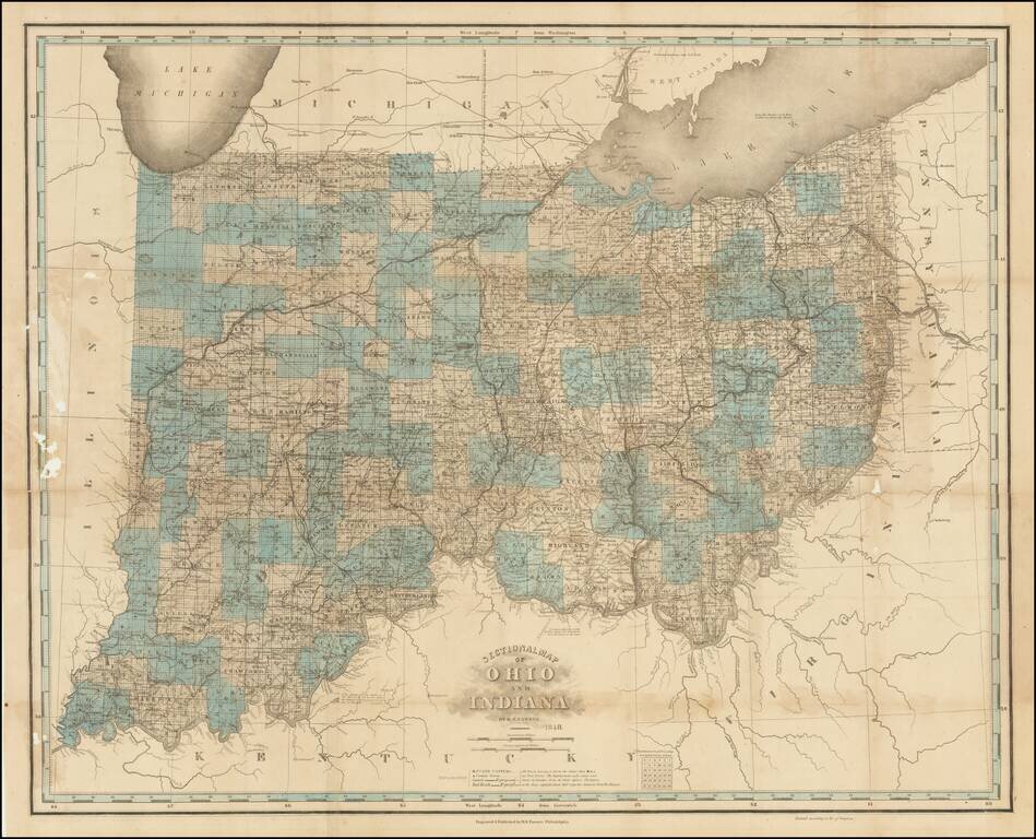
Unrecorded Final State. Extremely rare 10th state (and presumed final) state of one of the best 19th-century maps of Ohio and Indiana. The map was initially issued in 1819, though here that information has been obliterated from the imprint line in...
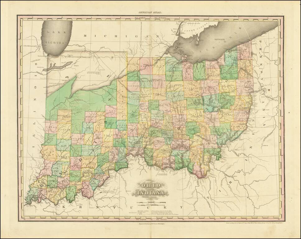
A nice example of this important early map of Indiana and Ohio, published by Henry Schenk Tanner. The present example is the 3rd state of the map, most notable for the addition of Randolph County and a massive Kankakee Pond, plus a new Indian Village...
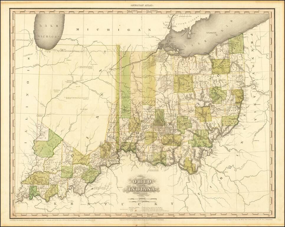
A nice example of this important early map of Indiana and Ohio, published by Henry Schenk Tanner. The present example is the 1st state of the map, most notable for the addition of Randolph County and a massive Kankakee Pond, plus a new Indian Village...
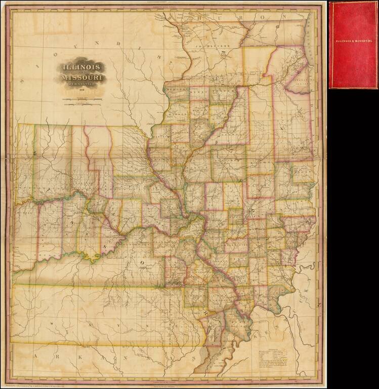
Significantly revised and updated version of HS Tanner's large format map of Missouri and Illinois Territories, first issued in 1821. The map includes remarkable detail where there had been relatively little detailed cartographic work to date. The...
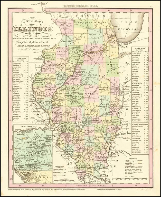
Marvelous example of Tanner's map of Illinois, hand colored by counties. Shows canals, railroads, towns, roads, distances, and tables with steam boat routes and distances. The county configuations are largely complete. Inset of the Lead Region of...
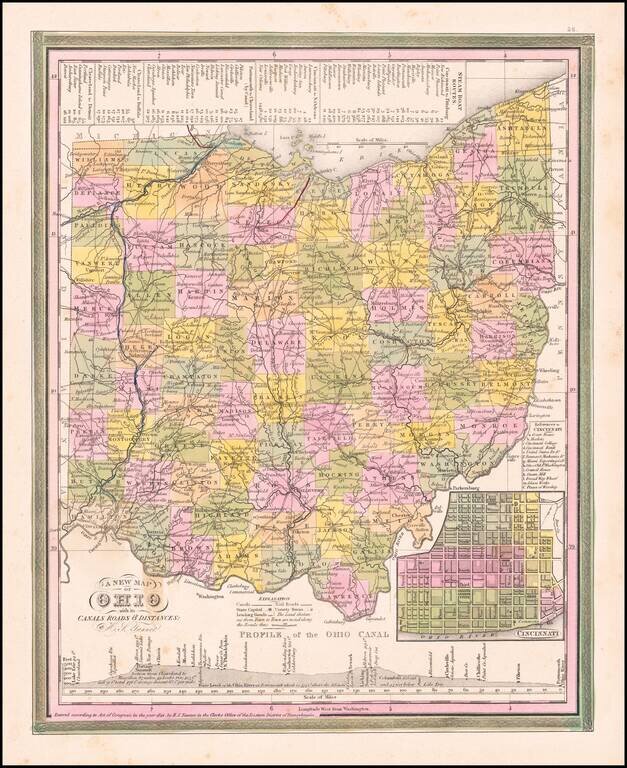
Nice example of Tanner's map of Ohio, hand colored by county, showing roads, canals, towns, steamship routes and other interesting details. An inset shows the city plan for Cincinnati and a profile of the Ohio Canal. One spot in the border at the...
![[Michigan Territory] A New Map of Michigan with its Canals, Roads & Distances by H.S. Tanner](/map/small/68804.jpg)
Michigan 4 Years After Statehood Scarce early example of Tanner's map of Michigan Territory, with interesting early/primitive counties, Indian Lands, etc. Some of the northern counties are not yet completely formed.
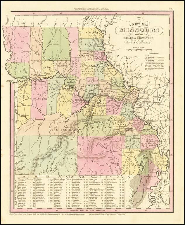
Detailed map of Missouri from Tanner's New Universal Atlas. Hand colored by county and showing towns, rivers, lakes, railroads, roads, etc. Table of Steam Boat routes and distances. Includes a number of ovesized counties, including Barry, Taney,...
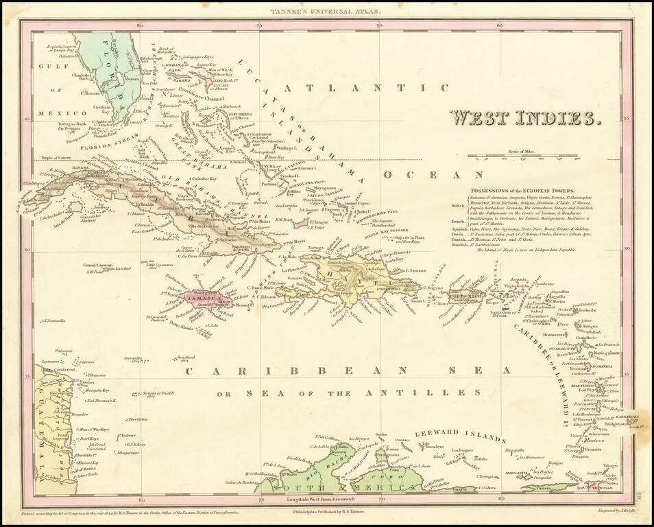
Detailed and attractive map of the southern portion of Florida and the Caribbean from the first edition of Tanner's Universal Atlas. The map shows the various European Powers possessions, including Spanish, British, French, Dutch, Danish and Swedish,...
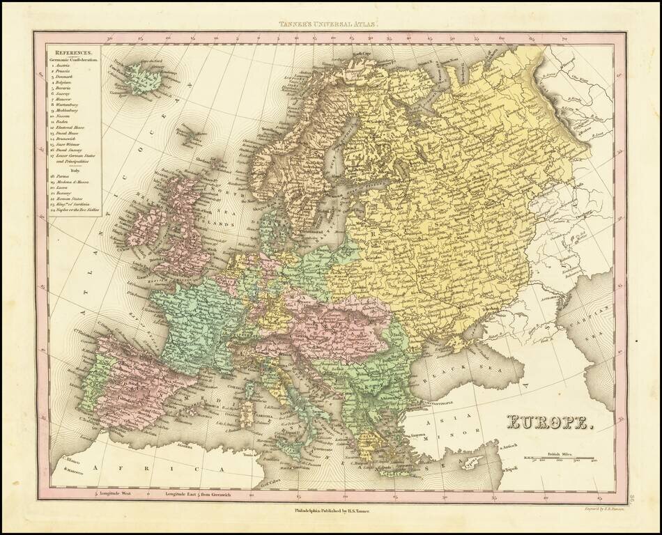
Detailed map of Europe colored by countries. Large key shows the various parts of the Germanic Confederation and Italy. This map is from an early edition of Tanner's New Universal Atlas, first issued in 1834. The Atlas would become the most popular...
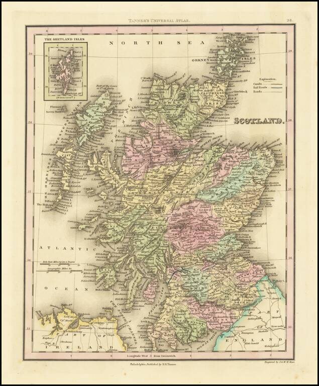
Fine example of Henry Schenk Tanner's map of Scotland, published in Philadelphia. The map is hand colored by counties and showing towns, rivers, lakes, railroads, roads, etc. Tanner was perhaps the single most important American commercial mapmaker...
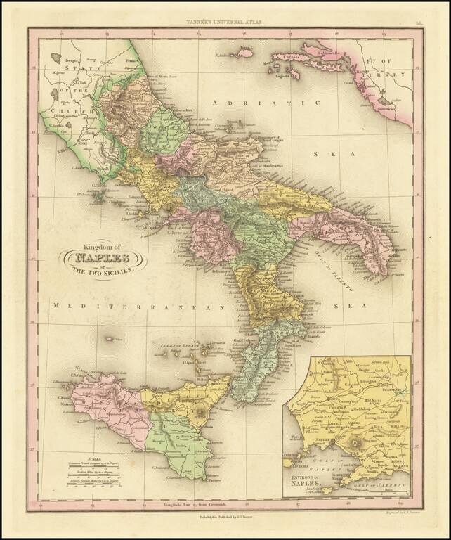
Interesting map of Naples and Sicily, divided into regions. Shows towns, rivers, roads, lakes, mountains, volcanoes, islands, bays, etc. Large inset of the Naples region. This map is from an early edition of Tanner's New Universal Atlas, first issued...