logo

1836. A New Map Of Illinois with its Proposed Canals, Roads & Distances from Place to Place along Stage & Steam Boat Routes. by H.S. Tanner

  • A New Map Of Illinois with its Proposed Canals, Roads & Distances from Place to Place along Stage & Steam Boat Routes.  by H.S. Tanner

A New Map Of Illinois with its Proposed Canals, Roads & Distances from Place to Place along Stage & Steam Boat Routes. by H.S. Tanner information:

Year of creation: 
Resolution size (pixels): 
 7131x8733 px
Disk Size: 
 14.9709MiB
Number of pages: 
 1
Place: 
 Philadelphia
Author: 

Print information. Print size (Width x height in inches):
Printing at 72 dpi 
  99.04 х 121.29
Printing at 150 dpi 
 47.54 х 58.22
Printing at 300 dpi 
 23.77 х 29.11

An example of detailing the file of this map of in a printable high-resolution:

Click to open in high resolution (open in new tab).
Attention! this is just the central piece (central area 960x960 px) of the map file!
This is an example, so that you can see and study the level of detail of a given map. The entire Map will be fully available after payment!

A New Map Of Illinois with its Proposed Canals, Roads & Distances from Place to Place along Stage & Steam Boat Routes.  by H.S. Tanner

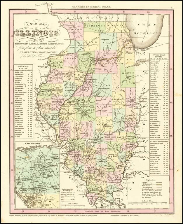
Marvelous example of Tanner's map of Illinois, hand colored by counties.

Shows canals, railroads, towns, roads, distances, and tables with steam boat routes and distances. The county configuations are largely complete. Inset of the Lead Region of Wisconsin and Northwestern Illinois are shown in a large inset.

Tanner's New Universal Atlas became the standard work in the Industry until Tanner sold the rights to the atlas in 1846 to SA Mitchell. The early editions are well regarded for the high quality paper and fine engraving, comparable to the American Atlas. Tanner's Universal Atlas is now rare on the market and the separate maps are now increasingly difficult to obtain.


Special conditions for students!

If you are a student, write to us in telegram: @antiquemaps and indicate what material you need and for what work you need a map in high detail. We are ready to provide material on special terms. For students only!

Item information:

Year of creation:
Size:
7131x8733 px
Disk:
14.9709MiB
Number of pages:
1
Place:
Philadelphia
Author:
Henry Schenk Tanner.
$14.99

Related item