
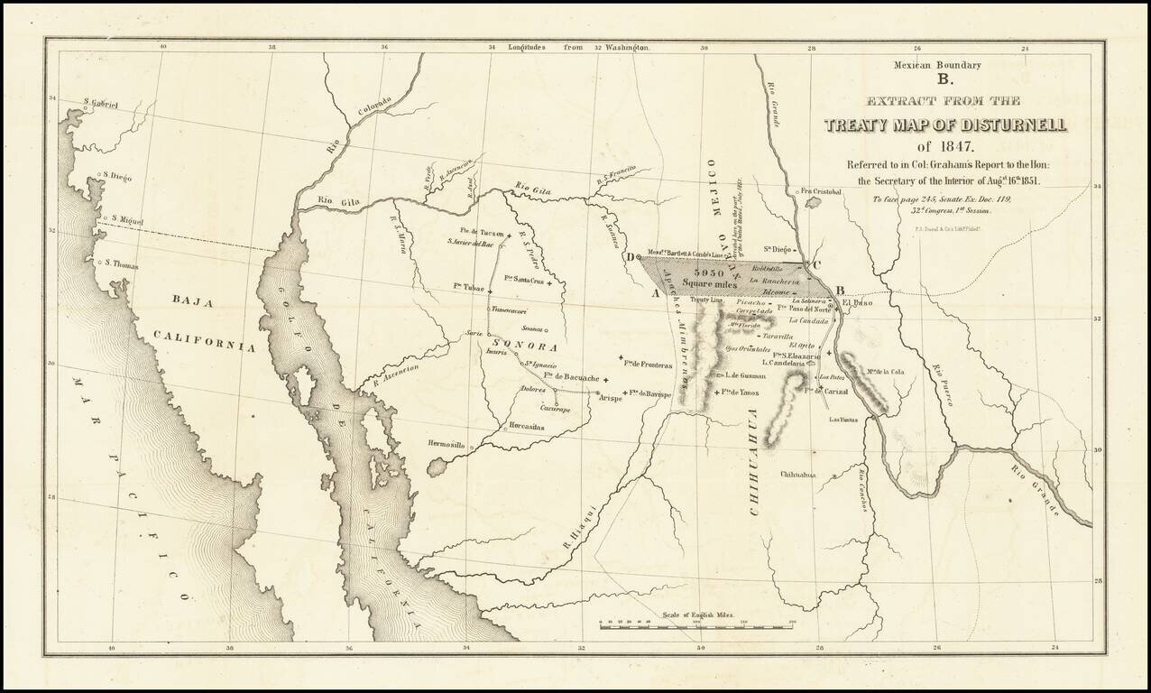
Important map illustrating the region between the Rio Grande and the Colorado River, with forts and towns marked, mainly intended to illustrate the error made by Bartlett in setting the line from the Rio Grande to the Continental Divide too far north,...
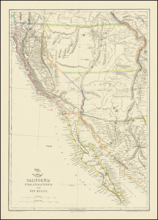
Nice example of the Ettling / Weekly Dispatch map of California and the Southwest, one of first atlas maps published in Europe to focus on the Territories of Utah and New Mexico. The map includes an excellent post Gadsden Purchase treatment of...
![Map of Mexico, Central America, and the West Indies [Insets of Bermuda, Cuba, Jamaica and Panama Railroad]](/map/small/51948.jpg)
Attractive map of Mexico, the Caribbean and the Gulf Coast, published by SA Mitchell Jr. Includes large insets of Cuba, Bermuda, Jamaica, and the Isthmus of Panama and a small inset of Jamaica. Shows shipping routes from New Orleans to points...
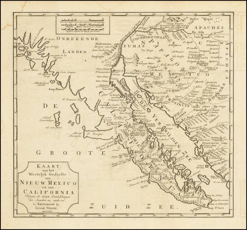
One of the Earliest Obtainable Maps of Southern California and Baja California Fine old color example of this early map of Baja California and parts of Alta California, Arizona and Sonora. Isaac Tirion's map of Baja California is one of the best...
![[Southern California, Arizona, Baja & Sonora] Amer. Sep. No. 53 Partie De La Vielle Californie](/map/small/47400.jpg)
Early mapping of Southern California, southwestern Arizona, northern Baja California and Sonora, published in Brussels. The California Coastline is shown from San Juan Capistrano in the north to the Bay of San Francisco in Baja Norte, centered on San...
![[California Coastline] Carta particolare della America e parte maestrale dal C: di Cedros… D'America carta XXXII](/map/small/58075.jpg)
The Earliest Obtainable Sea Chart of the Coastline of California Fine example of the first edition of Robert Dudley's chart of the California Coastline, the earliest obtainable chart of the region and the first printed map to note the prevailing...
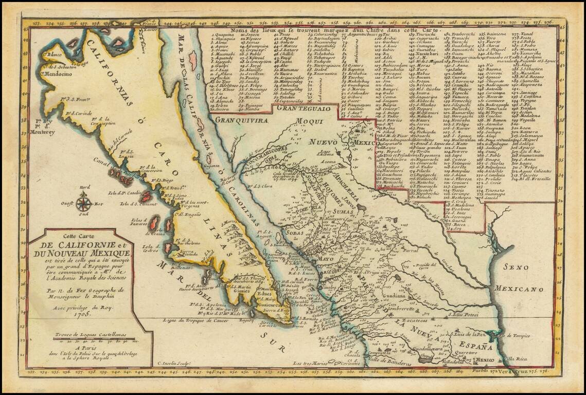
De Fer’s Map of the Southwest Based Upon the Earliest Reports of Father Kino -- One of the Few Regional Maps to Show the Island of California Scarce second state of De Fer's map of California, bearing the date 1705. This is one of a select few...
![[The 5 Californias] Carte De La Californie Suivant 1. La Carte manuscrite de l'Americque de Mathieu Neron Pecci olen dressee a Florence en 1604, 2. Sanson 1656 . . .](/map/small/67157.jpg)
Survey of the Fine Early Maps of California A historically important depiction of the 5 most influential cartographic depictions of California, showing the evolution of how California was mapped between 1604 and 1767. The earliest map is (upper...
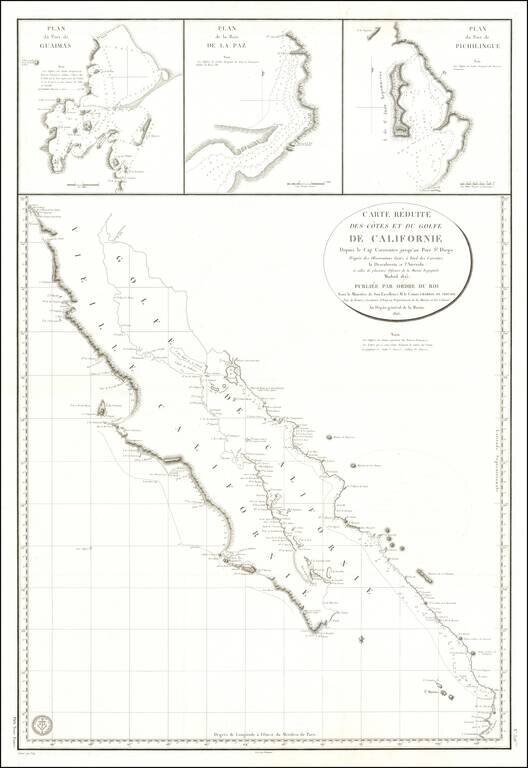
Baja California Immediately After Mexican Independence Rare large scale map Baja California, prepared by the French Government, based upon a Spanish Chart published the preceding year. In addition to all of Baja California, the map depicts the area...
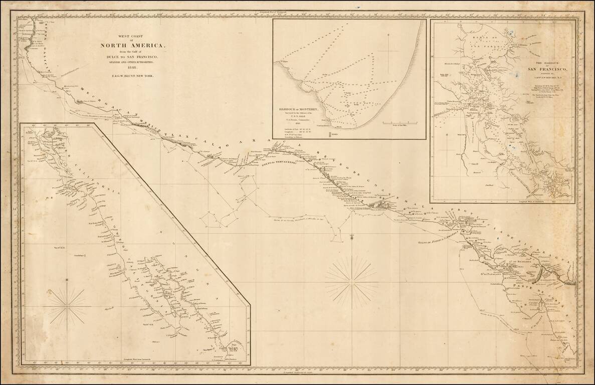
Rare sea chart of California, Mexico and Central American coastline, showing the southern sea route to San Francisco printed on the eve of the California Gold Rush. This fine chart depicts the length of the Pacific Coast of North and Central America,...
![Chart of the Coast of California from San Blas to San Francisco Drawn chiefly from the Spanish Surveys, the Charts of Vancouver &c. the whole much improved by recent observations made by English and French Naval Officers . . . 1854 [Additions to 1862]](/map/small/58999.jpg)
An Early Sea Chart of the Coast of California with Manuscript Annotations From Early Use at Sea Striking large scale blue-backed sea chart of the California, significantly revised and improved from the 1849 edition. Visually striking and rare sea...
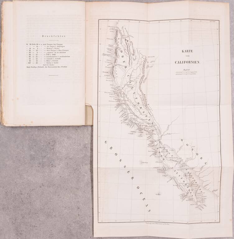
With a Rare 1849 Map of California. This early German description of California was published to take advantage of the keen European interest in the California gold discovery. Like many such publications, the author drew heavily upon previous travel...
![[Lower California]](/map/small/25667.jpg)
Early map of Baja California, printed in connection with an early Government exploration of the region.
![(California-Mexico Border Survey) Datos de los trabajos astronómicos y topográficos. [bound with:] Variedades de la civilizacion, nueva epoca (Tomo I)](/map/small/70777.jpg)
The First Survey of the New Border of California and Mexico. "The first detailed printed account of the regions traversed by Salazar, the surveyor for the Mexican border commission . . . Salazar's duties only took him to San Diego and to the...
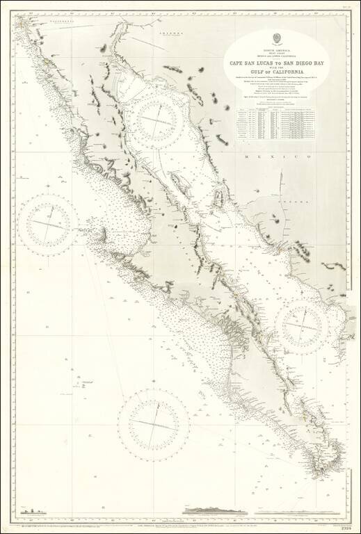
Large Sea Chart of Baja California and the Sea of Cortez / Gulf of California A fine example of the British Admiralty chart of Baja California and the Gulf of California, first engraved and published from London in 1879, and updated numerous times...
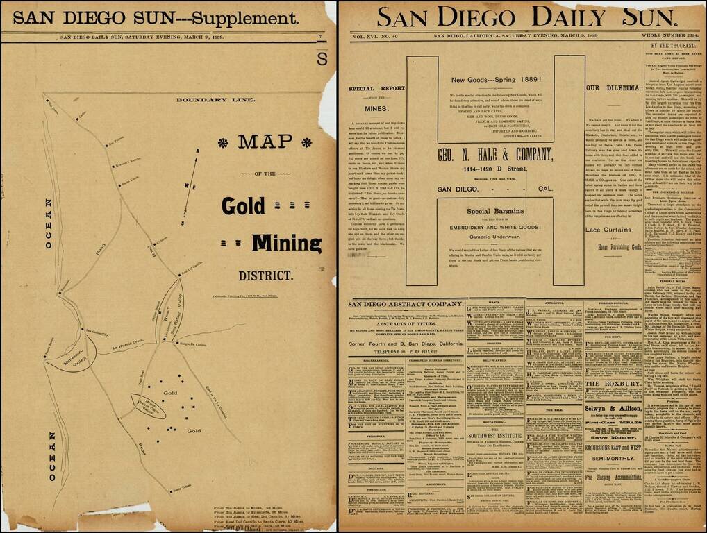
Rare map of the gold mining regions southeast of Ensenada near the Santa Clara Valley, published in the San Diego Sun in March 1889. The map shows the roads south from Tijuana to Ensenada and Santa Tomas, including the region identified as having Gold...