Map size in jpg-format: 81.4026MiB
Click to open in high resolution (open in new tab).

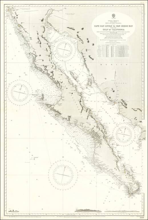
Large Sea Chart of Baja California and the Sea of Cortez / Gulf of California
A fine example of the British Admiralty chart of Baja California and the Gulf of California, first engraved and published from London in 1879, and updated numerous times thereafter. The map shows the Baja Peninsula and Gulf of California (Sea of Cortez) from San Diego, California to Cabo San Lucas, Mexico.
The chart contains detailed names of the numerous rivers, lights, capes, and bays surrounding the Baja Peninsula. This includes: Todos Santos Bay, Rosario Bay, Boca de Santo Domingo, Port San Bartolome, Cape San Lazaro, Santa Margarita Island, Lusitania Bank, Magdalena Bay, Pescadero Point, San Jose del Cabo Bay, Ceralbo Island, and San Jose Island. It also shows La Jolla, "Old San Diego," Mt. Soledad, Point Loma, as well as several Coastal Range peaks that have been renamed.
In addition, detailed navigational information is provided. The chart shows soundings to the edge of the nearshore shelf, major landmarks, as well as including three engravings at the bottom of the chart depicting Cabo San Lucas and Alijos Rocks. Details on wrecks, such as that of the Golden Gate, are provided. Some inland detail is provided, including railroads and mountains, but these are mostly provided for navigational purposes.
A fine example of this well-executed chart.
The British Admiralty has produced nautical charts since 1795 under the auspices of the United Kingdom Hydrographic Office (HO). Its main task was to provide the Royal Navy with navigational products and service, but since 1821 it has also sold charts to the public.
In 1795, King George III appointed Alexander Dalrymple, a pedantic geographer, to consolidate, catalogue, and improve the Royal Navy’s charts. He produced the first chart as the Hydrographer to the Admiralty in 1802. Dalrymple, known for his sticky personality, served until his death in 1808, when he was succeeded by Captain Thomas Hurd. The HO has been run by naval officers ever since.
Hurd professionalized the office and increased its efficiency. He was succeeded by the Arctic explorer Captain William Parry in 1823. By 1825, the HO was offering over seven hundred charts and views for sale. Under Parry, the HO also began to participate in exploratory expeditions. The first was a joint French-Spanish-British trip to the South Atlantic, a voyage organized in part by the Royal Society of London.
In 1829, Rear-Admiral Sir Francis Beaufort was appointed Hydrographer Royal. Under his management, the HO introduced the wind force scale named for him, as well as began issuing official tide tables (1833). It was under Beaufort that HMS Beagle completed several surveying missions, including its most famous voyage commanded by Captain FitzRoy with Charles Darwin onboard. When Beaufort retired in 1855, the HO had nearly two thousand charts in its catalog.
Later in the nineteenth century, the HO supported the Challenger expedition, which is credited with helping to found the discipline of oceanography. The HO participated in the International Meridian Conference which decided on the Greenwich Meridian as the Prime Meridian. Regulation and standardization of oceanic and navigational measures continued into the twentieth century, with the HO participating at the first International Hydrographic Organization meeting in 1921.
During World War II, the HO chart making facility moved to Taunton, the first purpose-built building it ever inhabited. In 1953, the first purpose-built survey ship went to sea, the HMS Vidal. Today, there is an entire class of survey vessels that make up the Royal Navy’s Hydrographic Squadron. The HO began to computerize their charts in the late 1960s and early 1970s. In 1968, the compilation staff also came to Taunton, and the HO continues to work from there today.
If you are a student, write to us in telegram: @antiquemaps and indicate what material you need and for what work you need a map in high detail. We are ready to provide material on special terms. For students only!