
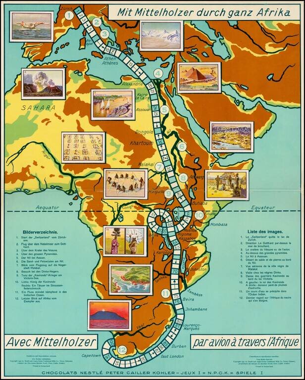
Rare commemorative game board map of Africa for a promotional game published for the Nestle Company, for tracking the trip of Walter Mittelholzer across Africa. Walter Mittelholzer (1894 - 1937) was a Swiss aviation pioneer. He was active as a pilot,...

Whimsical map depicting the route of the USS Independence, from Norfolk to the Arabian Sea. On November 19, 1980, the USS Independence deployed to the Indian Ocean along with the Harry E. Yarnell (CG-17) and was on watch along with the Ranger on...
![[Facsimile - 15th Century Portolan Sea Chart] Portolan des Iehuda ben Zara](/map/small/64285.jpg)
Impressive modern facsimile of the Iehuda Ben Zara portolan of the Mediterranean from 1497. The beautiful chart extends from the British Isles in the northwest to the Red Sea in the southeast and depicts all of the Mediterranean with the exception of...
![[Arabian Peninsula, Red Sea, Nile River and Gulf of Aden] L'Afrique . . . 1740](/map/small/59382.jpg)
Title cartouche section of the Le Rouge wall map of Africa, published in Paris in 1740. The map includes a decorative cartouche showing Europeans trading gold and slaves with local African leaders.
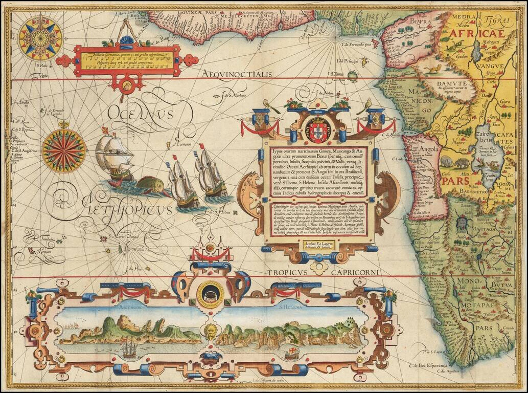
Fine Sixteenth-Century Decorative Map of South and West Africa from Linschoten's Influential Itinerario Striking map of South Africa, West Africa and contiguous parts of the Atlantic. This is one of the most richly ornamented maps of the era,...
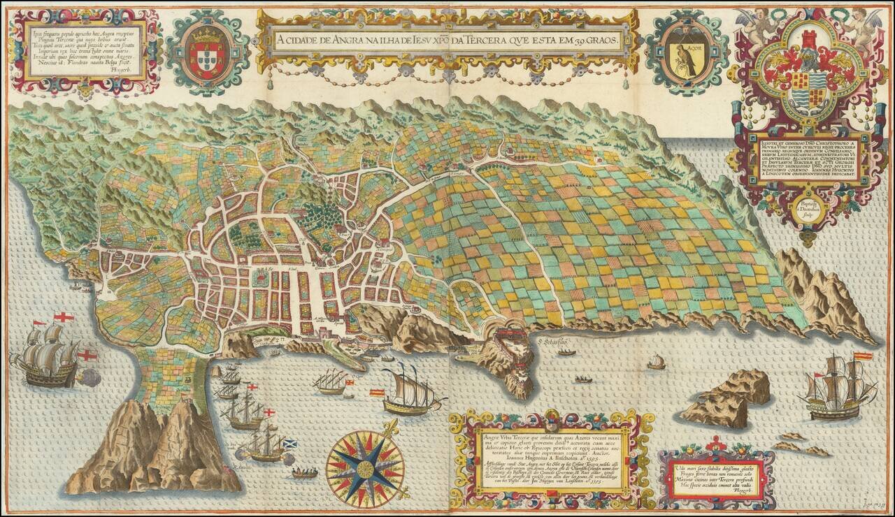
Spectacular birds-eye view of the island of Terceira and the town of Angra. Engraved by Baptista van Deutecum in Amsterdam, for LInschoten's Itinerario. Linschoten's view of Terceira in the Azores is one of the most decorative and recognizable...
![[Ascension Island] The True Description of the Island of Ascention lyeing under 8 degrees on ye South syde of ye Equinoctiall lyne.](/map/small/69468.jpg)
Antique engraved view of the Island of Ascension (St. Helena), which appeared in the rare English edition of Linschoten's Itinerario, Iohn Huighen van Linschoten. His discours of voyages . . . , published in London in 1598, and engraved by Englishman...

Rare sea chart of the Canary Islands, from Blaeu's Sea Atlas. Blaeu' Zeespiegel was one of the most important Rutters or Sea-Atlases of its time. Willem Janszoon Blaeu published two great pilot guides: the first ( Het Licht der Zee-vaert) was...
Fine example of Robert Dudley's chart of the coast of southern Africa, the earliest obtainable sea chart of the general region. The map covers the area south of the entrance to the Congo River, around the Cape of Good Hope, to Isle Monfin (Mafia...
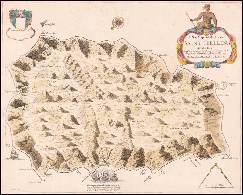
An English Rarity Rare separately published map of the Island of St. Helena, published by John Seller in London. This is the first map of St. Helena to be published in English and initially appeared in Seller's Atlas Maritimus . . . in 1675. The...
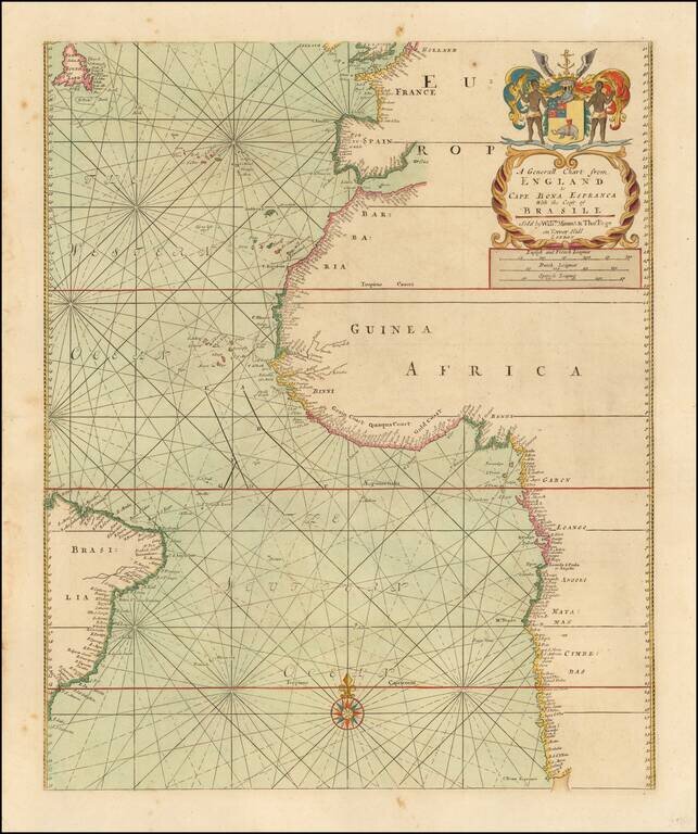
Fine sea chart of the Southern Atlantic Ocean, first published in London by John Thornton. The general map from Thornton's English Pilot The Third Book, concentrating on oriental navigation, showing the first half of the route to the Far East. The...

Fine Example of a Norie Blueback Chart of the Atlantic and Indian Oceans Impressive, rare example of a blueback chart of the southern Atlantic and Indian Oceans, showing the major shipping routes around the Cape of Good Hope. The chart, twice...
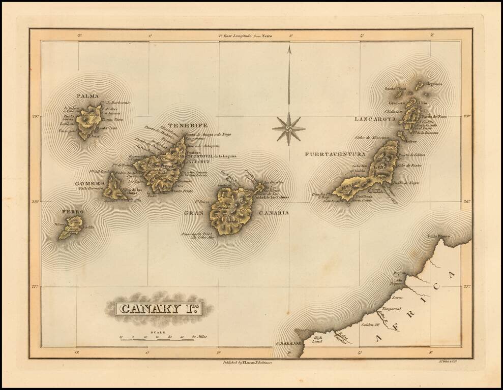
Scarce map of the Canary Islands by Fielding Lucas Jr., which appeared in his General Atlas, as well as his A New General Atlas of the West India Islands. Lucas's map is one of the first detailed commercial maps of the Canary Island published in...
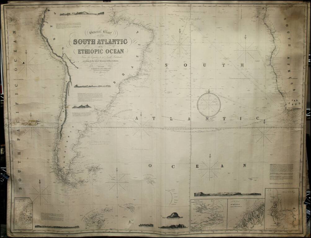
Fine working sea chart of the South Atlantic, showing the parts of South America and Africa in the Southern Hemisphere. Includes insets of the Falklands, Table Bay and St. Helena, along with several profile views.
![[Rare English Edition!] Delineatio Orarum Maritimarum, Terrae vulgo Indigetatae Terra do Natal, item Sofalae, Mozambicae, & Melindae . . . / The description or Caerd of the Coastes of the Countreys following called ~ Terra do Natal, all the Coast of S](/map/small/69464.jpg)
Rare English Edition -- Stunning Map of Eastern Africa Striking example of the rare English Edition of Linschoten's map of Eastern Africa, which appeared in the rare English edition of Linschoten's Itinerario, Iohn Huighen van Linschoten. His discours...
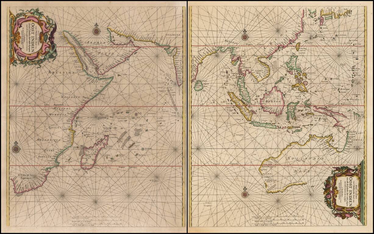
Rare Sea Chart of Australia, Southeast Asia, and the Indian Ocean from the Dutch Golden Age of Cartography Early pair of sea charts of the Indian Ocean and contiguous regions. Australia is remarkably delineated for this early date and reflects recent...