Sebastian Münster (1488-1552) was a cosmographer and professor of Hebrew who taught at Tübingen, Heidelberg, and Basel. He settled in the latter in 1529 and died there, of plague, in 1552. Münster made himself the center of a large network of scholars from whom he obtained geographic descriptions, maps, and directions.
As a young man, Münster joined the Franciscan order, in which he became a priest. He then studied geography at Tübingen, graduating in 1518. He moved to Basel, where he published a Hebrew grammar, one of the first books in Hebrew published in Germany. In 1521 Münster moved again, to Heidelberg, where he continued to publish Hebrew texts and the first German-produced books in Aramaic. After converting to Protestantism in 1529, he took over the chair of Hebrew at Basel, where he published his main Hebrew work, a two-volume Old Testament with a Latin translation.
Münster published his first known map, a map of Germany, in 1525. Three years later, he released a treatise on sundials. In 1540, he published Geographia universalis vetus et nova, an updated edition of Ptolemy’s Geographia. In addition to the Ptolemaic maps, Münster added 21 modern maps. One of Münster’s innovations was to include one map for each continent, a concept that would influence Ortelius and other early atlas makers. The Geographia was reprinted in 1542, 1545, and 1552.
He is best known for his Cosmographia universalis, first published in 1544 and released in at least 35 editions by 1628. It was the first German-language description of the world and contained 471 woodcuts and 26 maps over six volumes. Many of the maps were taken from the Geographia and modified over time. The Cosmographia was widely used in the sixteenth and seventeenth centuries. The text, woodcuts, and maps all influenced geographical thought for generations.
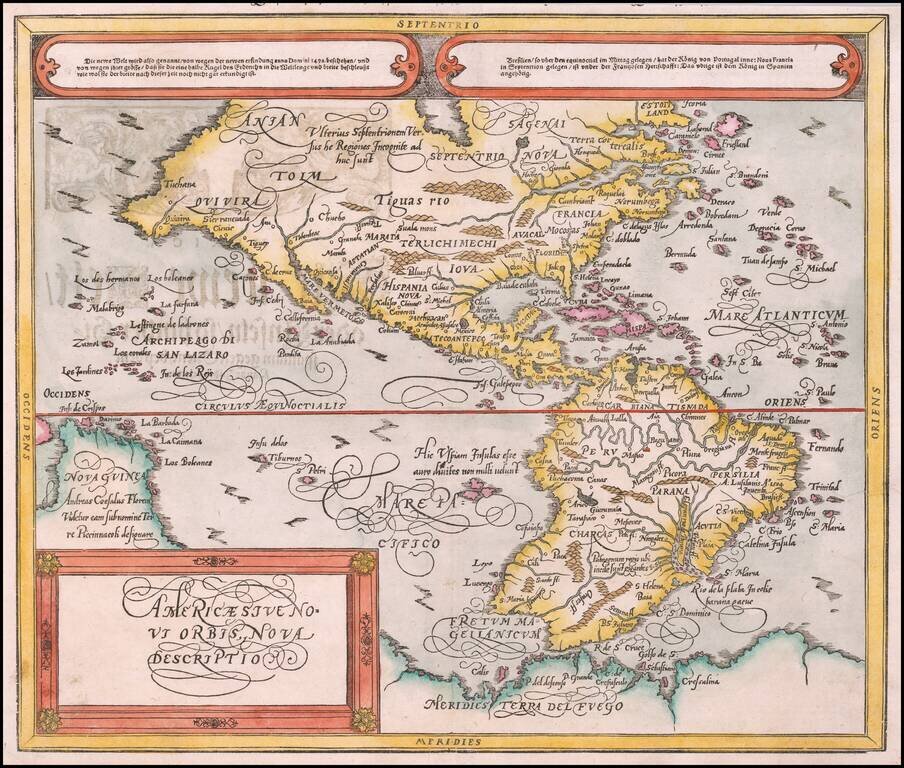
![[First Map of the American Continent] Tavola dell' isole nuove, le quali son nominate occidentali, & indiane per diversi rispetti.](/map/small/67312.jpg)
First Printed Map of the American Continent Early state of Sebastian Münster’s map of America, the earliest to show all of North and South America in a true continental form with a continuous coastline. It is also the first to use Mare Pacificum as...
Nicely colored example of Munster's second map of America. By 1588, Munster's first map of America (first issued in 1540) had become dated. It was decided to update the 1540 map of America with a a new map based upon the second edition of Ortelius'...
![Meerwunder und Seltzame Thier/Wie Die In Den Mitnacßtigen Landern Gefunden Werden [Munster's Famous Chart of Sea Monsters]](/map/small/70061.jpg)
Münster’s Monster Menagerie Fine example of Münster’s sought-after chart of terrestrial and sea monsters. The imagery is based in large part on Olaus Magnus' famed, and unobtainable, Carta Marina of 1539. The chart was published as part of...
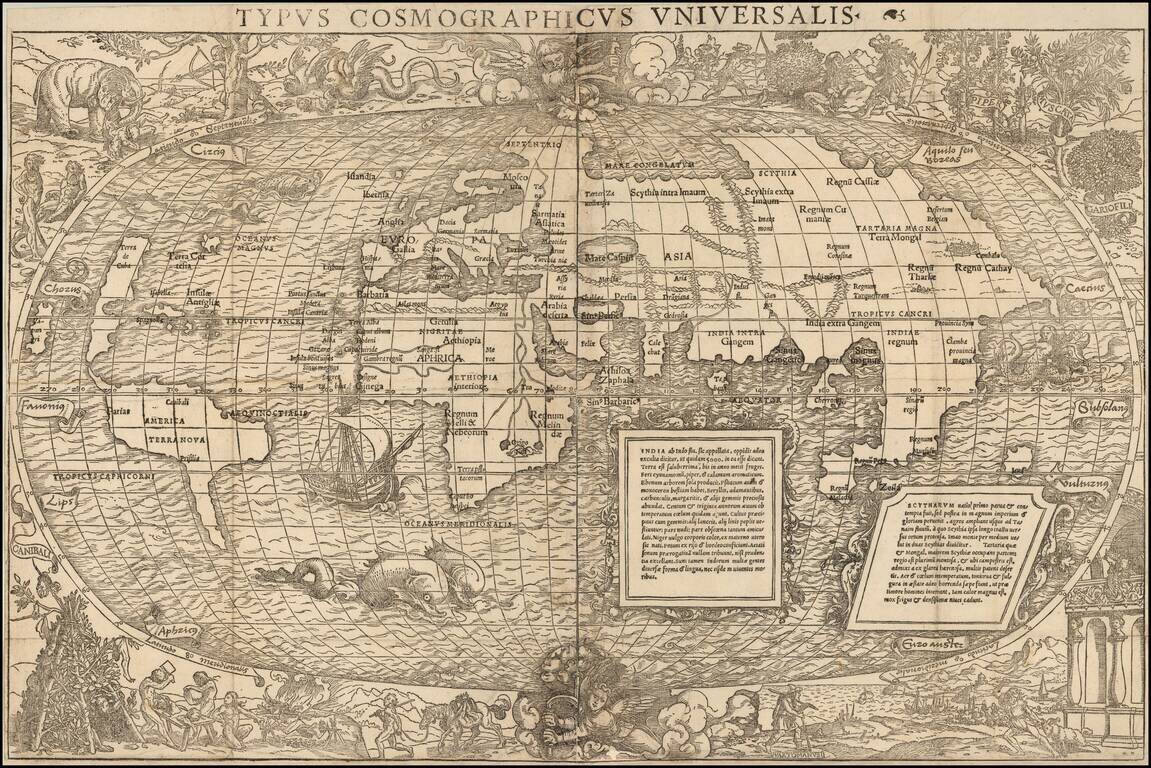
One of the Most Interesting Antique World Maps of the 16th Century A fine example of the Grynaeus / Munster map of the World, considered "from the artistic point of view one of the most interesting of the many world maps turned out in the sixteenth...
First edition of Munster's map of the World, one of the most recognized world maps of the 16th century. This example is from the first woodblock (1540-1545), which can be distinguished from the editions of 1550 and after, the later editions being...
![[Modern World] Das Erst General / inhaltend die beschreibung . . .](/map/small/70265.jpg)
Münster's 1548 Modern Map of the World, an Iconic Image of the Globe Fine example of the second edition of Münster's map of the world, one of the most recognized and influential world maps of the sixteenth century. Munster's map is considered one...

Nice full color example of Munster's first ancient map of the World, based upon the writings of Ptolemy. At the advent of printing in the 15th Century, the geographical works of Ptolemy were at their highpoint. Virtually all of the printed maps in the...

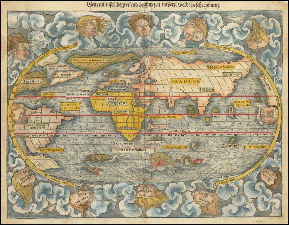
Updated Map of the World From Munster's Cosmographia. Decorative example of this revised and updated map of the World, based upon Abraham Ortelius' world map, which appeared in Munster's Cosmographia after 1588. This map first appeared in the...
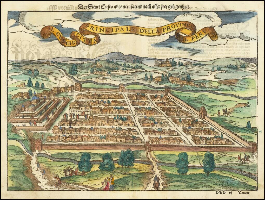
Early decorative birdseye view of Cusco, from a German edition of Munster's Cosmographia, one of the most influential geographical works of the 16th Century. One of the earliest obtainable views of the New World. Munster's Geographia was a...
![[Europe as a Queen | Europa regina]](/map/small/68327.jpg)
This is a nice full-color example of Munster's map of Europe in the shape of a queen. The regent's head and crown constitute the Iberian Peninsula, her arms Italy and Denmark, and her dress the countries from France to Bulgaria. In what might be...
![Tabula Europae I [British Isles]](/map/small/62810.jpg)
First edition, second state of Munster's map of the British Isles. Includes a large ship in the Northern Sea and an interesting projection of the Albion and Hibernia. The map is unchanged from the 1540 edition. Munster's Geographia was a cartographic...
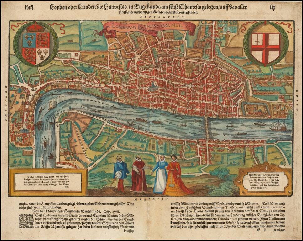
Nice full color example of Munster's map of London, which appeared only in the later editions of Munster's Cosmography. Striking double page city view of the city of London showing the area between Clerkenwell, Wapping, Southwark and Westminster...
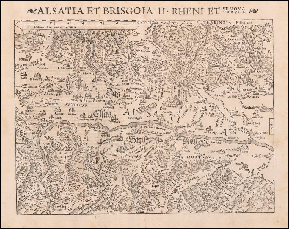
One of the earliest Modern Maps of the Rhine River Valley Detailed map of the Rhine River Valley, from Strasbourg and Argentina to Basel and Laufenberg, centered on Brisach and Kappel and showing Colmar. West is at the top of the map. The map is...
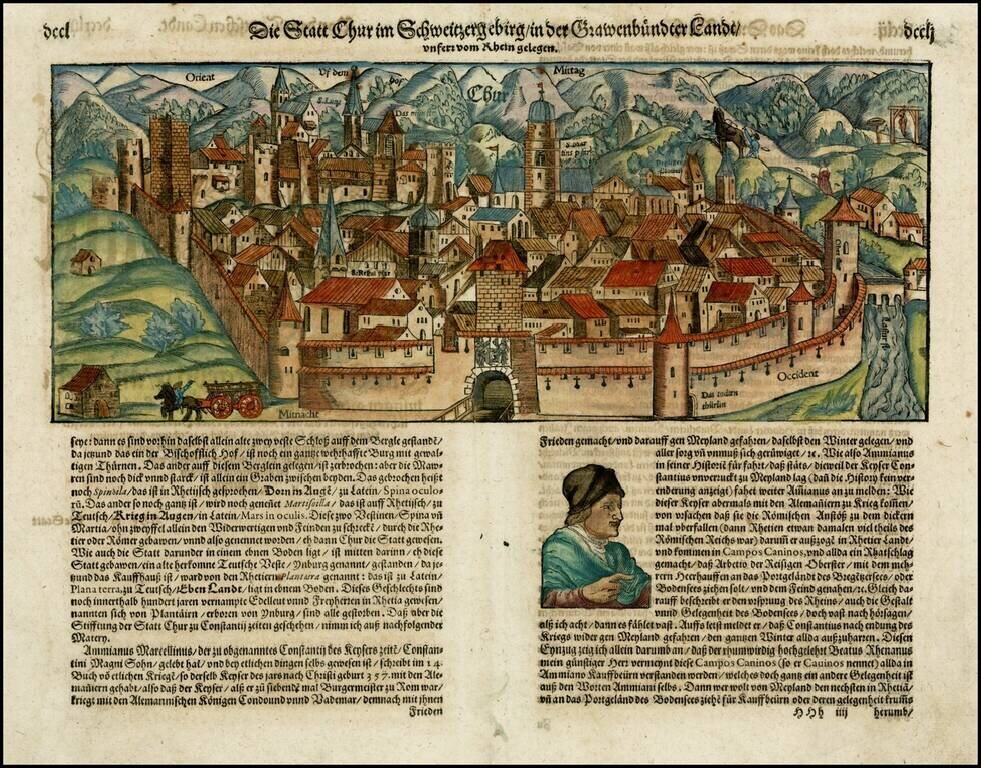
Early decorative birdseye view of Chur from an early German edition of Munster's Cosmography, one of the most influential georgaphical works of the 16th Century.
Fine early view of Chur, from and early edition of Munster's Cosmographia. Woodcut view of the walled city of Chur, in the Swiss canton of Grabünden. The area, settled over five thousand years ago, lays claim to being the oldest city in Switzerland....
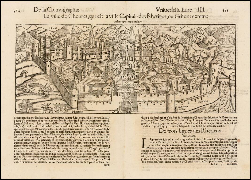
Early decorative birdseye view of Chur from a French edition of Munster's Cosmography, one of the most influential georgaphical works of the 16th Century.