Sebastian Münster (1488-1552) was a cosmographer and professor of Hebrew who taught at Tübingen, Heidelberg, and Basel. He settled in the latter in 1529 and died there, of plague, in 1552. Münster made himself the center of a large network of scholars from whom he obtained geographic descriptions, maps, and directions.
As a young man, Münster joined the Franciscan order, in which he became a priest. He then studied geography at Tübingen, graduating in 1518. He moved to Basel, where he published a Hebrew grammar, one of the first books in Hebrew published in Germany. In 1521 Münster moved again, to Heidelberg, where he continued to publish Hebrew texts and the first German-produced books in Aramaic. After converting to Protestantism in 1529, he took over the chair of Hebrew at Basel, where he published his main Hebrew work, a two-volume Old Testament with a Latin translation.
Münster published his first known map, a map of Germany, in 1525. Three years later, he released a treatise on sundials. In 1540, he published Geographia universalis vetus et nova, an updated edition of Ptolemy’s Geographia. In addition to the Ptolemaic maps, Münster added 21 modern maps. One of Münster’s innovations was to include one map for each continent, a concept that would influence Ortelius and other early atlas makers. The Geographia was reprinted in 1542, 1545, and 1552.
He is best known for his Cosmographia universalis, first published in 1544 and released in at least 35 editions by 1628. It was the first German-language description of the world and contained 471 woodcuts and 26 maps over six volumes. Many of the maps were taken from the Geographia and modified over time. The Cosmographia was widely used in the sixteenth and seventeenth centuries. The text, woodcuts, and maps all influenced geographical thought for generations.
![[Rome] Die Statt Rom . . .](/map/small/62058.jpg)
Striking view of Rome from Munster's Cosmographia. Munster's view captures a fine sense of the fortified walls and Seven Hills of the Eternal City, with significant activity along the Tiber River. Many of Rome's great landmarks are clearly...
![[Rome] Die Statt Rom in aller Welt](/map/small/68874.jpg)
Striking view of Rome from Munster's Cosmographia. Munster's view captures a fine sense of the fortified walls and Seven Hills of the Eternal City, with significant activity along the Tiber River. Many of Rome's great landmarks are clearly...
![[Ancient Rome] La figure de la place ou fut iadiz la cite de Rome avec ses portes, quand elle estoit en la grand fleur](/map/small/64173.jpg)
Detetailed regional map of ancient Rome, from Munster's Cosmographia, one of the most influential books of the 16th Century.
![[Florence] Florentz](/map/small/62199.jpg)
Detailed view of the City of Florence, set with a decorative engraved title frame. Large coat of arms, held aloft by two angels, with two additional cherubs in the upper left and right corner. Major landmarks (Duomo, Ponte Vecchio, etc.) are plainly...
![Hispanicae Regionis Nova Descriptio [Spain & Portugal]](/map/small/58846.jpg)
The first state of Munster's map of the Iberian Peninsula, one of the earliest obtainable maps of Spain and Portugal. The map shows cities, rivers, mountain ranges, the Balleric Islands and other details. The map is unchanged from the 1540 edition....
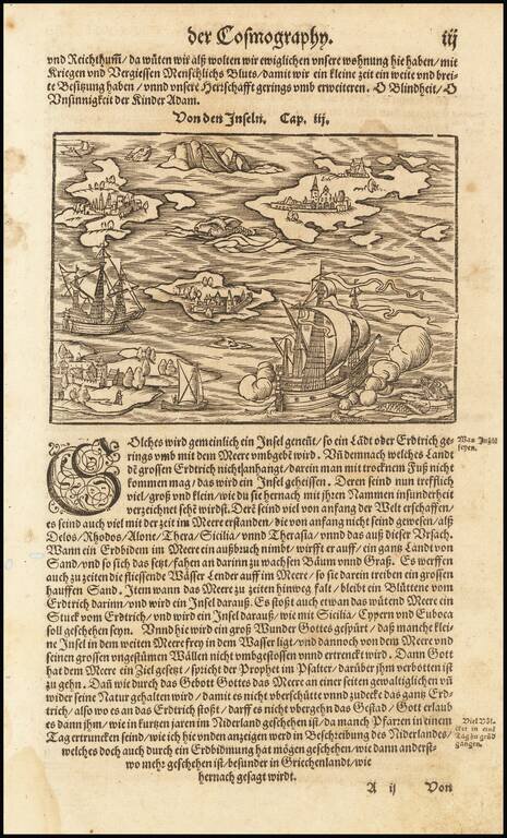
Fascinating map of a ship in the Mediterranean. Islansd mentioned in the text include Sicily, Rhodes, Delos, Alone, and Thera.
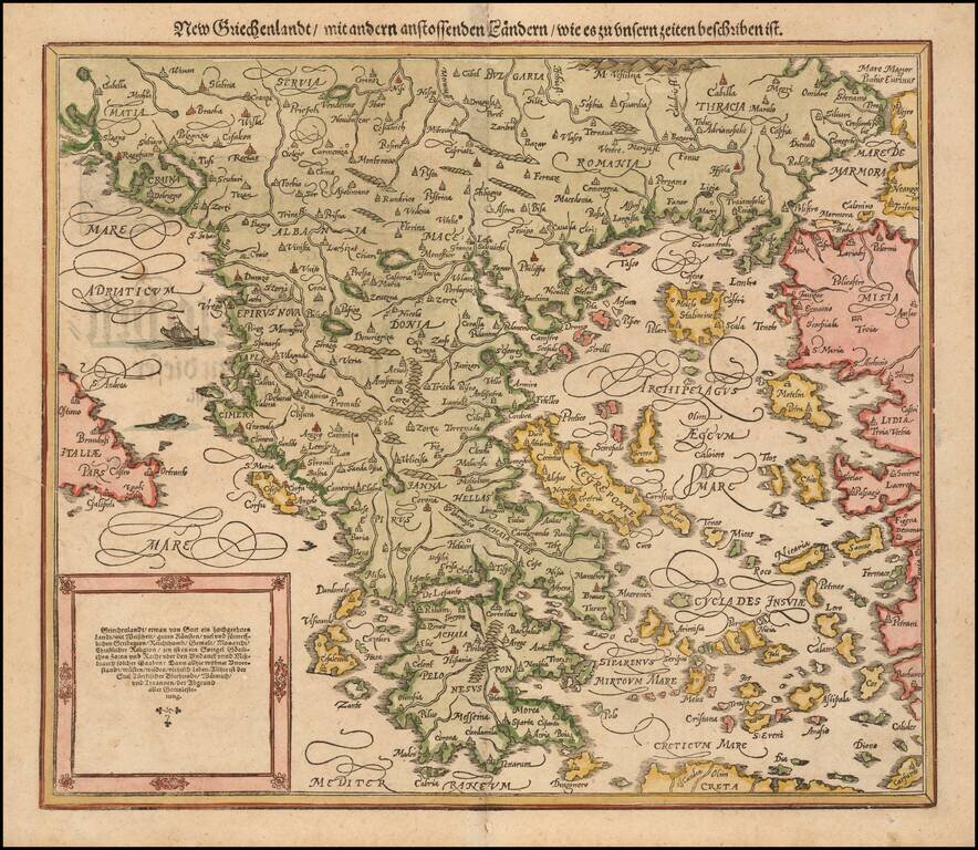
Nice full color example of Munster's second map of modern Greece, from Munster's Cosmographia, one of the most influential georgaphical works of the 16th Century. Munster's Geographia (first published in 1540), and his later Cosmographia, were...
![[Asia Minor] Tabula Asiae I](/map/small/70464.jpg)
Nice example of Munster's Ptolemaic map of Asia Minor and parts of the Black Sea and Cyprus. From an early edition of Munster's Geographia, one of the most important works of the 16th Century. Sebastien Munster is generally regarded as one of the...

Finely colored early view of Constantinople (Istanbul), one of the earliest widely distributed views of the City from the 16th Century. Munster's Geographia (first published in 1540), and his later Cosmographia, were cartographic landmarks. The...
![Elba [and] Sicilia](/map/small/65810.jpg)
Fine example of Munster's map of the Island of Sicily (with Elba on the verso, from and early edition of Munster's Cosmographia. Munster's Cosmographia was one of the most influential works of the 16th Century. The work was first issued in 1545 and...
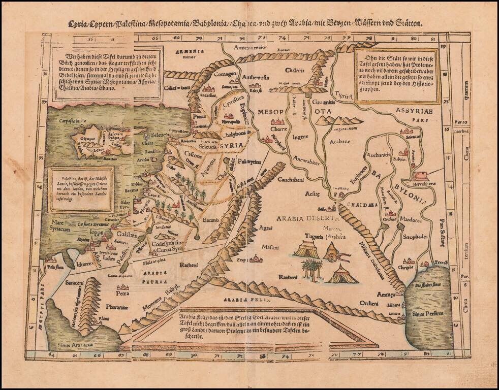
Colored example of Munster's map of Cyprus, Syria, the Holy Land and contiguous regions, from an early edition of Munster's Cosmographia. Munster's Cosmographia was one of the most influential geographical works of the 16th Century and had a profound...
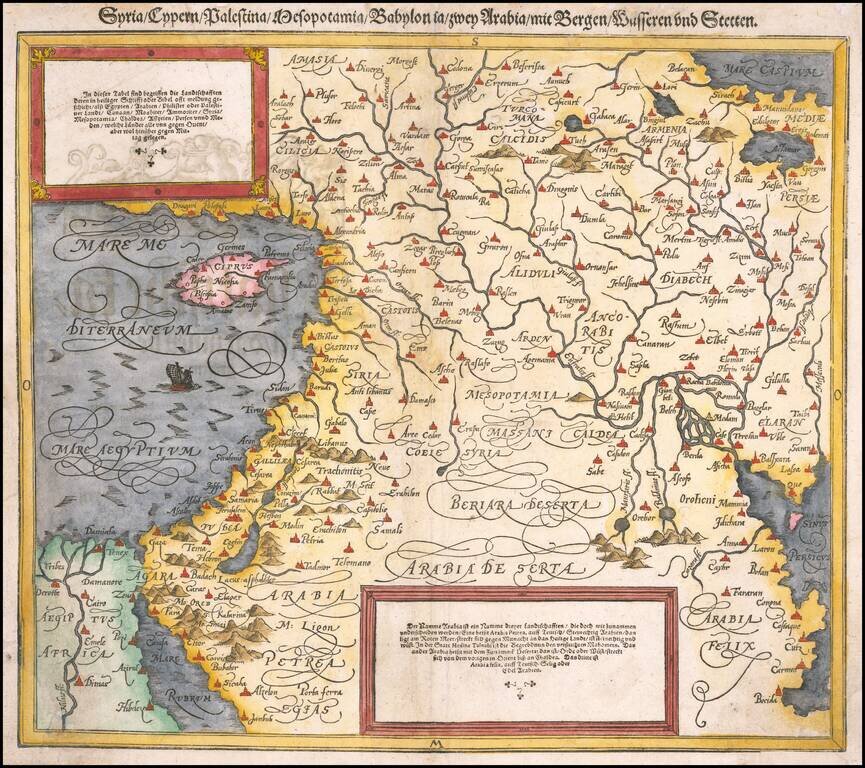
Finely colored map of Cyprus, Syria, the Holy Land and contiguous regions, from an early edition of Munster's Cosmographia. Munster's Cosmographia was one of the most influential geographical works of the 16th Century and had a profound impact on the...
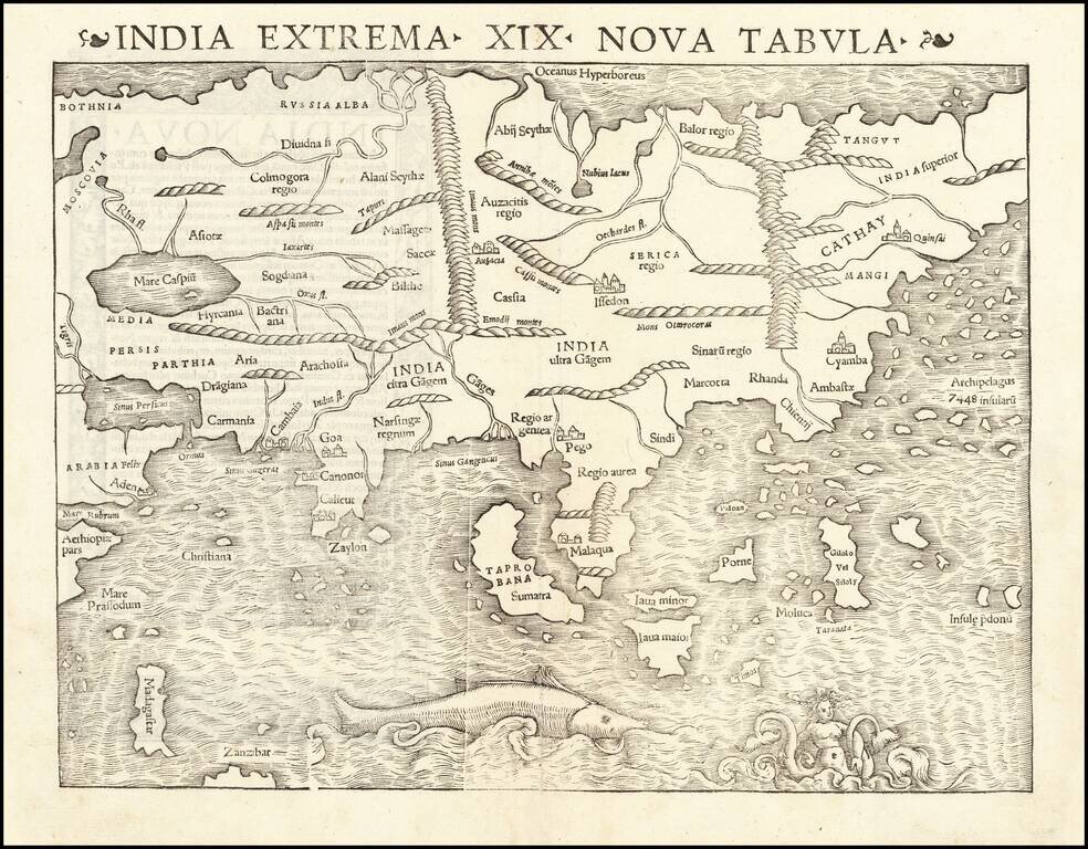
Rare Early State of the First Modern Map of the Asian Continent. Nice example of the first printed map of Asia, published by Sebastian Munster, from the 1542 edition of Munster's Geographia. The map shows Asia from the Caspian Sea and Persian Gulf...
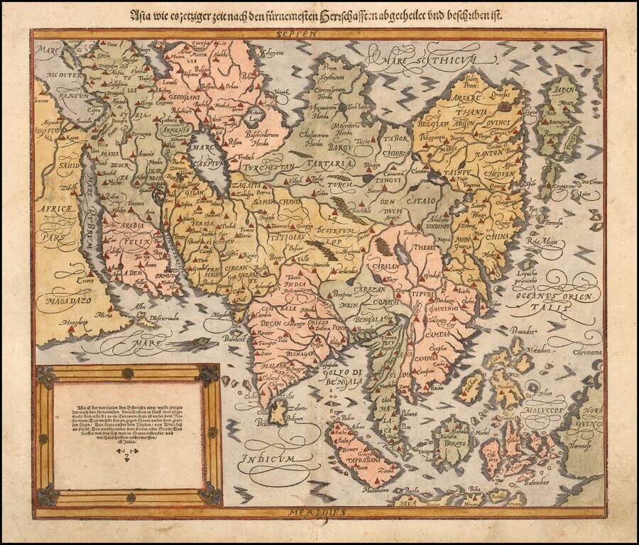
Decorative example of Sebastian Munster's second map of Asia, first published in 1588. The map is significantly updated from Munster's first map of Asia, which was published in 1540 and, when issued, was the first printed map of the Asian Continent....
![Tabula Asiae VII [Iran, Afghanistan, Turkmenistan, Uzbekistan, Kazakhastan, Pakistan, India]](/map/small/60604.jpg)
Nice example of Munster's Ptolemaic map of the region north and east of the Black Sea and the Persian Gulf, extending to the Imaus Mountains. The map is unchanged from the 1540 first edition of this landmark work. Munster's Geographia was a...
![[Black & Caspian Sea Region] Tabula Asiae III](/map/small/71170.jpg)
Nice example of Munster's Ptolemaic map of the region between the Black Sea and Caspian Sea extending south to include all of Armenia Maior and part of Armenia Minoris. The map is centered on the modern countries of Armenia, Georgia and Azerbaijan....