Map size in jpg-format: 27.0212MiB
Click to open in high resolution (open in new tab).
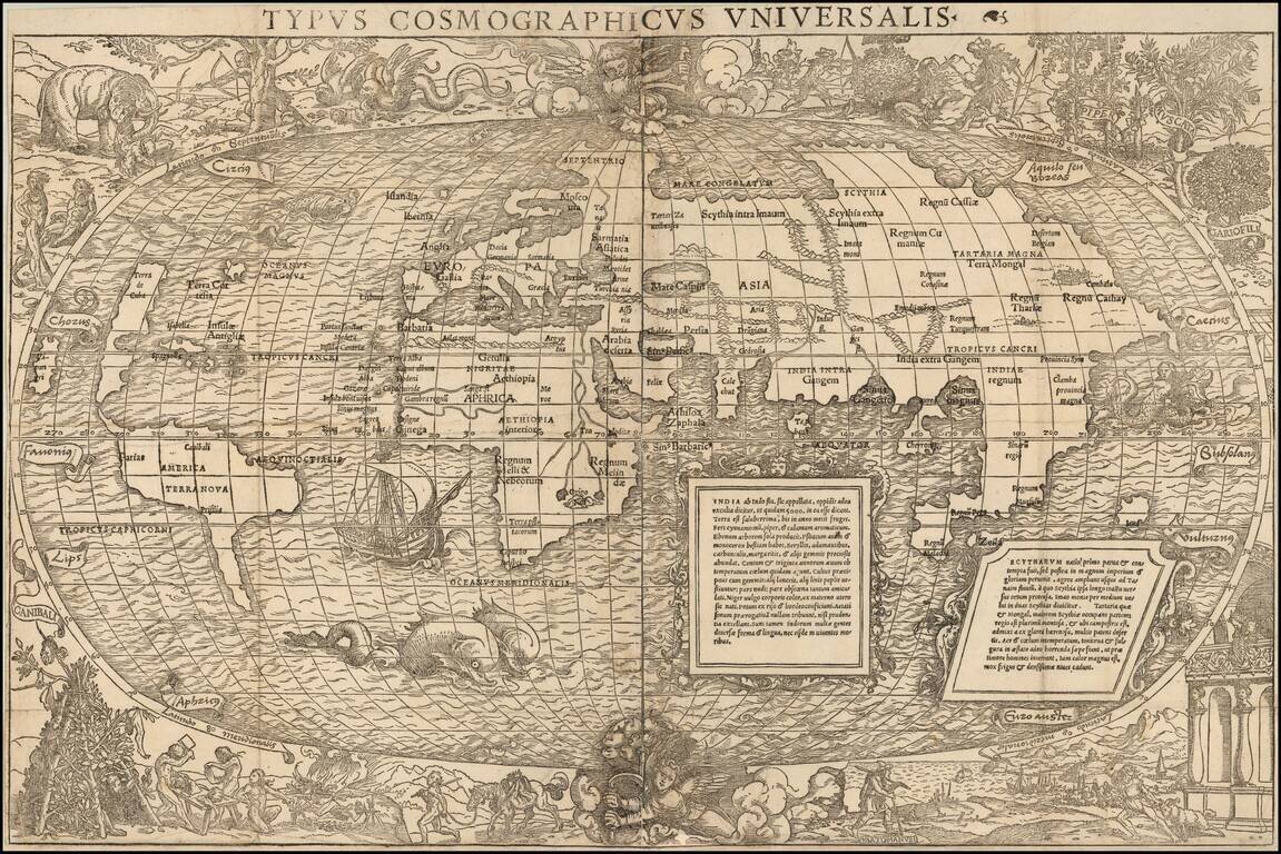
One of the Most Interesting Antique World Maps of the 16th Century
A fine example of the Grynaeus / Munster map of the World, considered "from the artistic point of view one of the most interesting of the many world maps turned out in the sixteenth century".
Of the map, Rodney Shirley notes:
No imprint appears on this large and decorative map . . which was first printed in the 1532 edition of the Novus Orbis Regionum by Johann Huttich and Simon Grynaeus. Sebastian Munster contributed a long introduction Typi Cosmographici et Declarato et usus to their collection of voyages, and there have been arguments for and against his authorship of the accompanying map. It seems more probable that the map itself is Munster's whereas the decor is more frequently attributed to Hans Holbein the Younger . . . Geographically the map . . . was probably prepared prior to 1532 based partly upon . . . the Schoner Globes, or on Apian's map of 1520. . . The projection follows the oval one of Bordone, with two cherubs energetically turning crank handles at the north and south poles.The map itself is by Sebastian Munster (1488-1552), the era's most prolific mapmaker, famous for his great geographical work, Cosmographia (Basle, 1540).
The map's exquisite border decorations as attributed to Hans Holbein the Younger (1497-1543), one of the greatest artists of the Northern Renaissance. Holbein, originally from Augsburg was working in Basle at the time, before moving to London to become the official court painter to Henry VIII.
Holbein's conception depicts World being turned on its axis by cranks wielded by a pair of angels. Some have theorized that this represents the first published depiction of the Copernican conception of the Earth pinned on its axis as it orbits the Sun (predating the publication of Copernicus' work in 1543). In reality, this was probably only an artistic conceit, albeit an intriguing one.
Beyond that, the elaborate borders are enhanced with imaginary scenes of cannibals, winged serpents, elephants, and monsters, all derived from popular, but largely fictitious travel accounts of the era, notably Amerigo Vespucci's Mundus Novus (1503).
The vignette labeled 'Vartomanusi' in the lower right corner, refers to the explorations of Southeast Asia conducted by the Bolognese adventurer Ludovico di Varthema (1470-1517). Varthema was famously the first Christian known to have visited Mecca, and from 1502 to 1507, he extensively explored India, Indochina and Indonesian Archipelago. His account of his travels, Itinerario de Ludouico de Varthema Bolognese (Rome, 1510), was one of the most captivating of the early period of global exploration. The vignette in the upper-right corner depicts the spices that were the focus of trade to the East Indies.
The map is one of the most decorative and sought after of all early world maps that are reasonably obtainable to most collectors, owing to the tremendous success of the Huttich-Grynaeus text.
If you are a student, write to us in telegram: @antiquemaps and indicate what material you need and for what work you need a map in high detail. We are ready to provide material on special terms. For students only!


