Jacques-Nicolas Bellin (1703-1772) was among the most important mapmakers of the eighteenth century. In 1721, at age 18, he was appointed hydrographer (chief cartographer) to the French Navy. In August 1741, he became the first Ingénieur de la Marine of the Depot des cartes et plans de la Marine (the French Hydrographic Office) and was named Official Hydrographer of the French King.
During his term as Official Hydrographer, the Depot was the single most active center for the production of sea charts and maps, including a large folio format sea-chart of France, the Neptune Francois. He also produced a number of sea-atlases of the world, e.g., the Atlas Maritime and the Hydrographie Francaise. These gained fame, distinction, and respect all over Europe and were republished throughout the 18th and even in the succeeding century.
Bellin also came out with smaller format maps such as the 1764 Petit Atlas Maritime, containing 580 finely detailed charts. He also contributed many of the maps for Bellin and contributed a number of maps to the 15-volume Histoire Generale des Voyages of Antoine François Prévost or simply known l'Abbe Prevost.
Bellin set a very high standard of workmanship and accuracy, thus gaining for France a leading role in European cartography and geography. Many of his maps were copied by other mapmakers of Europe.
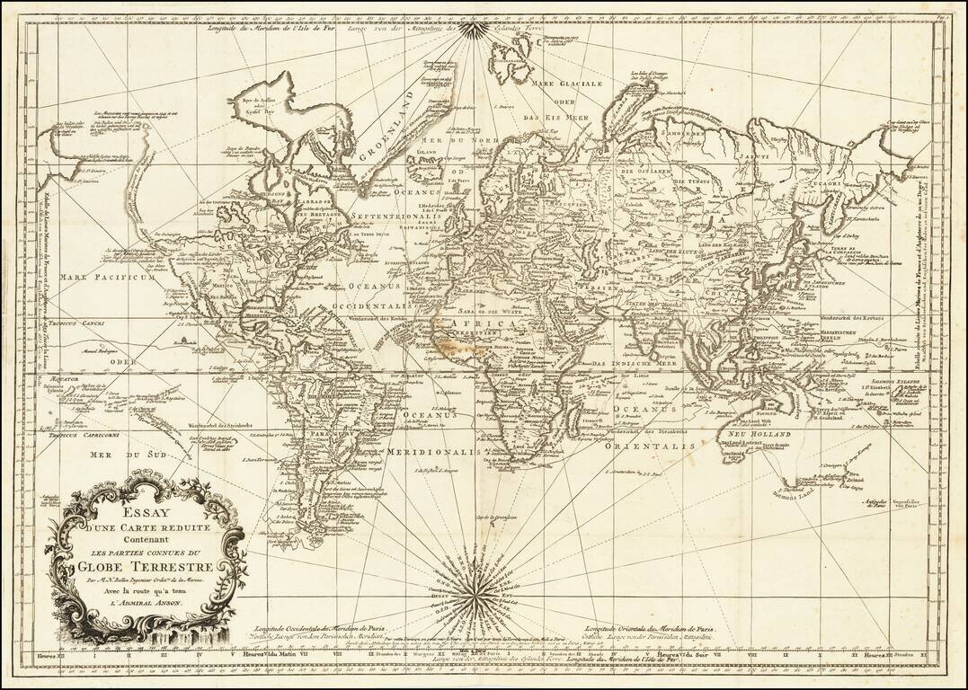
Rare Leipzig Bellin’s World Map Showing Both the Latest Discoveries and Lingering Geographic Questions Rare Leipzig edition of J.N. Bellin's influential mid-eighteenth-century map of the world, first published in Paris in 1748. The map shows...
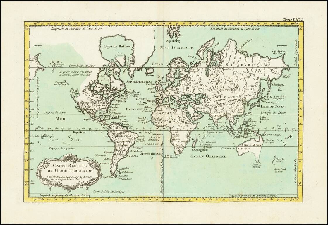
Finely engraved map of the World, from Jacques Nicolas Bellin's Le Petit Atlas Maritime Recueti de Cartes et Plans des Quatre Parties du Monde en Cinq Volumes, first published in Paris in 1764. The map shows Australia and New Zealand on the eve of...
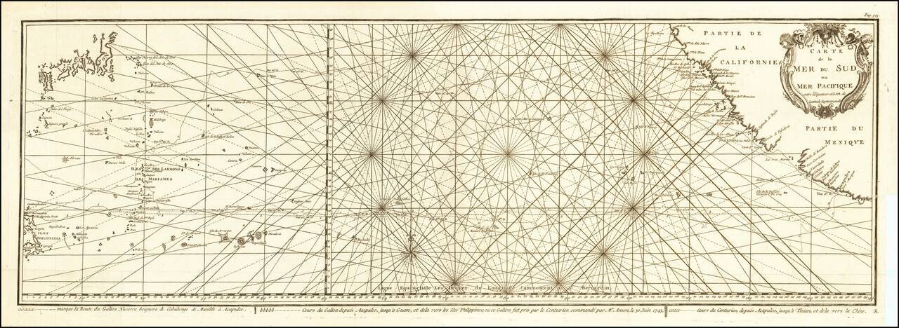
Impressive Chart of the Pacific Ocean Depicting a Thrilling Circumnavigation Dynamic chart of the mid-Pacific Ocean from the French-edition of Anson’s bestselling voyage account. It includes voyage tracks of Anson’s Centurion and the ship he...

Antique engraved map of the southern Atlantic Ocean, by Jacques Nicolas Bellin, the foremost French chartmaker of the 18th century. The map covers all of the eastern South American coast from Cape Horn to the mouth of the Amazon. In Africa, the map...
![Representation du Cours ordinaire des Vents de Traverse qui regnent les Cotes dans la grande Mer Du Sud [California as an Island]](/map/small/54744.jpg)
Interesting map charging the course of the trade winds in the Pacific Ocean, published by Bellin in the Histoire Generale de Voyages, based upon the obseravations of Dampier. California is shown as an island. An odd piece of the southern hemisphere...

Fine example of Bellin's map of New England and the Northeast Region. An excellent early map of the region bounded by New England, Lake Ontario and the northern Chesapeake River, centered on New York and Connecticut from Bellin's Histoire Generale des...
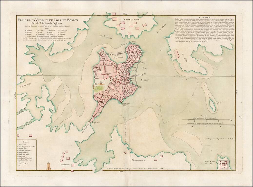
"This is the earliest detailed plan of the city of Boston published in France." (BPL) Featured on the Cover of Krieger and Cobb's Mapping Boston. Rare French plan of Boston, showing Charlestown to the north, and Dorchester and Roxbury to the south....
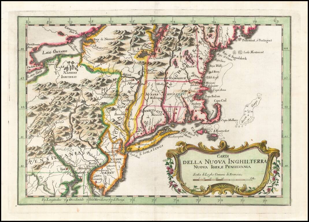
Rare Italian edition of Bellin's map of the Northeast and New England region, from his Teatro Della Guerre Marittima, published in Venice. The map covers the region from the Delaware River and New Jersey in the south to Maine and west to the...
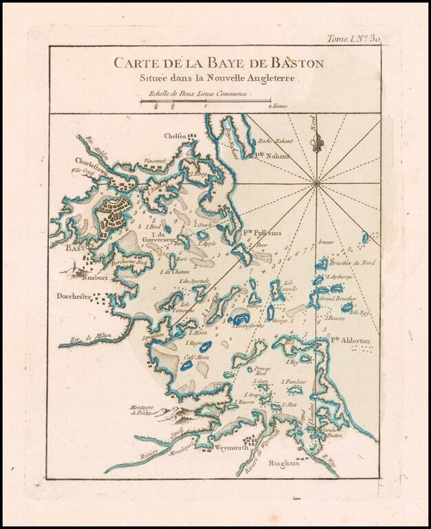
Boston Harbor at the end of the French & Indian War An excellent map of the Harbor of Boston, from Bellin's Le Petit Atlas Maritime.

The Earliest Obtainable Plan of New York. This map of the Fortress of New York was prepared by Bellin based upon an inset on Jean Baptiste-Louis Franquelin's map of 1693, which was originally prepared when France and England were at war and New...
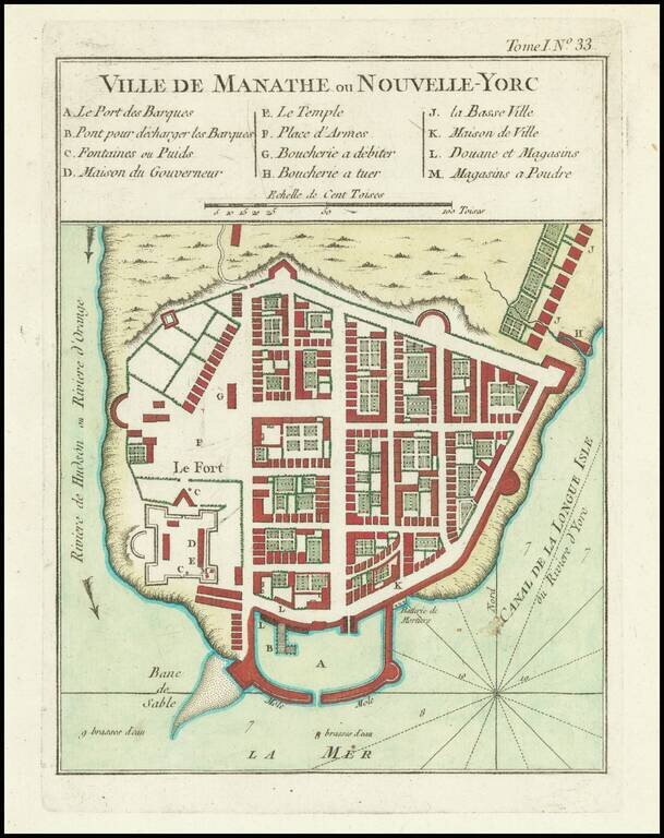
The Earliest Obtainable Plan of New York. This map of the Fortress of New York was prepared by Bellin based upon an inset on Jean Baptiste-Louis Franquelin's map of 1693, which was originally prepared when France and England were at war and New...
![[Niagara Falls] Wasserfall von Niagra](/map/small/69038.jpg)
Fine small image of Niagara Falls. The image is a close derivative of the first image of Niagara Falls by Louis Hennepin, which originally appeared in 1697. The main difference is that the image has been reversed. Also, one of Hennepin's four...
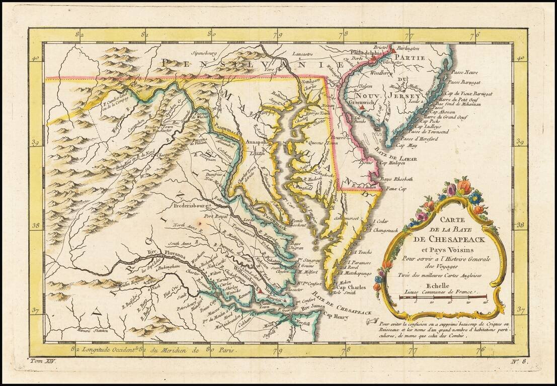
An excellent map of Virginia, Maryland, Delaware, and part of New Jersey. Extends west to the Applachians and shows towns, roads, mountains, rivers, islands, capes, ports and other nice details. A nice French & Indian War map of the Southern...
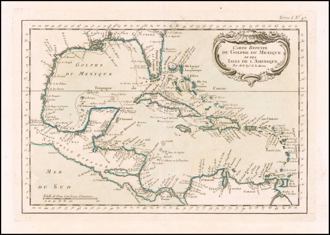
Detailed map of the Caribbean, published in Nicholas Bellin's Petit Atlas Maritime. The map covers The Gulf Coast, Florida, the Caribbean, Mexico, Yucatan and Central America.
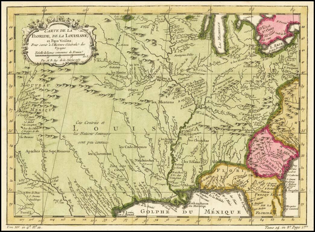
Rare Variant edition of Bellin's map of Mississippi River Valley and environs, with the name "Floride" in the title. The normal title for this map is Carte De La Louisiane et Pays Voisins. Fabulous map of most of the US, based upon De L'Isle's...
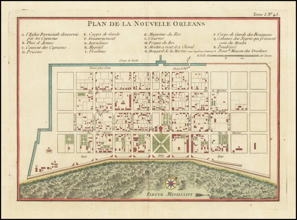
Bellin's important early map of New Orleans, first issued in Xavier Charlevoix's Histoire de la Nouvelle France. The present example is the second state of the map. The first state is distinguishable from subsequent states by the inclusion of the...