Jacques-Nicolas Bellin (1703-1772) was among the most important mapmakers of the eighteenth century. In 1721, at age 18, he was appointed hydrographer (chief cartographer) to the French Navy. In August 1741, he became the first Ingénieur de la Marine of the Depot des cartes et plans de la Marine (the French Hydrographic Office) and was named Official Hydrographer of the French King.
During his term as Official Hydrographer, the Depot was the single most active center for the production of sea charts and maps, including a large folio format sea-chart of France, the Neptune Francois. He also produced a number of sea-atlases of the world, e.g., the Atlas Maritime and the Hydrographie Francaise. These gained fame, distinction, and respect all over Europe and were republished throughout the 18th and even in the succeeding century.
Bellin also came out with smaller format maps such as the 1764 Petit Atlas Maritime, containing 580 finely detailed charts. He also contributed many of the maps for Bellin and contributed a number of maps to the 15-volume Histoire Generale des Voyages of Antoine François Prévost or simply known l'Abbe Prevost.
Bellin set a very high standard of workmanship and accuracy, thus gaining for France a leading role in European cartography and geography. Many of his maps were copied by other mapmakers of Europe.
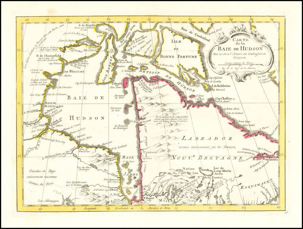
An excellent map of Hudson's Bay, Labrador, Hudson's Straits and neighboring regions from Bellin's Histoire General des Voyages. Includes numerous bays, islands, rivers, mountains and notes regarding explorations.
![Carte Reduite des Isles Antilles Dressee au Depost des Cartes et Plans de la Marine… [Large Inset of Virgin Islands]](/map/small/68206.jpg)
Large engraved sea chart of the Lesser Antilles, with a detailed inset of the Virgin Islands, published by Jacques Nicolas Bellin in 1758. The Virgin Islands inset at the left is titled "Carte Particuliere des Isles des Vierges". Bellin credits the...
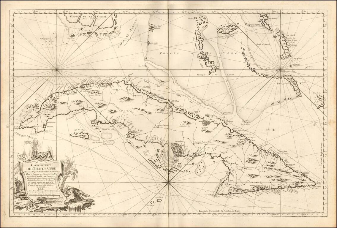
Fine Large Format Chart of Cuba By France's Royal Hydrographer Superb, large sea chart covering all of Cuba with the Florida Keys and the southern Bahamas from Bimini eastward, published in Paris for the Depot de la Marine, by Jacques Nicolas...
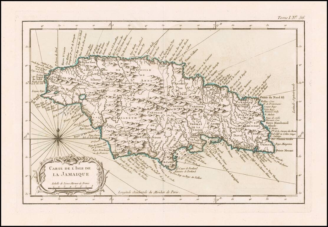
Detailed map of the Island of Jamaica, at the conclusion of the Seven Years War. Includes a large decorative title cartouche, compass rose and rhumb lines. One of the maps produced by Nicholas Bellin for his monumental Petit Atlas Maritime.
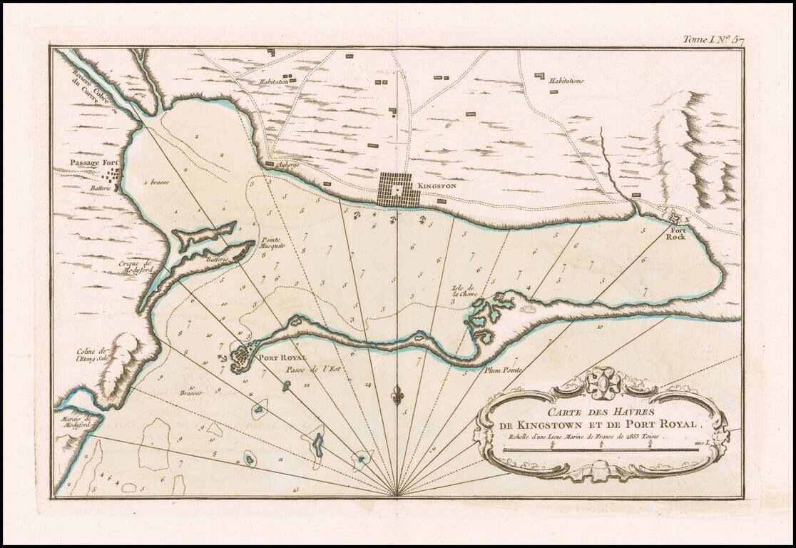
Kingston and Port Royal Harbor Fine original color example of this early chart of Kingston and Port Royal Harbor, which appeared in Jacques Nicolas Bellin's Petit Atlas Maritime. The map provides a fine early look at the region at the conclusion of...
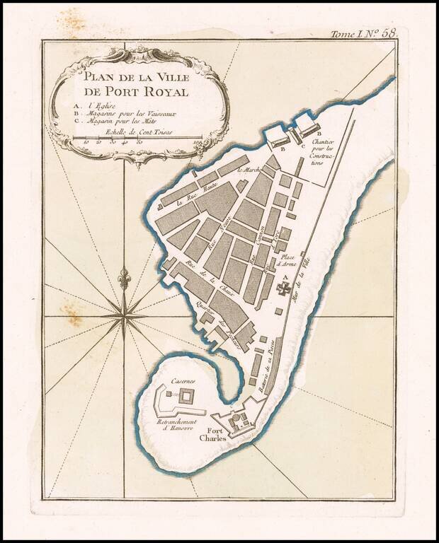
Port Royal Original color example of this early plan of Port Royal Harbor, which appeared in Jacques Nicolas Bellin's Petit Atlas Maritime. The map provides a fine early look at the region at the conclusion of the French & Indian War, a time...
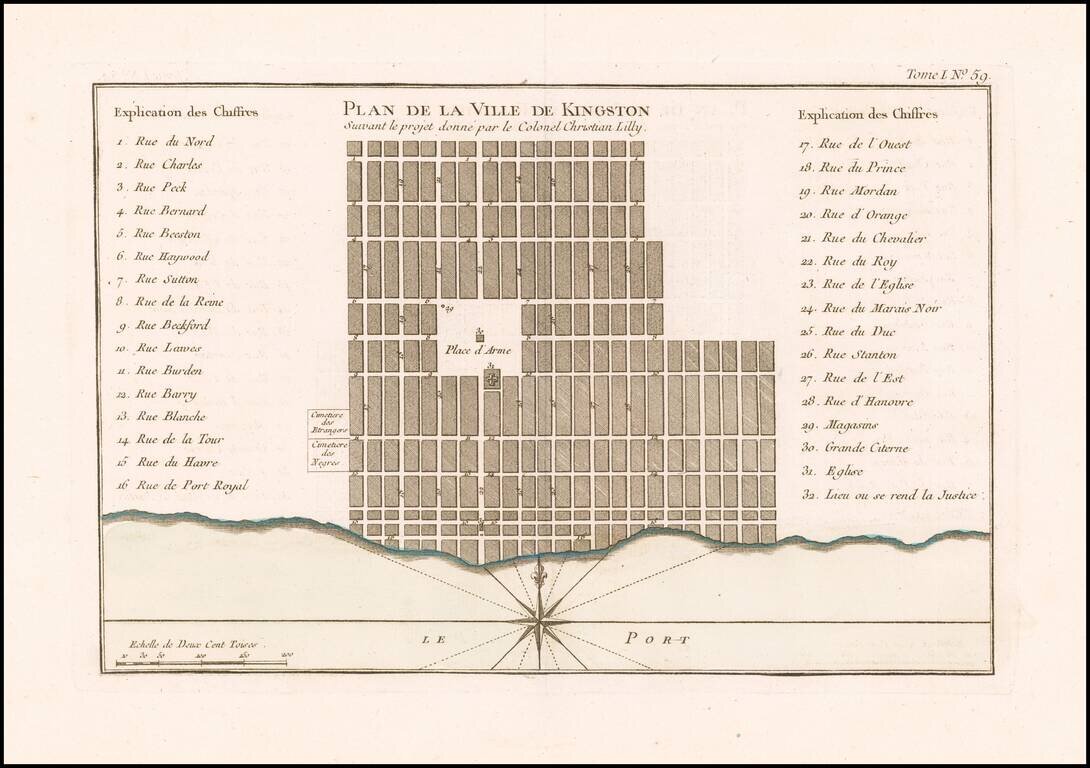
Early Plan of Kingston, Jamaica. Fine original color example of this early plan of Kingston, which appeared in Jacques Nicolas Bellin's Petit Atlas Maritime. The map provides a fine early look at the region at the conclusion of the French &...
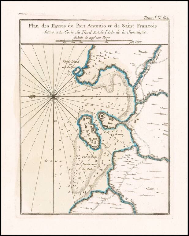
Port Antonio, Jamaica. Original color example of this early plan of Port Antonio and Navy Island, which appeared in Jacques Nicolas Bellin's Petit Atlas Maritime. The map provides a fine early look at the region at the conclusion of the French &...
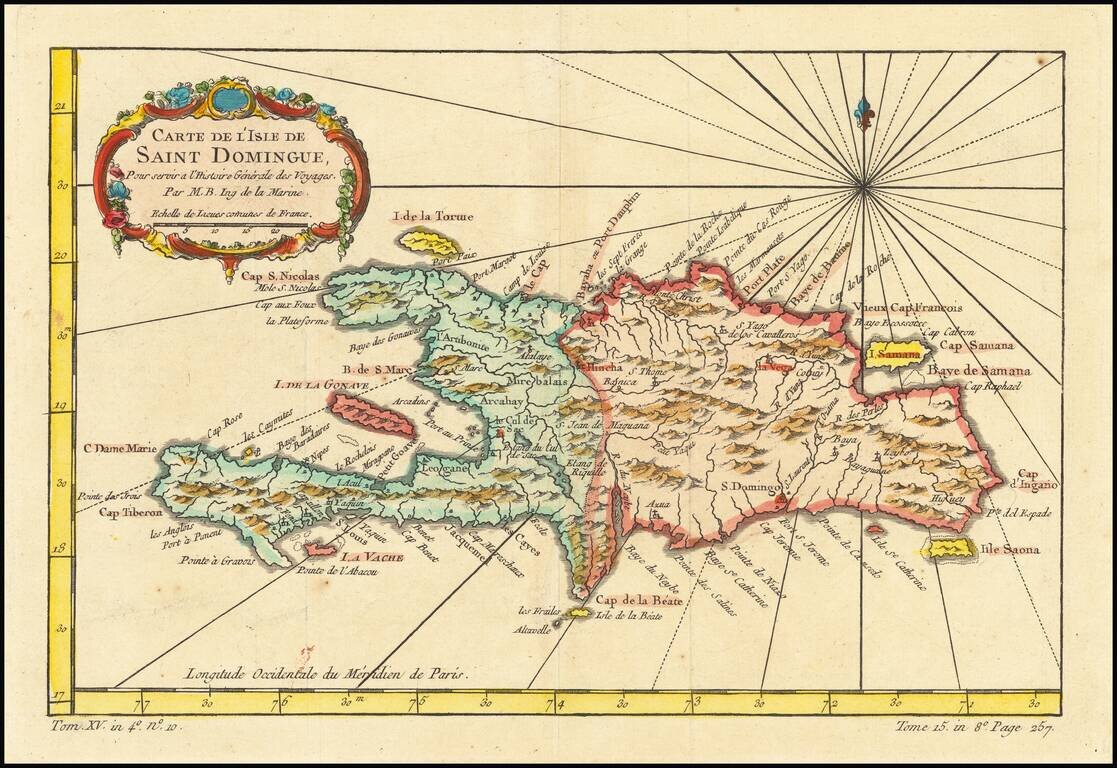
Detailed map of the Island of Saint Domingue. Remarkable detail for the period. Includes a large decorative title cartouche. One of the maps produced by Nichlas Bellin for Prevost d'Exiles influential travel book, L'Histoire Generale des Voyages.
![[Fort-Liberte Bay] Baye et Ville de Bayaha ou Port-Dauphin dans L'Isle S. Domingue](/map/small/59662.jpg)
Detailed map of the Bay of Fort-Liberte Santa Domingo, published in Nicholas Bellin's Petit Atlas Maritime. The chart is oriented with east at the top. Bellin was the first Ingenieur Hydrographe de la Marine, and also Official Hydrographer to the...
![[Port au Prince] Environs de Leogane et du Port au Prince dans L'Isle S. Domingue](/map/small/59730.jpg)
Detailed map of area around Port au Prince Bay in Haiti, published in Nicholas Bellin's Petit Atlas Maritime. The chart is oriented with southwest at the top. The plan shows the town, fortifications, anchorages, soundings, buildings, topographical...
![[Port au Prince] Le Port au Prince dans L'Isle S. Domingue](/map/small/59753.jpg)
Detailed map of Port au Prince Bay in Haiti, published in Nicholas Bellin's Petit Atlas Maritime. The chart is oriented with west at the top. The plan shows the town, fortifications, anchorages, soundings, buildings, topographical details, etc....
![[Petit Goave] Plan de la Rade et Ville du Petit Goave dans L'Isle S. Domingue](/map/small/59779.jpg)
Detailed map of area around Petit Goave Bay in Haiti, published in Nicholas Bellin's Petit Atlas Maritime. The chart is oriented with southwest at the top. The plan shows the town, fortifications, anchorages, soundings, buildings, topographical...
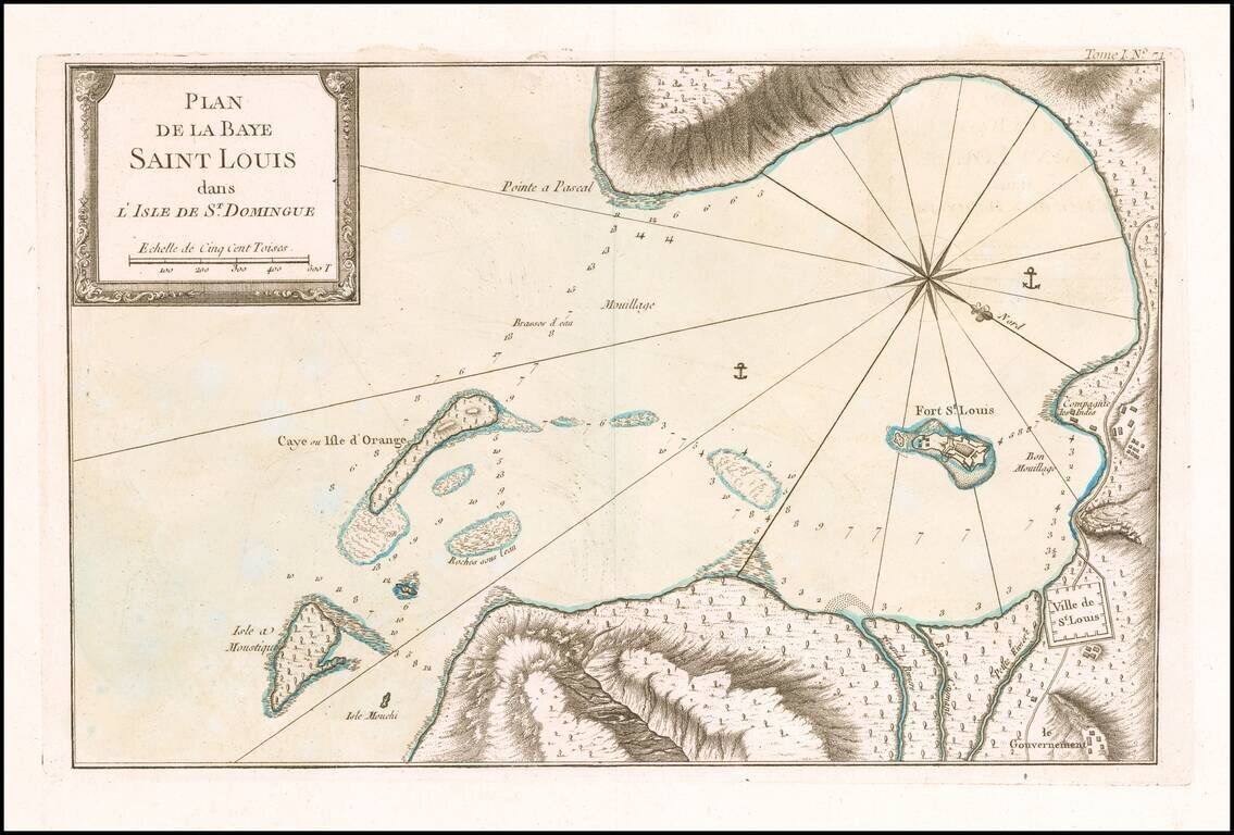
Detailed map of area around Saint Louis Bay, published in Nicholas Bellin's Petit Atlas Maritime. The chart is oriented with southwest at the top. The plan shows the town, anchorages, soundings, buildings, topographical details, etc. Bellin was the...

Detailed map of area on the southwest coast of Haiti, north of Ile a Vache, published in Nicholas Bellin's Petit Atlas Maritime. Bellin was the first Ingenieur Hydrographe de la Marine, and also Official Hydrographer to the French King.
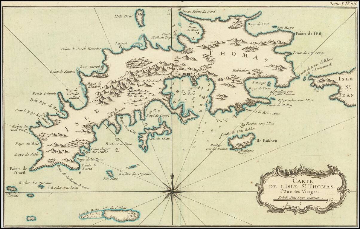
Striking map of St. Thomas, by Nicolas Bellin. Includes nice coastal and topographical detail and a decorative cartouche. There are relatively few separately issued maps of St. Thomas published in the 18th Century.