
Color printed invoice for Wm. H. Hoskins Co of Philadelphia. The Hoskins firm would remain in business as Stationers well into the 20th Century. At this point, the firm was advertising services as Engravers, Lithographers and Plate Printers, but also...

Satirical cartoon map, drawn by Tom Merry (William Mecham). The cartoon satirizes Liberal MP William Ewart Gladstone. Gladstone (1809-1898), served as Liberal Prime Minister four times and as Chancellor of the Exchequer. Gladstone opposed the High...

"One Of The Earliest and Most Complex Attempts" to Graph An American Presidential Election Detailed set of Political Maps, prepared to illustrate an article by T. Campbell-Copeland regarding the Presidential Election of 1888. The article title is...
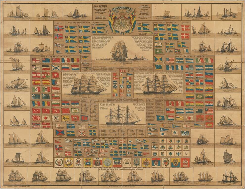
Scarce Swedish chart showing the flags of the World, published in Stockholm Toward the top, the maker illustrates a number of Swedish nautical flags, with the rest of the world's flags appearing below. Another section highlights signal flags of...
![[Map of the United States, illustrating the routes of the Candian Pacific Railway and the Seattle, Lake Shore and Eastern Railway]](/map/small/71080.jpg)
Interesting lithographed map of the United States and southern Canada illustrating the main railways emanating from Seattle, as well as the length of the Canadian Pacific. The map was issued in the 1888 Report on Washington Territory, along with a...
![[Original Artwork and Unique Lithograph] Sands Point Hotel Sands Point Long Island Sound Louis Berndt -- Propr.](/map/small/56027.jpg)
Original Artwork and Unique Lithographed View For A Gilded Age Hotel on Long Island. A superb pairing of original artwork and unique printed view for a Gilded Age hotel in the upscale neighborhood of Sands Point, Long Island. The lithograph features...
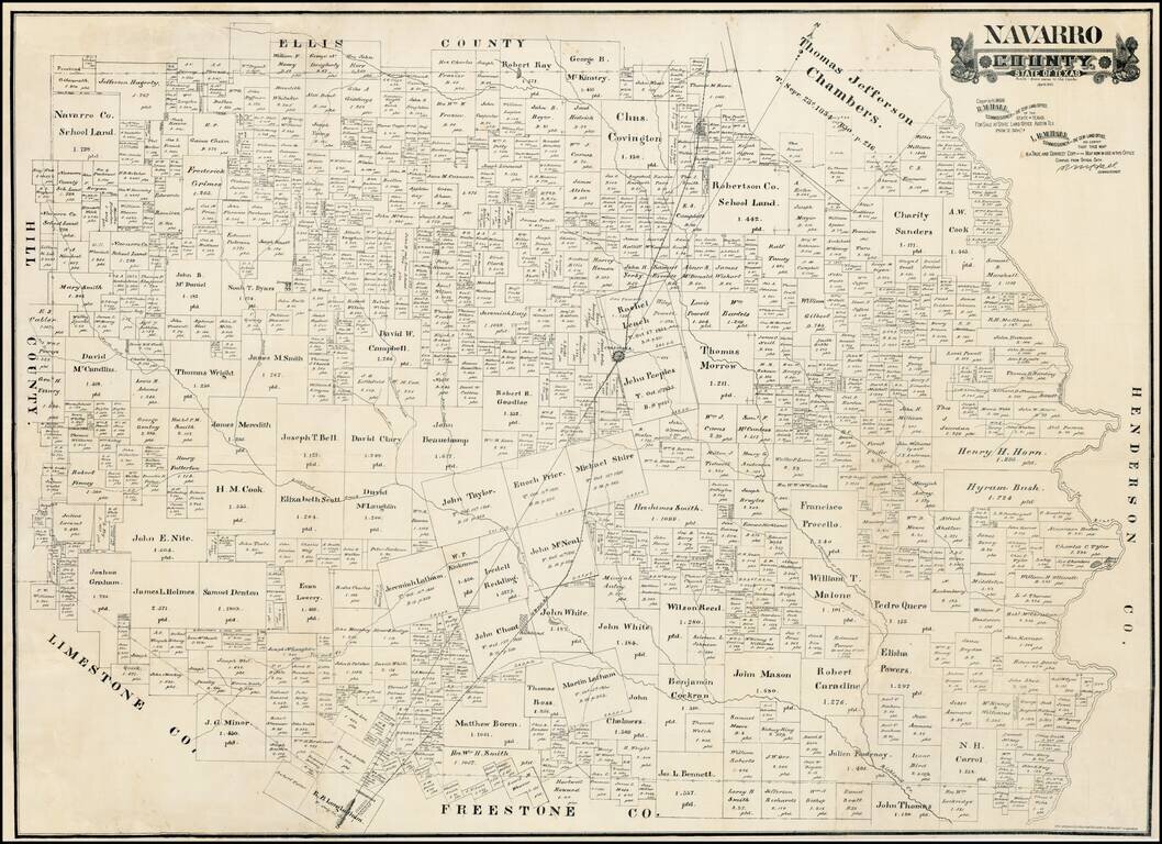
Some of the first Anglo groups to settle in the area were the families of John, Silas, and Ben Parker, all of whom helped build a fort near the site of present Groesbeck (Limestone County) in 1833. This fort was attacked on May 19, 1836, and all of the...
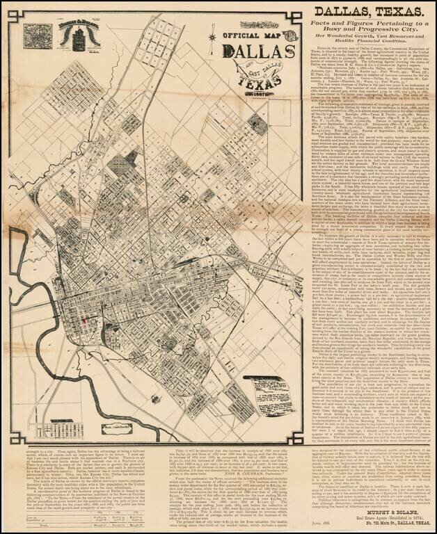
Extremely Rare - one of the earliest obtainable separately issued maps of Dallas, Texas, Murphy & Bolanz's highly detailed promotional broadside. This fascinating map is a promotional broadside, extolling the virtues of Dallas, Texas as "the...
![[State of Lincoln!] British Columbia and the North West Territory](/map/small/60287.jpg)
Rare separately published map of Western Canada and part of the Northern United States, including the proposed State of Lincoln. The map provides a detailed treatment of the Western part of Canada, along with a very rare appearance of the proposed...
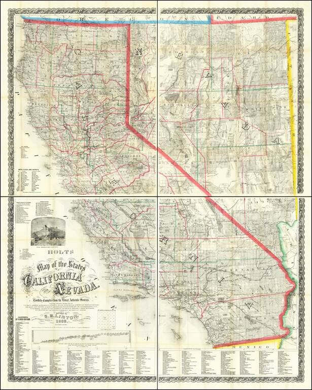
Mapping California and Nevada's Changing Watertable. Rare Late 1888 Edition of the Holt & Linton Map. Warren & Linton's rare and important antique map of California and Nevada, here in the late and substantially modified edition of 1888. In...
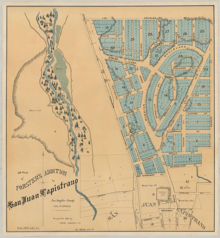
Earliest Printed Map To Detail The Mission San Juan Capistrano and Environs Rare plan of the Forster Addition, within the City of San Juan Capistrano, showing the Mission San Juan Capistrano and surrounding neighborhoods. The lands covered are those...
![[Los Angeles] Southern California. Scenes About Los Angeles.](/map/small/69098.jpg)
Rare double page color printed image of important places in the Los Angeles area, which appeared in The WASP magazine. The views include: The Belmont and Grounds, Summer & Winter Resort. Clark & Patrick Proprietors Philadelphia Brewery,...
![[Los Angeles and San Diego] Southern California. Scenes In and About Los Angeles.](/map/small/69136.jpg)
Rare double-page color-printed image of important places in the San Diego and Los Angeles area, which appeared in The WASP magazine. The views include: The Burbank Villa Hotel 10 Miles from Los Angeles New-United States Hotel Los Angeles Cal....
![[San Diego] Views of Southern California. Prominent Places in and about San Diego](/map/small/69182.jpg)
Rare double page color printed image of "Prominent Places" in the San Diego area, which appeared in The WASP magazine. The views include: Hotel Josephine (Coronado), with Coronado Railroad in the foreground Chadbourne's New Building (4th & C...
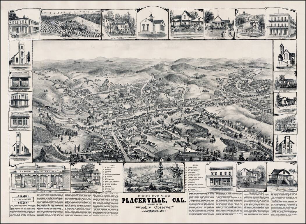
Rare view of Placerville, California, in the heart of California's Gold Country, by W. W. Elliott. Marvelous detailed plan of this important early California mining town sketched by L. Roethe, showing buildings, street names, topographical details,...
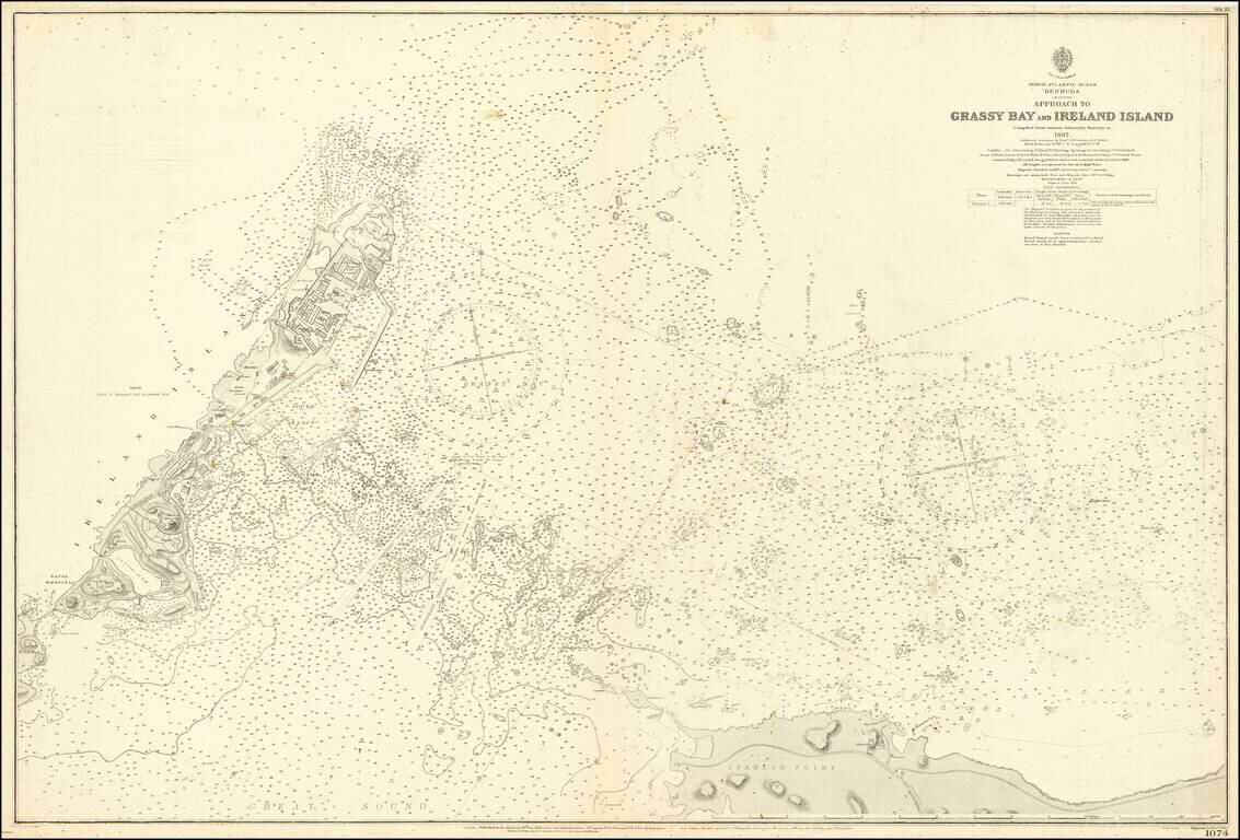
Detailed sea chart showing the approaches to Grassy Bay, Spanish Point, and Ireland Island in the Great Sound of Bermuda. The chart covers what is essentially the entrance to the "hook" of Bermuda, the Great Sound. Considerable detail is shown around...