Map size in jpg-format: 388.07MiB
Click to open in high resolution (open in new tab).

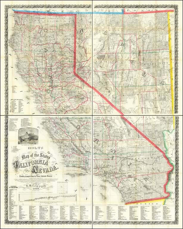
Mapping California and Nevada's Changing Watertable. Rare Late 1888 Edition of the Holt & Linton Map.
Warren & Linton's rare and important antique map of California and Nevada, here in the late and substantially modified edition of 1888.
In describing the 1869 edition of this map (of which there are two variant states), Carl Wheat identified the map as the best and most up to date map of both California and Nevada, stating that "no amount of time spent on this map would be wasted; its detail is fascinating. Constructed on a scale of 12 miles to the inch, the map is one of the largest maps of the region published to date and clearly the most detailed." Wheat notes that the map was in the style of the Army maps of the period, both in scale and in the inclusion of American Flags flying over military posts.
The 1869 map was updated a number of times to at least 1881 after which the lithographic stones were wholly redone. The maps printed from the later matrixes, such as this one, are far rarer than the 1869-1881 maps.
In previous editions of the map, the state capitol was shown above the title (in later editions with the capitol of Nevada and the University of California below the title); in this edition, the Lick Observatory has replaced it.
California Water
Holt and Linton turn more attention to California's lakes and rivers in this map than in previous editions; in the Central Valley, they map the extent of Lake Tulare in 1855, 1880, and 1888, as it dramatically shrank with the passing years. There they also show Buena Vista Lake and Kein Lake shrinking away. In Southern California, they illustrate many dry lake beds throughout the desert, including a particularly large one that would later become the Salton Sea.
Rarity
Rare. One copy recorded in OCLC (Stanford) and one copy only in OldMaps and RBH (Warren Heckrotte's copy sold in 2016, also in unjoined sheets.)
If you are a student, write to us in telegram: @antiquemaps and indicate what material you need and for what work you need a map in high detail. We are ready to provide material on special terms. For students only!

![Mexique par Th. Duvotenay…1843 [Republic of Texas]](/map/small/67925.jpg)
