Rare old maps of the whole world. Secret knowledge, ancient worlds, ancient maps - discover the ancient world
![[English Edition!] Maris Pacifici quod vulgo Mar del Zud](/map/small/71000.jpg)
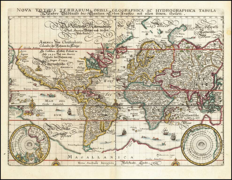
Rare English Edition of The First Map of the Pacific Ocean from the First Modern Atlas Fine example of the English Edition of Ortelius' “Maris Pacifici”, the first stand-alone map of the Pacific ever printed. It was featured in Theatrum Orbis...
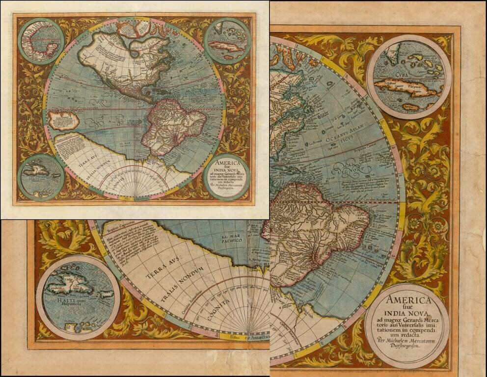
Striking Example of Michael Mercator's Map of the Western Hemisphere, the Only Map he Ever Engraved This is a fine example of Mercator's map of the Western Hemisphere, based upon Rumold Mercator's world map of 1587. Fascinatingly, this is the only...

Scarce Variant of Blaeu's Map of the Americas This is a decorative example of Blaeu's map of America, one of the most sought after maps of the continent from the Golden Age of Dutch Cartography. The map blends contemporary geographical knowledge with...
![[Wall Map] West-Indische Paskaert waer in de graden der breedde over weder zyden vande middelyn wassende so vergrooten dat die geproportioneert syn tegen hunne nevenstaende graden de lengde.](/map/small/60169.jpg)
A Remarkable Dutch Sea Chart Used For Navigation Between Africa and America Rare Johannes Van Keulen issue of Pieter Goos's sea chart of the Atlantic Ocean, America and Africa, first published circa 1680. This chart was created for use at sea by...

Fine example of Pierre Mortier's map of the Pacific, which appeared in later editions of the famous Neptune Francois This fine map of the Pacific was drawn from previously unpublished manuscript maps collected by the Portuguese crown and secreted away...
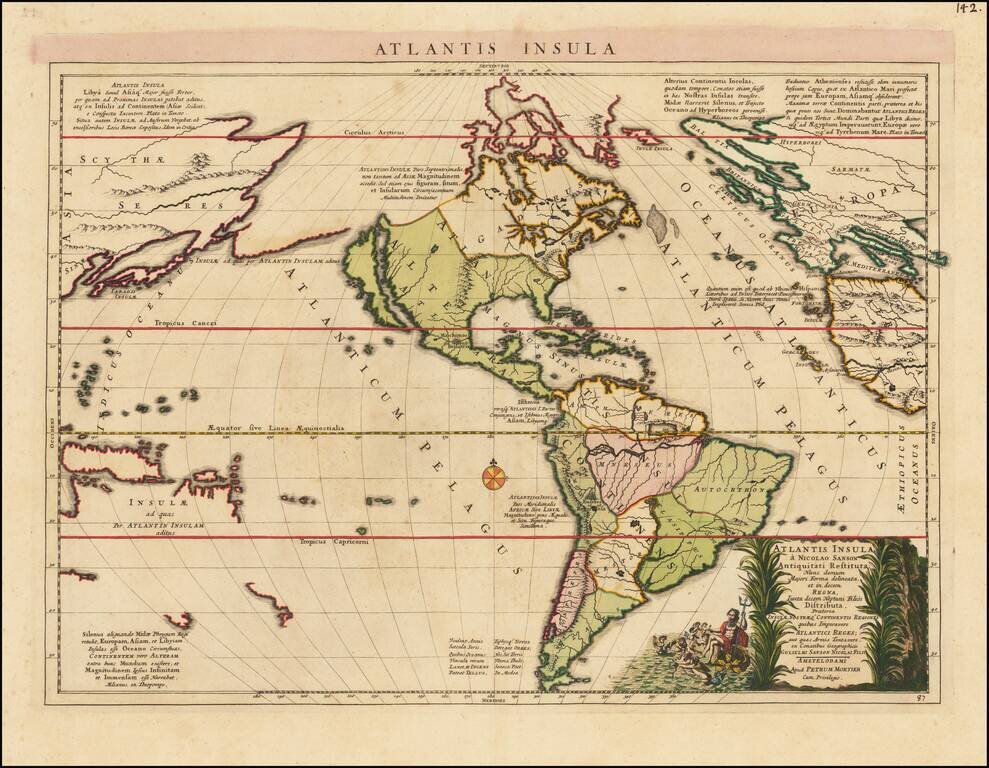
Fascinating map of America, published by Mortier and based upon a map by Nicolas Sanson, purporting to show the Western Hemisphere about 200,000 years ago before the earliest human civilizations. The map reflects the populating of the lost continent...

Rare map of the Western Hemisphere in mirror image format, from a very rare work by Pierre Moullart Sanson, the grandson of Nicolas Sanson the Elder. The map is part of a series of maps intended to depict the various ways of depicting the Globe. The...
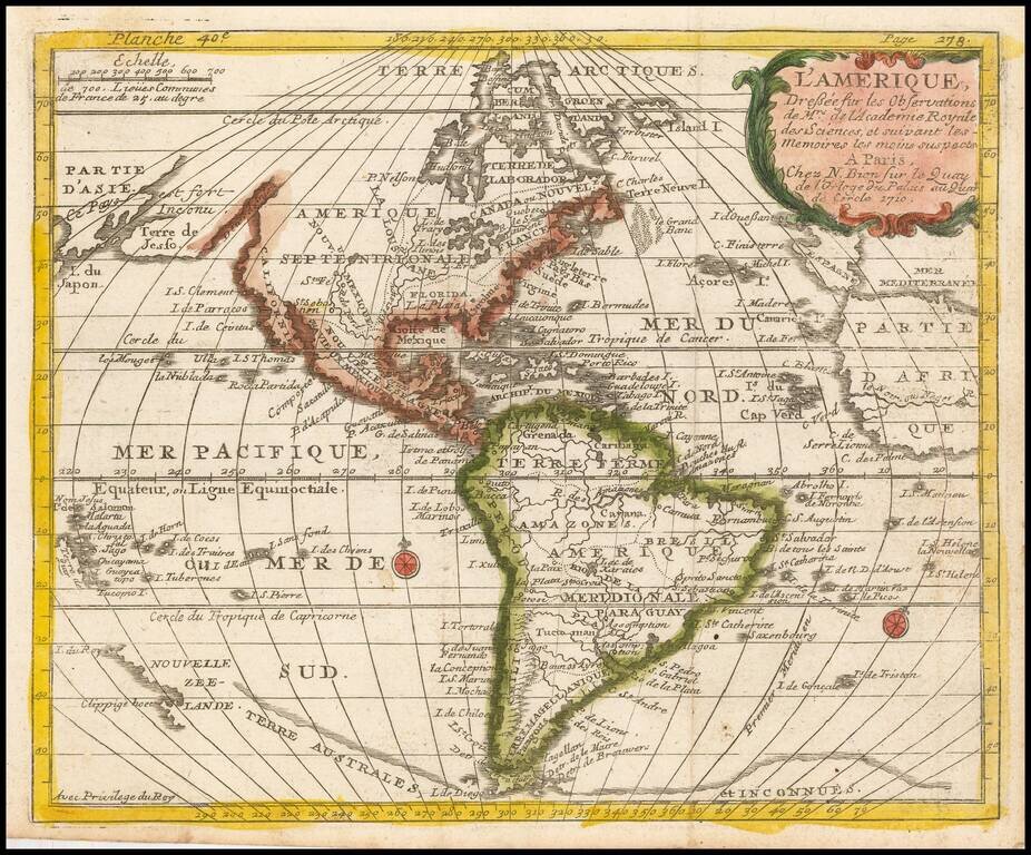
Scarce map of America with a fascinating treatment of the Northwest Coast of America. The map shows a very unusual "est fort Inconu" and "Terre de Jesso," a curious marriage between the treatment of the region from the mid-17th century and more...

Early Four-Sheet Sea Chart of the Atlantic Ocean Scarce and detailed early eighteenth-century English set of sea charts of the Atlantic Ocean, with a fine, large inset of the area between the Hudson River and the mouth of the Chesapeake Bay. The...
![[Western Hemisphere]](/map/small/70708rd.jpg)
Finely-Drawn Eighteenth-Century Manuscript Map of the Western Hemisphere Carefully-constructed, single-hemisphere manuscript map of the Americas, signed by Michael Rampf. Oceans, continents, and cartographic elements such as the equator, tropics, and...

Scarce map of the Western Hemisphere, with California as an Island. Issued in his: Orbis Sensualium Picti Pars Prima ... Norimbergae : In Bibliopolio Joh. Andr. Endt. Anno Salutis, MDCCLXXXI (1777). Orbis Sensualium Pictus, a school geography, was...

Unrecorded map of the Western Hemisphere Printed on Linen Finely executed map of the Western Hemisphere, printed on linen. The map depicts the Western Hemisphere on a stereographic projection, centered on a point in the Pacific. The notable...
![[Atlantis?] Ristretto Delle Carte presentate all' Academia delle Scienze di Parigi negli anni 1737 e 1752 dal Sig di Buache](/map/small/58667.jpg)
The First Americans Came To America via the Lost Continent of Atlantis?—Rare Italian Map from Work on the Origins of Americans Utilizing The Theories of Philippe Buache Very rare, Italian example of Buache’s theoretical geographic ideas on...
![[New General Map of North and South America Showing the Routes of Kruzenshtern and Lisyansky] НОВАЯ ГЕНЕРАЛЬНАЯ КАРТА СѢВЕРНОЙ И ЮЖНОЙ АМЕРИКИ СЪ ПОКАЗАНІЕМЪ ПУТЕЙ КРУЗЕНШТЕРНА И ЛИСЯНСКАГО](/map/small/58490.jpg)
A Superb Russian Map of the Americas, Made to Highlight the Explorations of Kruzenshtern and Lisyansky in the Pacific. In Alaska, the map notes Lisyansky's landfall on Kodiak Island and at New Archangel (Новоархангелѣскъ, i.e.,...
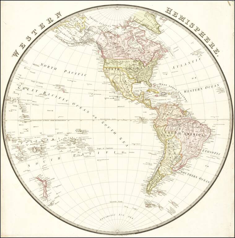
Nice map of the Western Hemisphere, published in London by Wyld. South America appears at the height of its Revolutionary period, where Spain and Brazil were losing their colonies. The Newly independent Mexico is shown, with Adams-Onis Treaty...
![Western Hemisphere [and] Eastern Hemisphere](/map/small/46484.jpg)
Nice full color example of these highly decorative maps of the Western Hemisphere and Eastern Hemisphere, each with 12 decorative vignettes. Perhaps the most decorative mid 19th Century Atlas map of its type. Engraved for R. Montgomery Martin's...