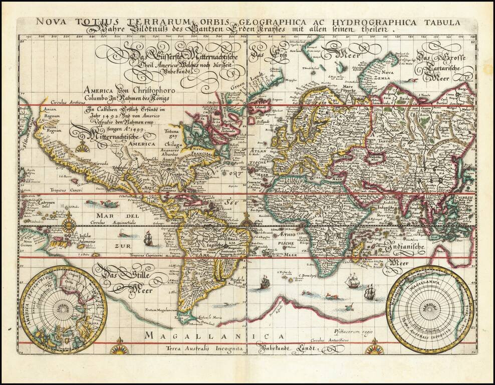
Rare old maps of the whole world. Secret knowledge, ancient worlds, ancient maps - discover the ancient world

"A scientific and artistic document of the first order" -- One of the most important sea charts of the 17th century. Exceptionally rare Johannes Loots issue of Guillaume Blaeu's landmark sea chart of the Atlantic Ocean, America and Africa, printed on...
![[Martin Behaim Globe / Book] Pars Globi terrestris Ao. 1492 a Martino Behaim Equite Lusitano Norimbergae confecti Delineavit Christoph. Theoph de Murr 1778 (bound with:) Diplomatische Geschichte des Portugesischen berühmten Ritters Martin Behaims](/map/small/68828.jpg)
Behaim's Discovery of America -- Engraved Map Depicting a Section of Martin Behaim's Globe of 1492, Oldest Globe in the World -- Bound With Book on Martin Behaim Extremely rare map illustrating the "western" section of Martin Behaim's globe of 1492,...

The Earliest Obtainable Map To Show Houtman's Crossing of the Indian Ocean to the Java, Opening The Spice Trade to The Dutch in 1597. Finely engraved map, showing the route of first Dutch fleet from Zuider Zee to Java in 1596-97, under the command of...

Whimsical map depicting the route of the USS Independence, from Norfolk to the Arabian Sea. On November 19, 1980, the USS Independence deployed to the Indian Ocean along with the Harry E. Yarnell (CG-17) and was on watch along with the Ranger on...
![Pascaart vertoonende de zeecusten van Chili, Peru, Hispania Nova, Nova Granada, en California…. [Early New Zealand Inset]](/map/small/65168.jpg)
Fine Golden Age Dutch Chart with the Island of California and an Early Mapping of New Zealand Scarce early sea chart by Doncker, showing the West Coast of the Pacific Ocean, which extends from the island of California to Chile, with noteworthy insets...

Antique Map of the Old World Nice full color example of Covens & Mortier's map of the Eastern Hemisphere, showing Africa to Japan and down to Australia. Nice interesting treatment of Australia.
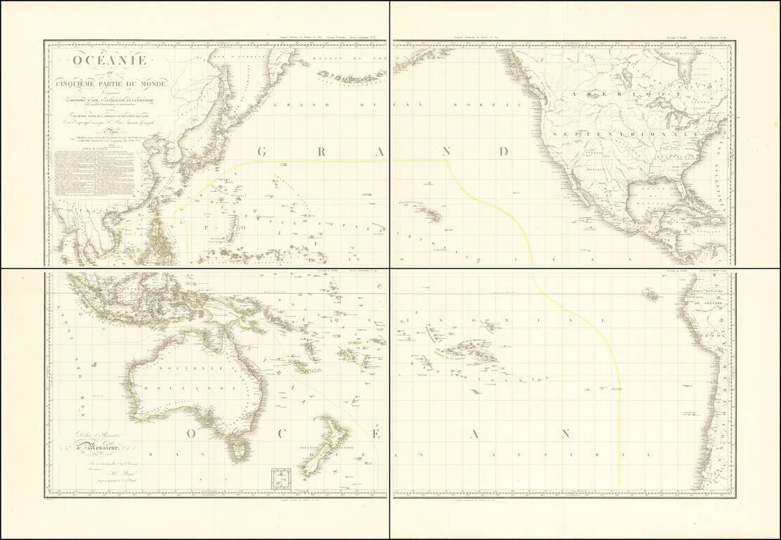
Stunning, Large-Format Map of the Pacific, the Origin of the Toponym Oceania Fine example of A.H. Brué's four-sheet map of the Pacific Ocean, first published in Paris in 1814 and here updated to 1817. The title in the upper left corner indicates...
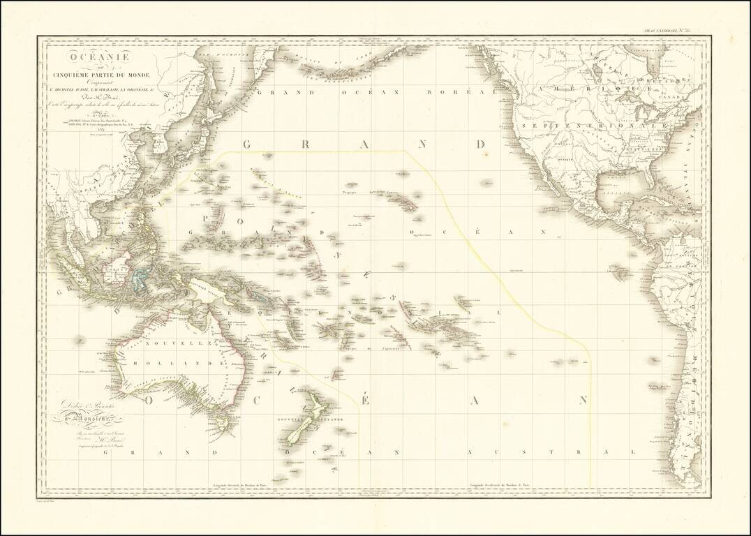
Striking Map of the Pacific, the Origin of the Toponym Oceania Fine example of A.H. Brué's distinctive map of the Pacific Ocean, first published in Paris in 1814 and here updated to 1816. The title in the upper left corner indicates that this map...
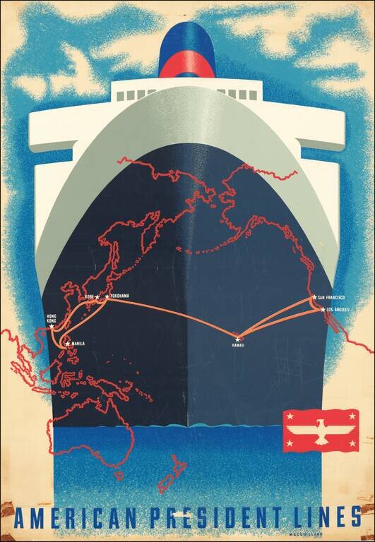
A San Francisco native, Macouillard was an accomplished artist, having studied at the California College of Arts and Crafts and the Art Students League of New York. He became Art Director of the Velvetone Poster Company in San Francisco and designed...

Fine example of Cellarius's chart illustrating Tycho Brahe's unique geo-heliocentric model of the universe, first published by Jan Jansson in 1660 and re-issued in 1708 by Schenk & Vallk. In the late 16th century, Tycho Brahe, an important Danish...
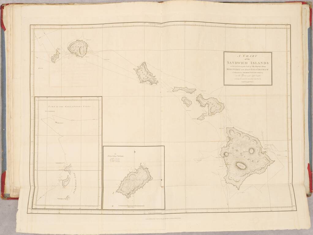
First Edition of Vancouver's Voyage of Discovery with Atlas, Containing Influential Charts of Hawai’i and the Pacific Northwest Fine, complete four-volume set of Vancouver’s A Voyage of Discovery to the North Pacific Ocean, and Round the World...
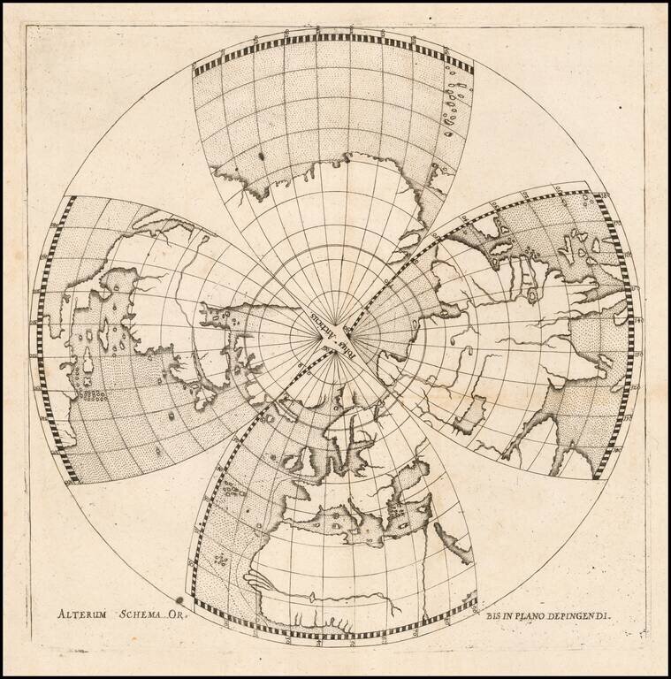
Unusual Seventeenth-Century Projection of the Northern Hemisphere Highly unusual gore map of the Northern Hemisphere by German minister, mapmaker, and surveyor Daniel Angelocrator, employing a projection apparently of his own invention or adaptation....
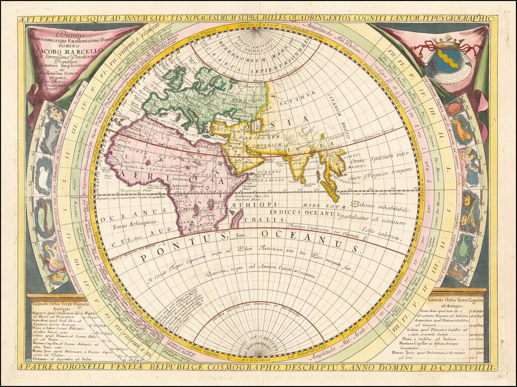
Fine example of Coronelli's map of the Old World, dedicated to Jacobo Marcello. Coronelli bases his map on classical geography, as known at the time of Ptolemy, Strabo and Mela, covering most of Africa and the Indian Ocean, but no Japan or China or NE...
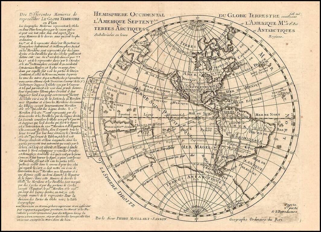
Rare map of the Western Hemisphere, from a very rare work by Pierre Moullart Sanson, the grandson of Nicolas Sanson the Elder. The map is part of a series of maps intended to depict the various ways of depicting the Globe.
![[Proietio Optica Hemisphaerii Polaris Arctici]](/map/small/59287.jpg)
Unusual World map on a North Polar projection, with a highly enlarged depiction of Greenland and Iceland and celestial model in the upper right. The map shows California as an Island and a potential NW Passage and also a possible continuous landmass...
![Planisphere Physique ou l'on voit du Pole Septentrional ce que l'on connoit de Terres et de Mers Avec les Grandges Chaines de Montagnes . . . [Bay or Sea of the West]](/map/small/70578.jpg)
Scarce Buache Map of the World's Watersheds, One of the First Thematic Maps Fine example of Buache's watershed map of the world, on a North Polar projection. The map shows how mountain chains affect the flow of water into the various oceans. The map...