
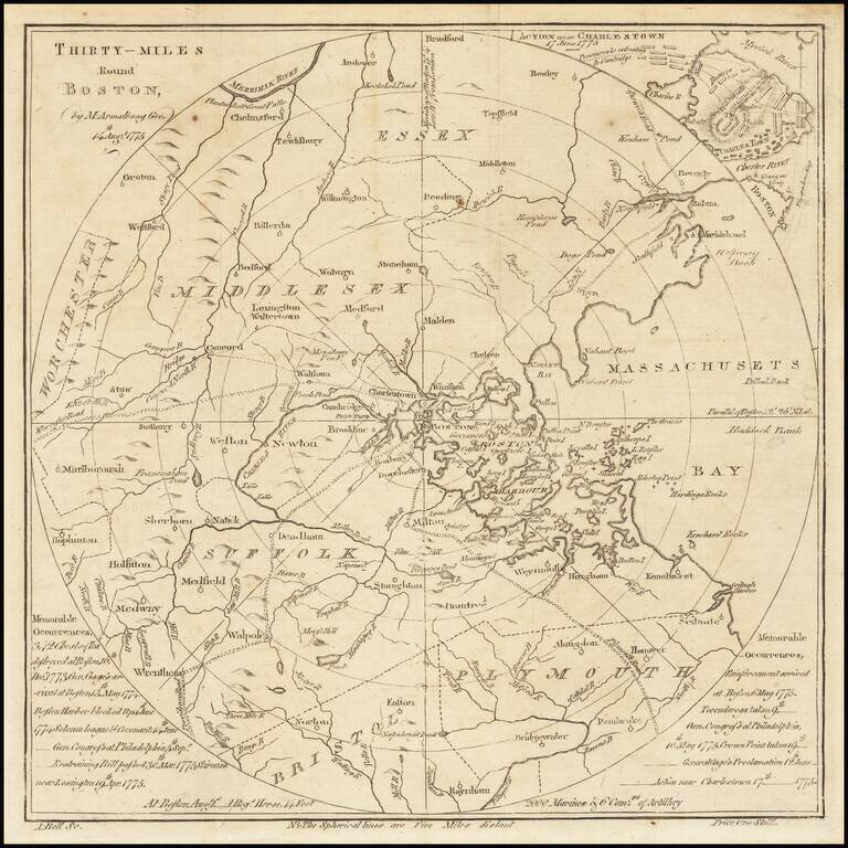
One of the Very First American Revolutionary Maps and Battle Plans. Including a Reference to the Boston Tea Party. An unusual map of the Theater of War in Massachusetts, centered on Boston, which appeared in the Scots Magazine in 1775. The circles...
![[Massachusetts Bay, with Boston and Part of Cape Cod]](/map/small/59282.jpg)
Exceptional Revolutionary War Era Chart of Massachusetts Bay. One of the better charts from Des Barres' Atlantic Neptune, extending from Cape Ann in the north, through Boston, to Plymouth in the south, and showing Cape Cod from Wellfleet north. This...
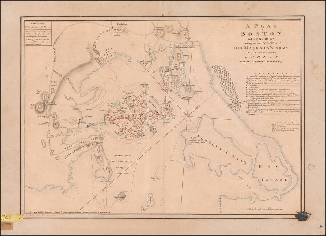
An Early Revolutionary War Battle Plan From An German Archive Nice example of perhaps the finest contemporary plan of the Siege of Boston at the outset of the American Revolution, drawn by Lieutenant Richard Williams. Williams' remarkable...
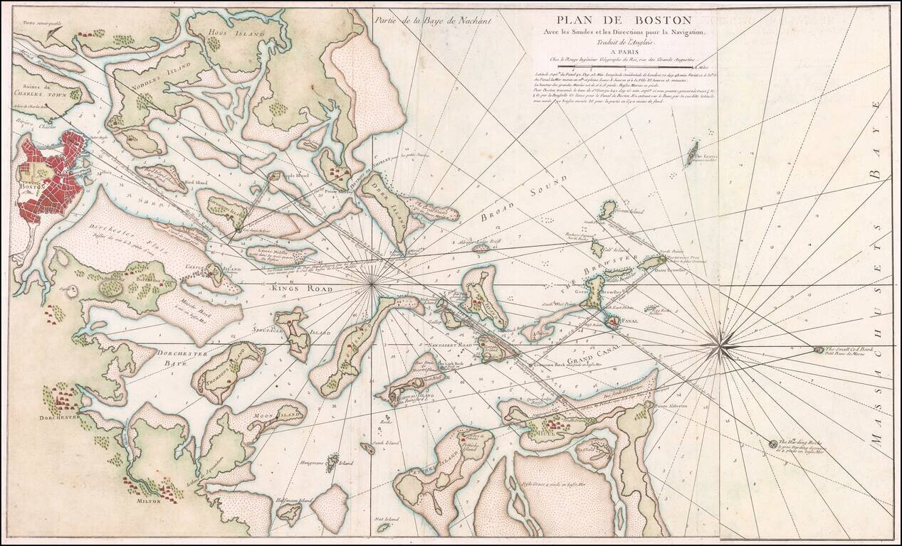
Rare French edition of Sayer & Bennett's rare chart of Boston Harbor revised and issued in Le Rouge's Pilote Americain Septentrionale, which was compiled specifically for use by the French Navy during the American Revolution. A note following the...
![[Boston] Carte Particuliere Du Havre De Boston . . . 1780](/map/small/61227.jpg)
Boston & Environs During The American Revolution Finely hand-colored example of this scarce Revolutionary War era plan of Boston Harbor, issued by the Depot General des Cartes, Plans et Journaux de la Marine, based on Des Barres' chart of Boston...
![[Plymouth Bay, Cape Cod Bay, Duxbury Bay]](/map/small/51249.jpg)
Des Barres Chart of Plymouth Bay, Cape Cod Bay and Duxbury Bay Fine detailed sea chart of the area around Plymouth and Duxbury, Massachusetts, and covering Cape Cod Bay, Duxbury Bay and Plymouth Bay, published in London by Des Barres. The map shows...
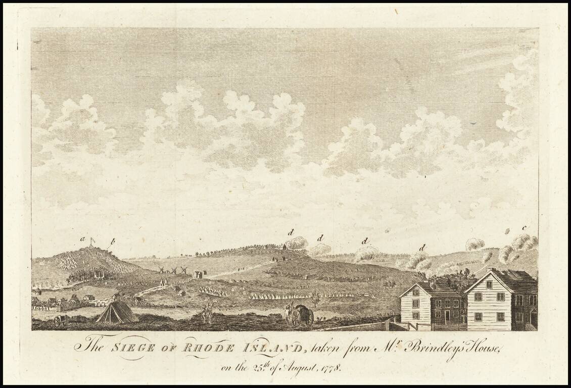
The Battle of Rhode Island was the only battle in New England to occur between the Continental army and the British army. Fought to dislodge the 7,000 British, Hessian, and provincial troops from their entrenched position in Newport during the month...
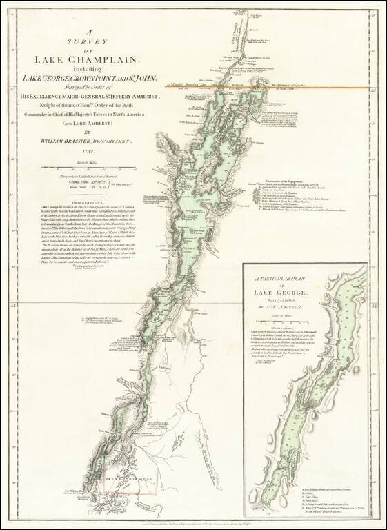
An Important Revolutionary War Period map of Lake Champlain & Lake George, based upon William Brassier's survey of the region during the French & Indian War. Sayer & Bennett's map is the first separately published map to focus on Lake...
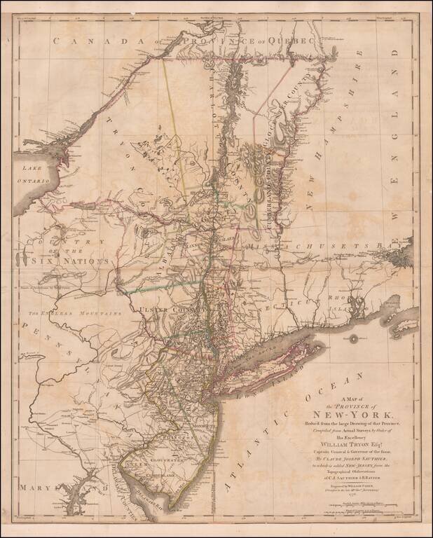
Important early Revolutionary War map, published by William Faden shortly after the signing on the Declaration of Independence. This remarkable map is a combination of two of the most important colonial surveys conducted on the eve of the Revolution,...
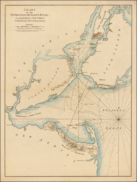
First state of this rare sailing chart of the area around New York Harbor and Long Island, which was issued separately and in the first edition of Sayer & Bennett's North American Pilot. This finely detailed chart is centered on Staten Island,...
![[A chart of New York Island & North River: East River, showing passage through Hell Gate, and the North Shore of Long Island: Flushing Bay, Hampstead Bay, Oyster and Huntington Bay, Cow Harbor]](/map/small/51531.jpg)
Des Barres's rare general chart of New York and Long Island Sound. Large hand-colored engraved chart of New York City and the water route from New York Harbor to the middle of Long Island Sound, by way of the East River. Des Barres's map was the...
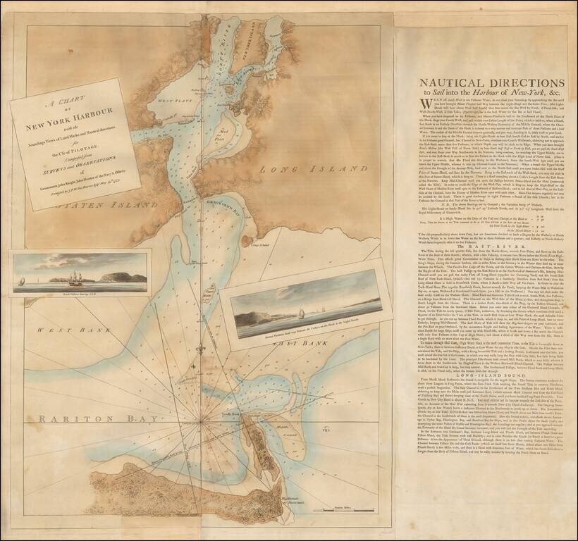
Des Barres's Map of New York Harbor. The Definitive Revolutionary War Era Chart of the Harbor. Highly important Revolutionary War Era chart of New York Harbor, published in the most important collection of nautical charts of the age: Des Barres's...
![[Long Island & Vicinity] Der Teufels Belt gemeiniglich genannt der Lange Insels Sund](/map/small/37902.jpg)
Extremely rare separately printed map of Long Island, New York City and the area north of the City and Long Island. Includes the contiguous Connecticut Coastline to just beyond Stonington Bay and Fisher's Island and to just north of Tappen Zee and...
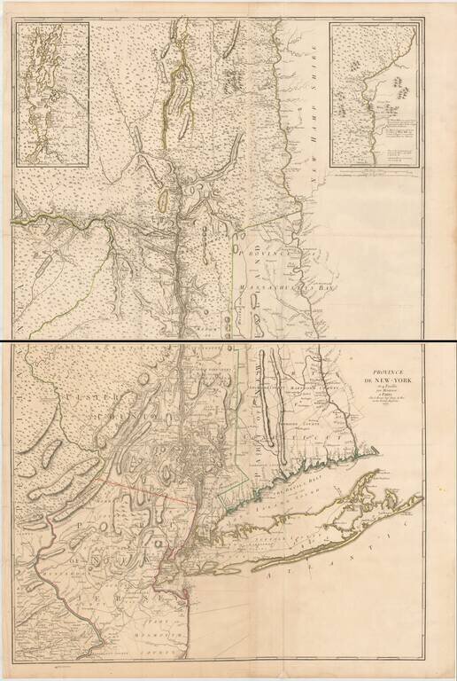
The Most Important Map of The British Colony of New York on the Eve of the American Revolution, With Revisions Added By The French For Use During the American Revolution. Fine example of the George Louis Le Rouge edition of John Montressor's...
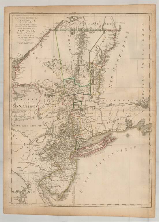
Rare French edition of this important early Revolutionary War map, published to illustrate the Northern Theater of War in the early years of the American Revolution, shortly after the French entered the conflict in alliance with the American...
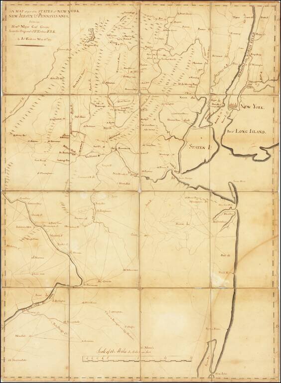
One of a Few Surviving Manuscript Maps Made For The Continental Army To Remain in Private Hands Large manuscript map of northern New Jersey and southern New York (including New York City), “the cockpit of the American Revolution”, drawn by John...