
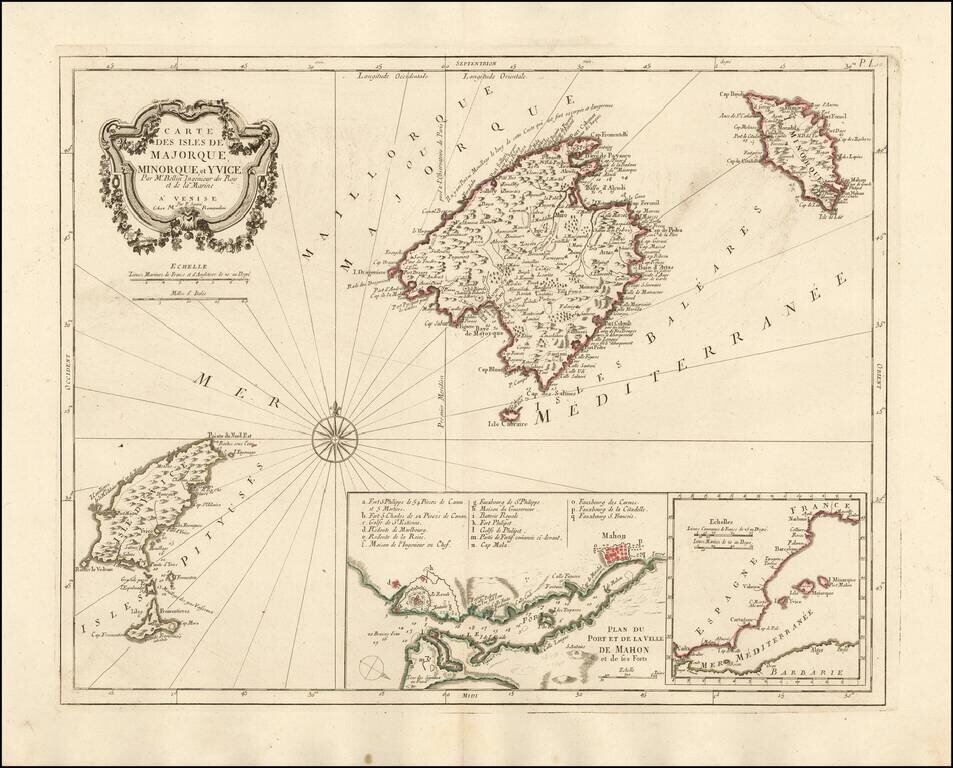
Nice example of the Paolo Santini edition of Nicolas Bellin's map of the Balearic Islands. Includes a map of Mahon Harbour and the position of the islands against the coast of Spain. A fine highly detailed map of Majorca, Menorca and Ibiza.
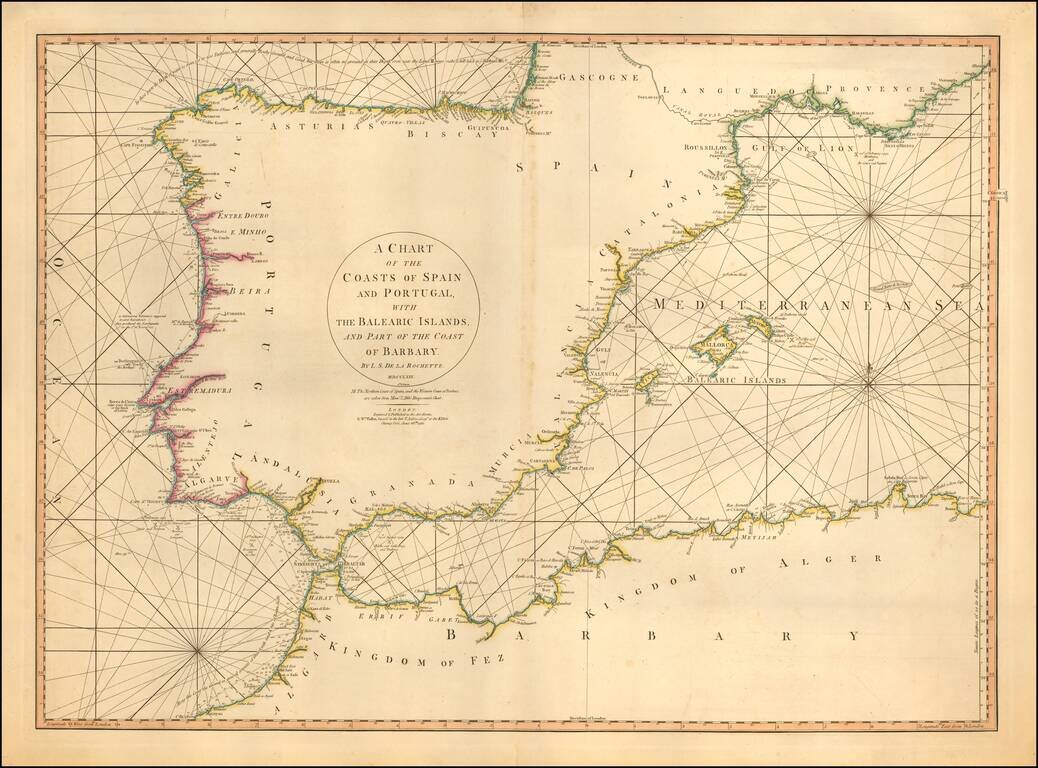
Detailed sea chart of the Balearic Islands, Spain, and Portugal. The chart extends to Provence and much of the Barbary coast to Bona. Good detail along coastal areas including the Straits of Gibraltar.
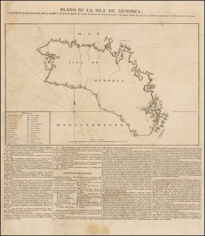
Spanish Broadside Map of the 1781-82 Conquest of Menorca. Rare separately issued broadside map showing information related to the Conquest of Menorca in February, 1782. The map shows the support provided by the Spanish in aid of the Duke of Crillon,...
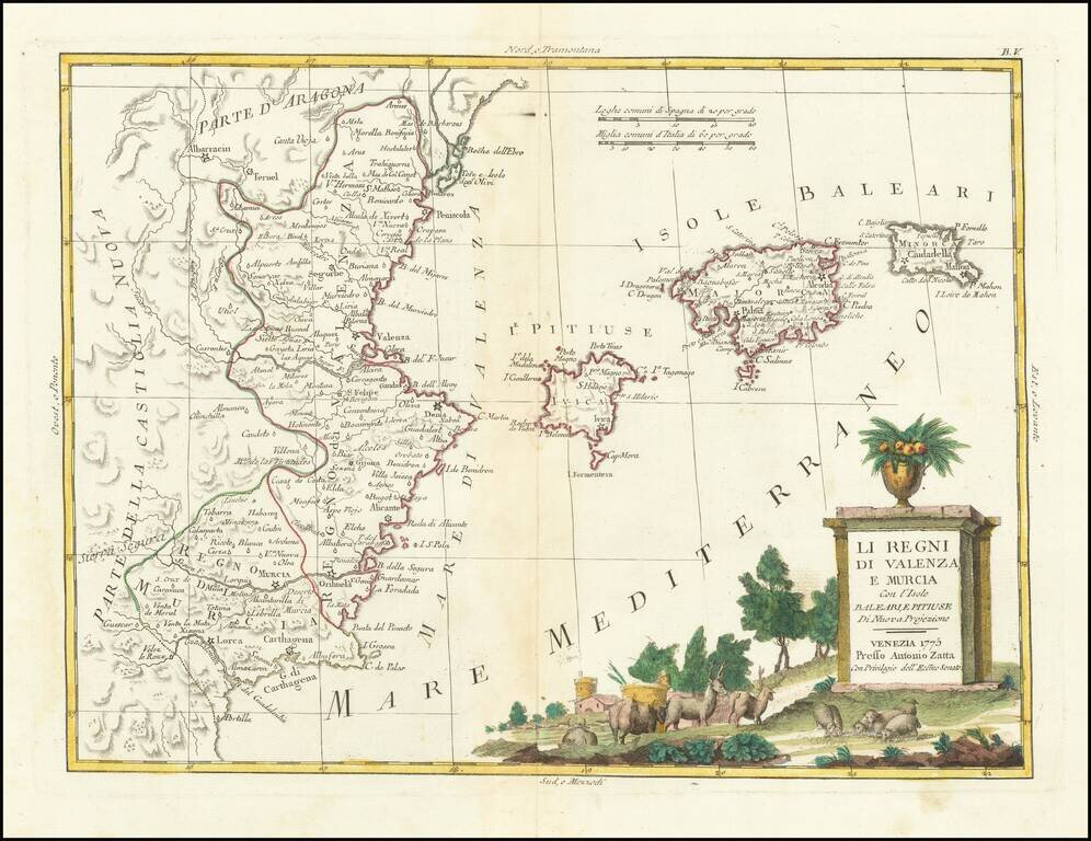
Detailed map of the eastern coastline of Spain, centered on Valencia, Murcia and the Balearic Islands of Ibiza, Minora and Majorca. Very interesting early map, with nice detail. Decorative title cartouche. From Zatta's monumental Altante Novissimo,...
![Spain and Portugal, with Their General Divisions . . . [Balaeric Islands]](/map/small/65193.jpg)
Detailed late 18th Century map of the Iberian Peninsula and contiguous islands. Scarce English language map of the region. From Dunn's New Atlas or Mundane System of Geography.
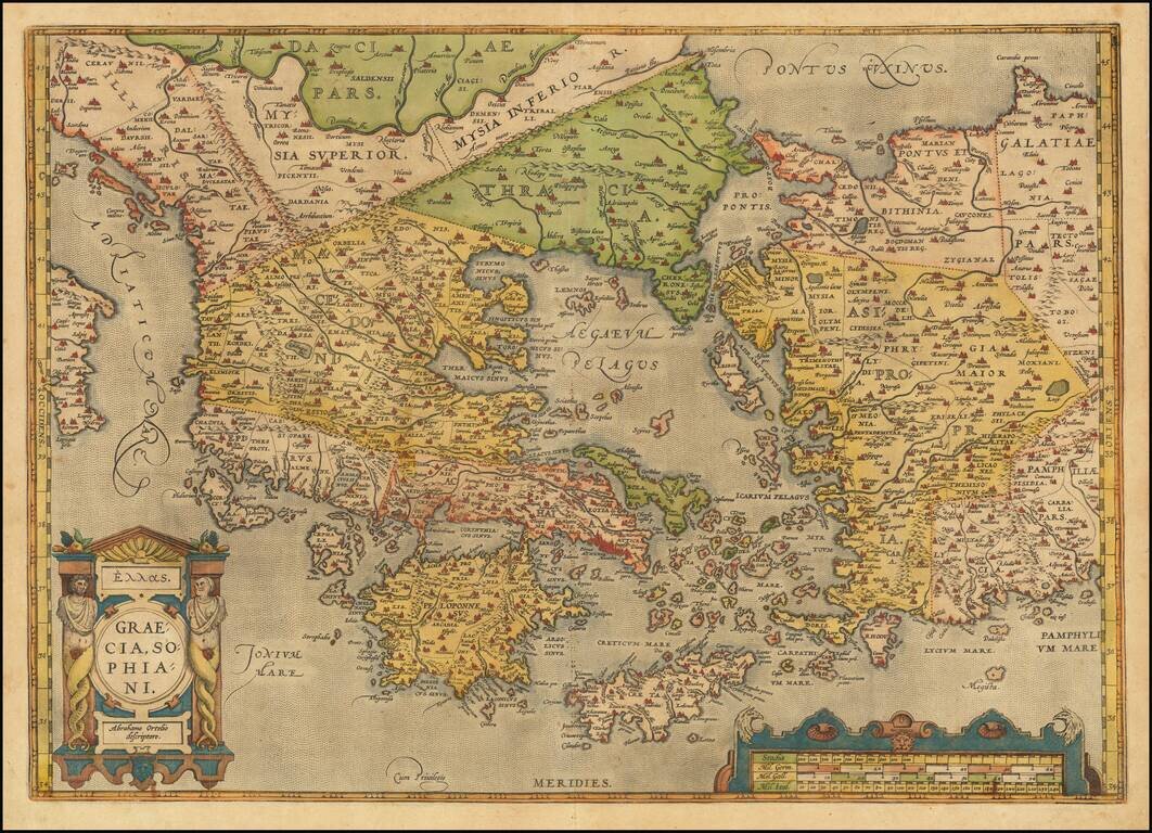
Old color example of Ortelius' decorative map of Greece, Turkey and Asia Minor, with neighboring islands, from Ortelius' Theatrum Orbis Terrarum, the first modern atlas of the world. The map is embellished by a decorative cartouche and scale of miles....
![L. Rouwolfs Reys-Togten, door de Levant, of Oosterse Landschappen der Middellandse Zee [shows Cyprus]](/map/small/55336.jpg)
Interesting map of the Mediterranean region, showing Leendert Rouwolf's route from France to Tripoli. Includes decorative cartouche.
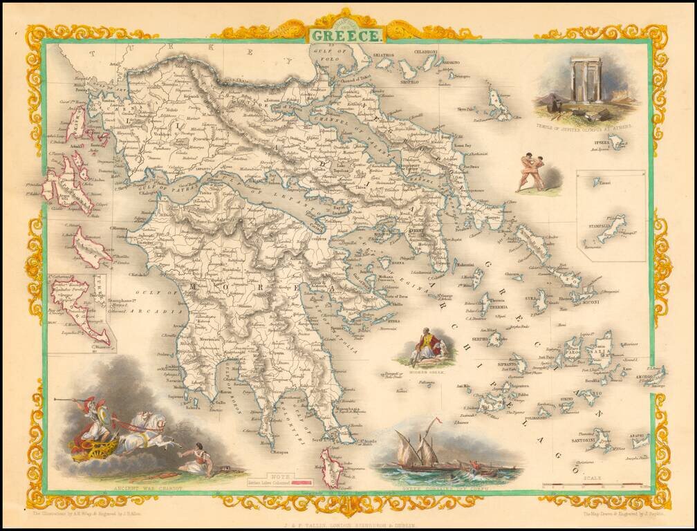
Decorative color example of this marvelous map. Decorative vignettes of an ancient war chariot, Temple of Jupiter on Mt. Olympus, Greek Corsairs off Corfu, a modern Greek and wrestlers. Engraved for R. Montgomery Martin's Illustrated Atlas. Tallis was...
![Natolia, quae olim Asia Minor [shows Cyprus]](/map/small/71119.jpg)
Fine original hand-color example of Blaeu's decorative map of Asia Minor, showing Turkey, Cyprus and the Islands in the Aegean. This attractive map shows all of Turkey, Cyprus, and the Aegean Islands to a relatively high degree of accuracy. At the...
![Natolia, quae olim Asia Minor [shows Cyprus]](/map/small/40634.jpg)
Jan Jansson's decorative engraved map of Asia Minor, showing Turkey, Cyprus, and the Islands in the Aegean. This attractive map shows all of Turkey, Cyprus and the Aegean Islands to a relatively high degree of accuracy. At the time the entire region...
![Turcicum Imperium . . . [shows Cyprus]](/map/small/69623.jpg)
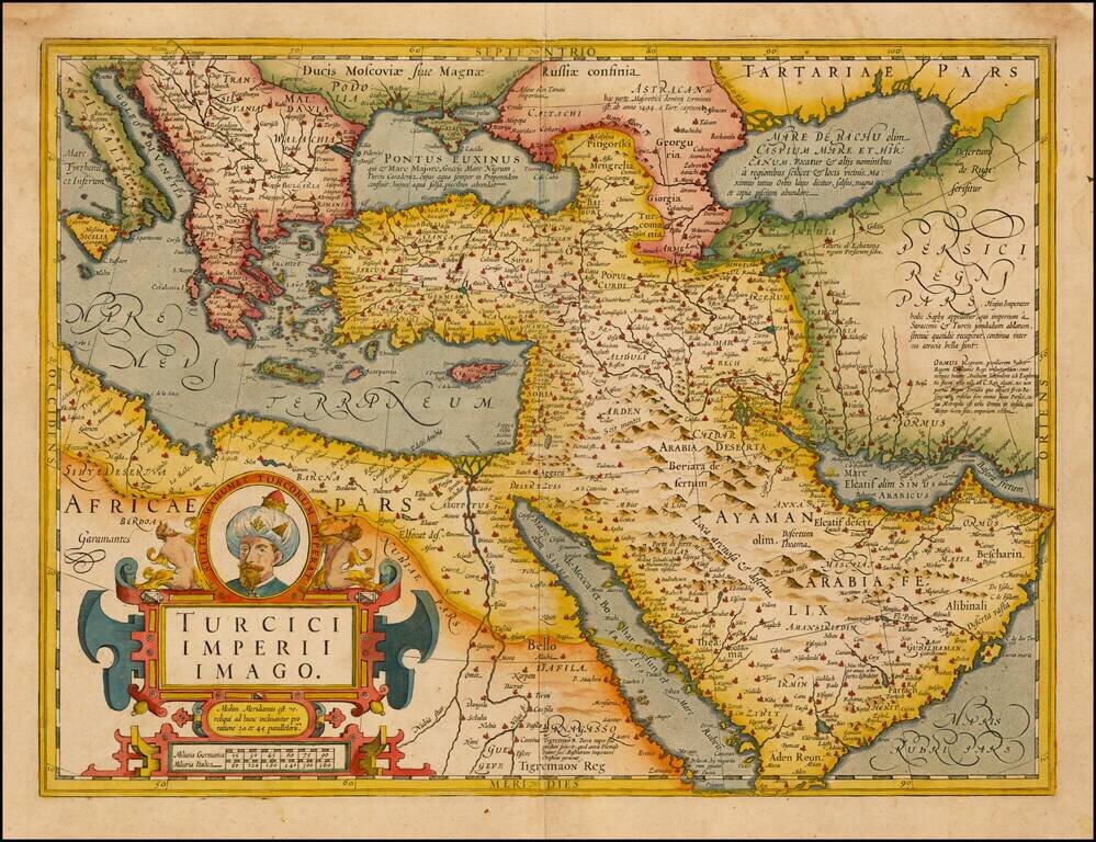
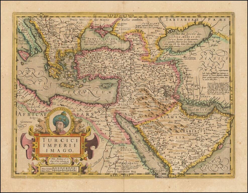
Decorative example of Blaeu's map of the Turkish Empire, based upon Blaeu's map of a similar title. Extends from Sicily and Italy in the west, to the Black and Caspian Seas in the north, and the Gulf of Aden, Red Sea and Saudi Arabia peninsula in the...
![Asia Minor [shows Cyprus]](/map/small/44708.jpg)
Striking full color example of Tallis' map of the region bounded by the Black Sea, Mediterranean, Aleppo and Diyar-Bekr, including a nice large Cyprus Vignettes of Olympus, Rhodes, a sailing vessel and Turkish costumes. Engraved for R. Montgomery...
Fine Map of the Ottoman Empire from the Mercator-Hondius Atlas Striking example of this map of the Ottoman Empire, showing their territories in the Balkans, Anatolia, the Levant, the Arabian Peninsula, and North Africa. It was published by Henricus...
Fine Map of the Ottoman Empire from the Mercator-Hondius Atlas Striking example of this map of the Ottoman Empire, showing their territories in the Balkans, Anatolia, the Levant, the Arabian Peninsula, and North Africa. It was published by Henricus...
![A New & Accurate Map of the Western parts of Barbary Containing Fez, Morocco, Algiers . . . [and] A New & Accurate Map of the Eastern parts of Barbary . . .[Shows Cyprus]](/map/small/67838.jpg)
Two engraved maps on one sheet showing the Mediterranean, with a focus on North Africa. The upper map extends from the Atlantic to "Tripoly," while the lower map extends from Tunisia to the Holy Land. In addition to the many states of North Africa,...
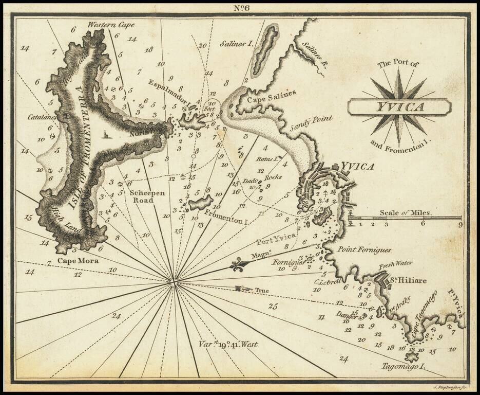
Very scarce miniature engraved chart of the town of Ibiza, on the Balearic Island of Ibiza. This is possibly the first English printed chart of the famous Spanish port city of Ibiza, now so well known for its world-class nightlife. The chart...