
![(Commodore Perry) [Names of Japanese Sumo Wrestlers.] [Nihon rikishi namae]](/map/small/55567.jpg)
Woodblock kawaraban showing Japanese sumo wrestlers carrying straw rice-bags (one bag weighs about 60 kg) to the American ship. At the second visit by Commodore Perry in 1854 the Edo government gave Perry 200 bags of rice. On this occasion, the Edo...
![[The United States in North America | Russian Empire in Europe] [Kita-Amerika-nai Gasshukoku | Yoroppa-nai teikoku Roshia]](/map/small/55548.jpg)
This kawaraban shows the portraits of two officers, an American and a Russian, with explanatory text printed around these figures it reflects the interest in these two powerful countries following their arrival in Japan in 1853. It seems likely that...
![[American Lady] [Amerika fujin] | [Chinese Man from Nanjing] [To Daishin Nankin-jin]](/map/small/55554.jpg)
Kawaraban Illustration of a 19-year-old American Woman. Interesting woodblock kawaraban illustrating a 19-year-old American woman named "Arikisanteru" [Alexandra], and a Chinese man from Nanjing kneeling at here feet suggesting he may be her...
![[On Europe: Dutch Man, English Man, Russian Man, North American Man, and French Man] [Yoroppa no bu: Oranda-jin, Igirisu-jin, Furansu-jin, Kita-Amerika-jin, Roshia-jin]](/map/small/55553.jpg)
Hand-colored woodblock kawaraban of five western men in military uniforms. Counter-clockwise from the top right they are: Dutch, French, American, English, and Russian. The accompanying text largely focuses on Dutch seaborne trade.
![(Commodore Perry) [Illustration of the Steam Locomotive.] [Jokisha no zu]](/map/small/55566.jpg)
The Miniature Steam Locomotive Commodore Perry Brought to Japan. Woodblock kawaraban print showing the miniature steam locomotive, which is one of the gifts to the Edo government Commodore Perry brought to Japan. The caption says "Gifts from Emperor...
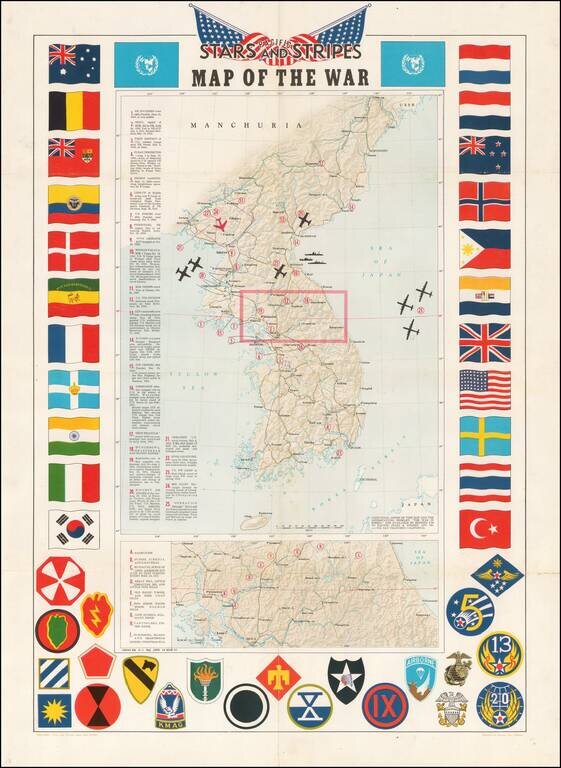
Decorative map of Korea, intended for distribution to soldiers stationed in Korea in the 1950s. Shaded relief with key military features locations marked and described. Includes a decorative border of flags of allies and insignia of military units.
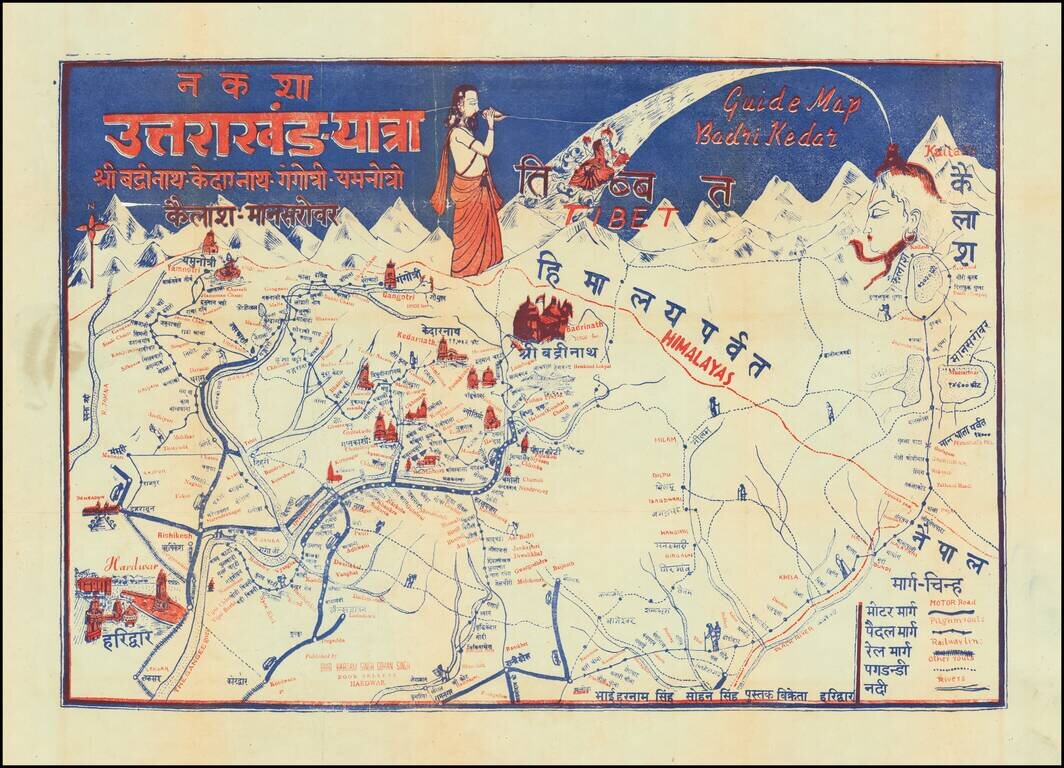
Pictorial Pilgrimage Guide Map for Uttarakhand, India Showing Important Holy Sites for Multiple Religions This interesting pictorial guide map shows pilgrimage routes for all the temples on the Chota Char Dam pilgrimage circuit, Badrinath, Kedarnath,...
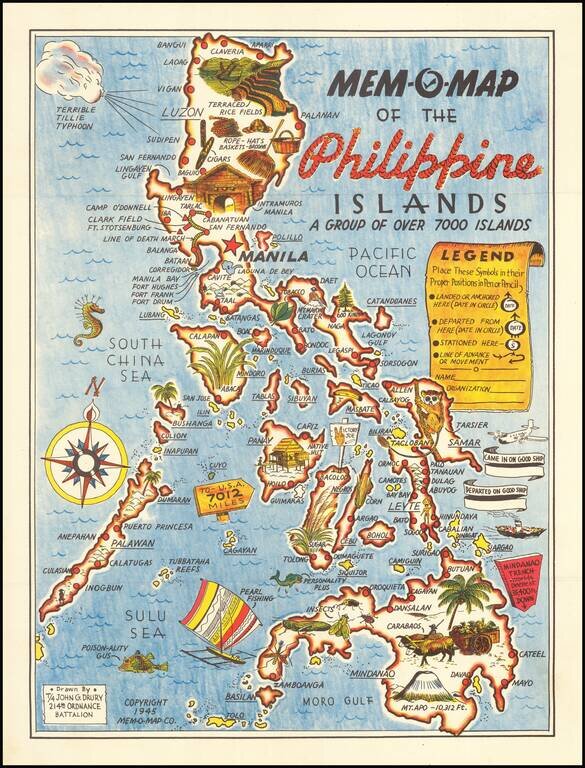
Lively pictorial map of the Philippines, drawn by John G. Drury of the 2145th Ordnance Battalion. This is one in a series of Mem-o-Maps published at the end of World War II. The maps were intended as souvenirs for the military. Military personnel...
![[Philippines] Pictorial Tour Map To The Scenic Wonders of the Mountain Province](/map/small/59513.jpg)
Rare promotional tour map of the Mountain Province, published by Capitol Publishing House. The map is centered on Mt. Data and the area around Bontoc and Baguio City. Points of interest include: Philippines Military Academy Baguio Cathedral...
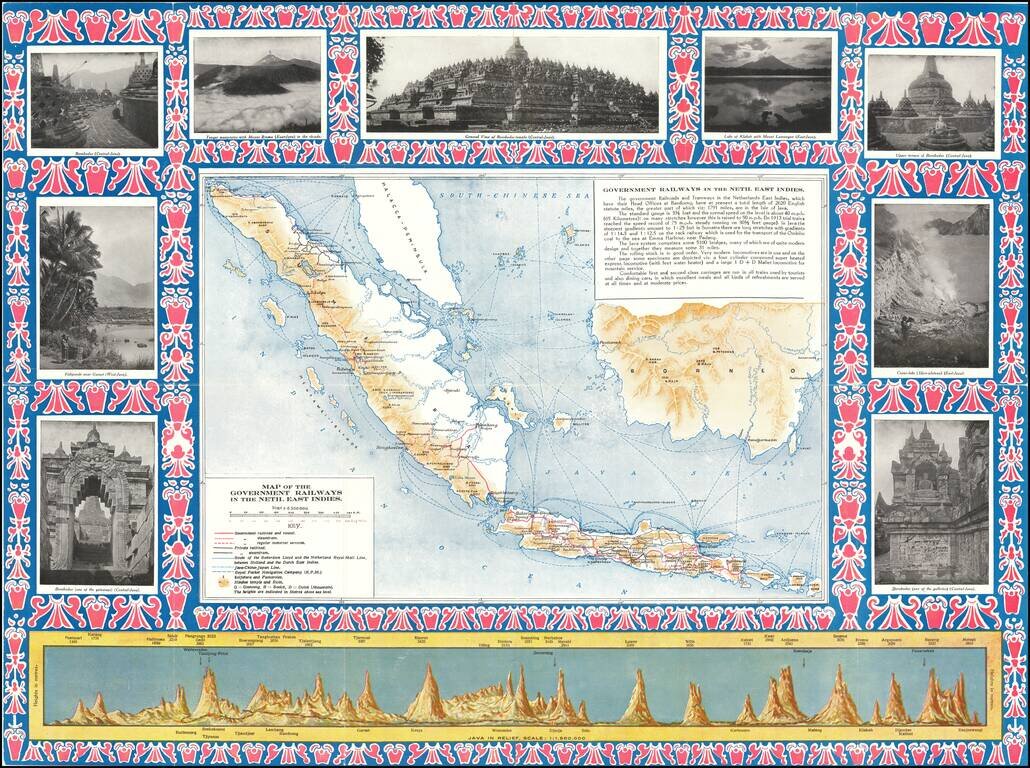
Detailed map of the Dutch East Indies, focusing on the Railroad Maps and other transportation routes in and around the islands. The map is ringed by photographs of points of interest in and around the islands, along with a profile view of the island...
![[Pictorial Map of the United Arab Republic] Kharitat Musawwarat al-Jumhuriya al-'Arabiya al-Muttahida / خريطة مصورة الجمهورية العربية المتحدة](/map/small/55146.jpg)
Fine Pictorial Map of the United Arab Republic Tourist map of the United Arab Republic, published by the Ministry of Tourism in Egypt in 1969. The map shows what is now Egypt during its short time as the United Arab Republic, as well as the boundaries...
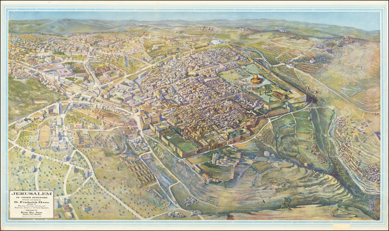
Scarce, large bird's eye view of Jerusalem published by G. Frederick Owen, in Kansas City, Missouri in 1947, the year before Israel was founded. The view looks north-northeast over Jerusalem, with the focus on the old walled city. Individual buildings...
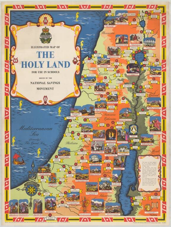
Fine pictorial / historical map of the Holy Land, issued by the National Savings Movement. We note that the map is signed by Mahoney, whose name appears on at least one other poster published by the National Savings Movement. A wide range of printed...
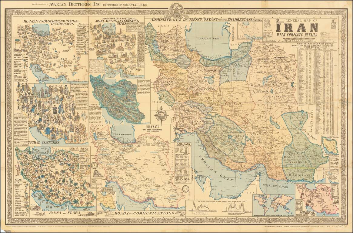
Interesting separately issued map of Iran, published in Tehran by A Sahab, one of the leading Iranian cartographic publishers. The main map is the primary depicts the cities and regions of Iran, with the surrounding maps showing This magnificent map...
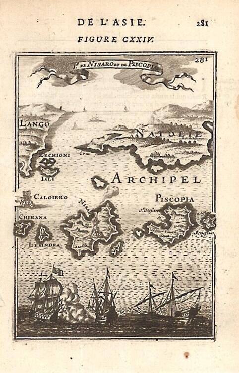
A detailed map showing Grecian Islands. From Mallet's monumental Description de l' Univers, first published in Paris in 1683, perhaps the greatest work of its kind in the 17th Century. Complete sets of this work are now fetching in excess of $15,000.00.
![[Africa - Anti-Colonialism]](/map/small/66878.jpg)
Striking image of Africa, with a quote from Amilcar Cabral. The map was likely printed shortly after Cabral's assassination in 1973. Always bear in mind that people are not fighting for ideas, for the things in anyone's head. They are fighting to...