Map size in jpg-format: 108.945MiB
Click to open in high resolution (open in new tab).
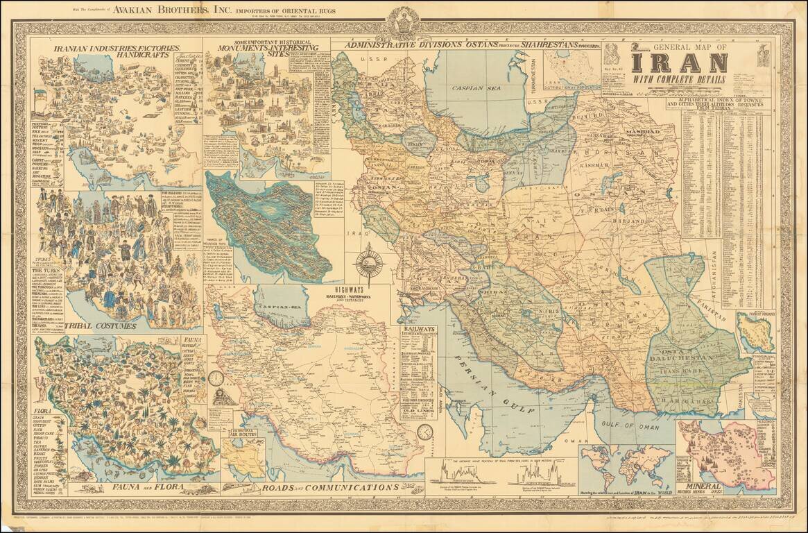
Interesting separately issued map of Iran, published in Tehran by A Sahab, one of the leading Iranian cartographic publishers.
The main map is the primary depicts the cities and regions of Iran, with the surrounding maps showing
This magnificent map of Iran with eleven in-set thematic maps and one chart was printed in Tehran in 1955. The in-set maps show:
Includes a table of city names and their distance from the capital as well as their elevations.
The map was made soon after the 1953 Iranian coup d'état, when the prime minister Mohammad Mosaddegh was overthrown by an Anglo-American covert operation that marked the first time the US had overthrown a foreign government during the Cold War.
The map is based on a drawing by Abbas Sahab, and it is an early version of his another map with the same title, published in the same year. The imprint names Sahab's private address, which later changed to his company's address.
This is the Seventh Edition. The map was published in both English and Persian.
The Sahab Geographic and Drafting Institute was founded in Tehran in 1935, the first private geographic and mapmaking enterprise in the Middle East.
Foounded by Abolghasem Sahab, the firm was later run by his son Abbas Sahab.
Abbas Sahab (1921-2000 is often called "Father of Iran’s Cartography". He was born in Fam, in Tafresh district in Iran. His father Ostad Abolghasem Sahab Tafreshi was a famous writer and author of about seventy titles on on historical, geographical, religious, cultural and artistic topics.
Addass Sahab devoted himself to cartography already during the time off his studies in Teheran. During his life he created more than 1,500 valuable works including maps, atlases, plates, scientific and medical illustrations, as well as geographical globes. Sahab was very active on the international level. He was an an active member of the International Cartographic Association Between 1968-1971 he issued maps of other countries such as Afghanistan, Pakistan, Iraq and Turkey.
In 1970 Sahab organised the First International Map Exhibition in the Tehran Teachers Training High School and in the next years he organised similar events in the other cities.In his last years he dedicated himself to his monumental work: The Great Atlas of 14 Centuries of Islamic Arts in 20 volumes, of which the first volume was published in 2000.
If you are a student, write to us in telegram: @antiquemaps and indicate what material you need and for what work you need a map in high detail. We are ready to provide material on special terms. For students only!

![Азіятская Турція, Персія, Аравія, и Часть Туркестана. [Asian Turkey, Persia, Arabia, and Part of Turkestan.]](/map/small/66732.jpg)