
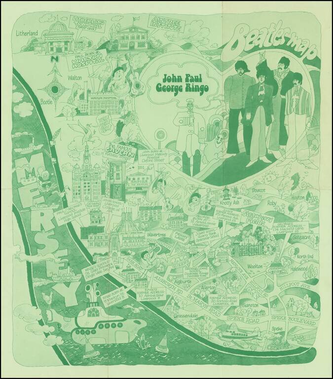
The Beatles Map of Liverpool was published in 1974 to commemorate the buildings and places where the Beatles started their career. As noted on the Liverpool Museums website: Featured here is one of the first Beatles maps of Liverpool that was ever...
![[Counterculture - Drug Culture] A Field Guide to American Wild Highs](/map/small/59955.jpg)
Map of the United States, surrounded by illustrations of mushrooms with psychotropic compounds, along with illustrations of Cannabis sativa (marijuana) and Lophophora williamsii (Peyote). The map includes numbers scattered around the US identifying...
![[French-Russian Soyuz T-6 Flight Poster] Советско-Французский Космический Полет 1982](/map/small/68336.jpg)
Attractive vintage Soviet poster celebrating the first joint French-Soviet space flight. The poster artist was R. Suryaninov ("Р. Сурьянинов"). Soyuz T-6 was a human spaceflight to Earth orbit to the Salyut 7 space station in 1982. Along...
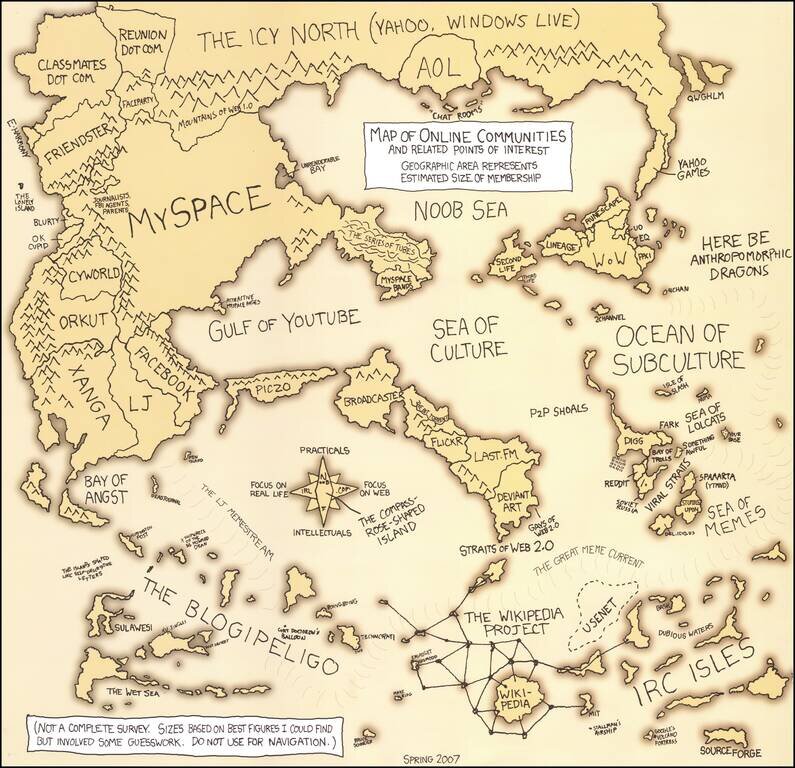
First Edition of Randall Munroe's Online Communities Map Fine example of Randall's first map of Online Communities, issued the year after Facebook became open to all users on September 26, 2006. As noted below the title "Geographic Area Represents...
![[World Map -- Thomas Cavendish Portrait] Thomas Candyssh nobilis Anglus aetatis suae XXXII.](/map/small/70349.jpg)
Extremely rare early double hemisphere world map and portrait of the explorer Thomas Cavendish, celebrating his circumnavigation of the World (1586-1588). The portrait is almost certainly from the pair of portraits of Cavendish and Sir Francis Drake,...
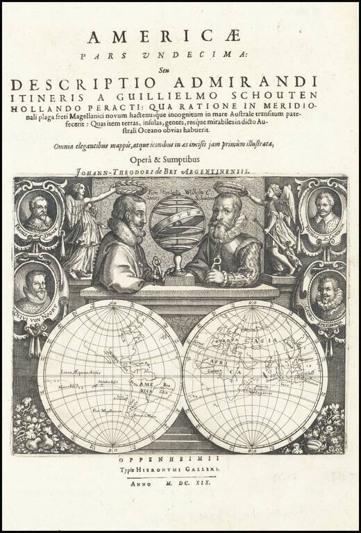
Double hemisphere map of the World, accompanied by portraits of a number of the most important 16th and early 17th Century explorers, which was included in Willem J. Schouten's America Pars Undecima . . . , first published by De Bry in 161. The map...
![[Title Page] Atlas Novus Terrarum Orbis Imperia Regna et Status exactis Tabulis Geographice demonstrans . . .](/map/small/54916.jpg)
Highly decorative title page, from Homann's Atlas Novus. Includes an allegorical image of Atlas holding the World aloft, along with images of Triton, Mercury and a number of other gods, overlooking a projection of the Globe showing Africa and Europe....
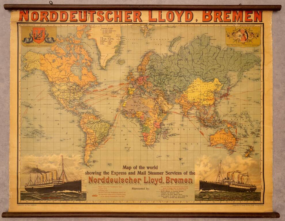
Fine promotional wall map of the world, promoting the Norddeutscher Lloyd line of Bremen. The map focuses on the routes of the Norddeutchser Lloyd Line, an important global steamship line in the 19th and 20th centuries. The routes of the line are...
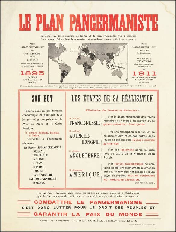
Fantastic anti-German polemic broadside map, issued in France during World War I, published by Adrien Maréchal. The map focuses on the so-called "Pan-Germanic Plan" of world domination. It rallies the French against the ever-expanding influence of...
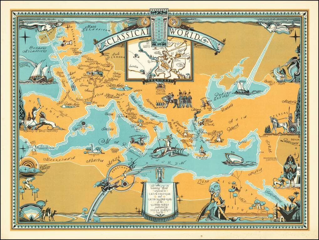
Rare pictorial map centered on the Mediterranean Sea, showing the world at the time of the Roman Empire, with place names in Latin. The map was produced for educational purposes to accompany a series of Latin textbooks published by Silver Burdett...
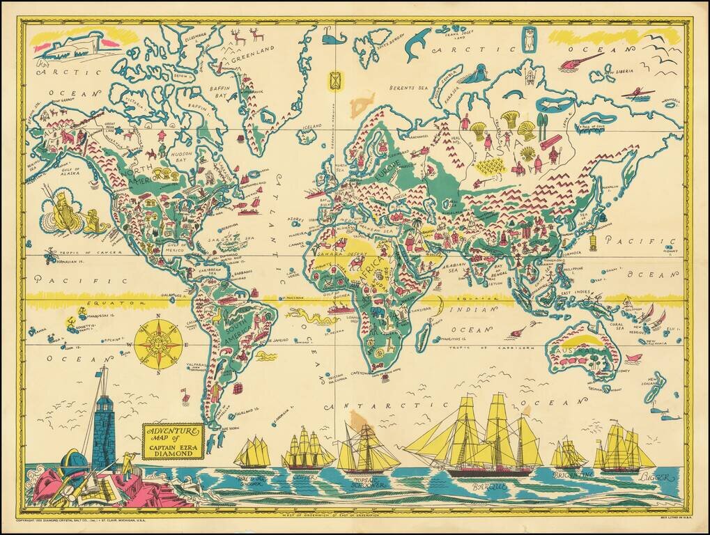
Rare Pictorial World Map, prepared as a promotional premium to promote the Captain Ezra Diamond Radio Show. Captain Ezra Diamond was the fictional spokesperson for the Diamond Salt Company began in the early 1930s. The company itself began some 50...
![[World] Air France -- Nova et Vetera Sur La Vieille Terre Des Chemins Nouveaux](/map/small/67467.jpg)
Rare Early Air France Map Decorative Air France Map Poster by Lucien Bouche. Presents a lively pictorial map of the World, with Air France routes extending to Buenos Aires and Santiago, New York, Cairo, Beyruth (Beirut), Calcutta, Saigon, and Hong...
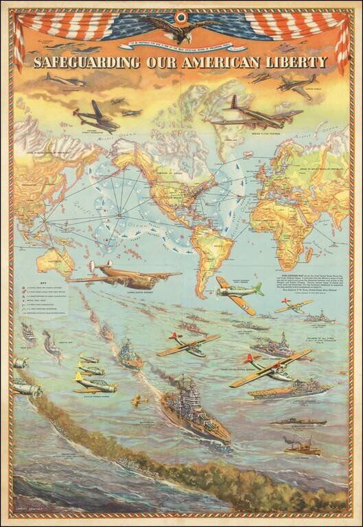
Provocative pictorial map depicting the United States Naval, Air and Coast Defense Bases. The map was created by Lambert Guenther to glorify the power and international reach of the United States military. The protective boundary of the air and sea...
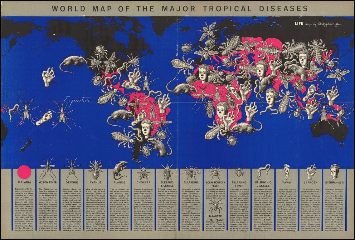
Tropical Disease Pictorial Map. A world map by a well-known artist of the time (Boris Artsybasheff) illustrating an article on tropical diseases. The use of ominous pictorial symbols for 15 diseases, combined with the size and location of the symbols...
![[World] Air France -- Reseau Aerien Postal](/map/small/65424.jpg)
Decorative Air France Map Poster by Atelier Percival, exhibiting the Air France Post Routes. Dated January 1848.
![[World] Air France](/map/small/67997.jpg)
Rare Reduce Sized Variant A decorative Air France poster map by Lucien Boucher, based on his 1948 map. The map presents a lively pictorial view of the World, with Air France routes extending to Buenos Aires, the Eastern United States, Tehran,...