Map size in jpg-format: 34.7722MiB
Click to open in high resolution (open in new tab).
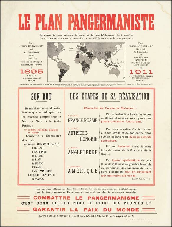
Fantastic anti-German polemic broadside map, issued in France during World War I, published by Adrien Maréchal.
The map focuses on the so-called "Pan-Germanic Plan" of world domination. It rallies the French against the ever-expanding influence of Germany in Europe and around the world.
The map image shows the areas desired for influence by Germany. The text blocks below the map elaborate Son But (Its Goals) and Les États de sa Réalisation (The State of Realization).
The goals of the Pan-Germanic Plan consist of: Réunir dans un seul domaine économique et politique tous les territoires compris entre la Mer du Nord et le Golfe Persique (y compris Hollande, Belgique et Suisse). Soumettre à l'hégémonie allemande. ["To bring together in a single economic and political domain all the territories lying between the North Sea and the Persian Gulf (including Holland, Belgium and Switzerland). Submit to German hegemony."] In this way, that map sagely predicts future developments of pan-European political and economic projects.
As of 1915, Germany had attempted to realize the plan through the following means (with translations):
The caption below the title reads:
En dehors de toute question de langue et de race, l'Allemagne vise a absorber les diverses regions dont la possession est consideree comme utile a sa puissance.
Translation: Apart from any question of language and race, Germany aims to absorb the various regions whose possession is considered useful to her power.
If you are a student, write to us in telegram: @antiquemaps and indicate what material you need and for what work you need a map in high detail. We are ready to provide material on special terms. For students only!


