Jan Janssonius (also known as Johann or Jan Jansson or Janszoon) (1588-1664) was a renowned geographer and publisher of the seventeenth century, when the Dutch dominated map publishing in Europe. Born in Arnhem, Jan was first exposed to the trade via his father, who was also a bookseller and publisher. In 1612, Jan married the daughter of Jodocus Hondius, who was also a prominent mapmaker and seller. Jonssonius’ first maps date from 1616.
In the 1630s, Janssonius worked with his brother-in-law, Henricus Hondius. Their most successful venture was to reissue the Mercator-Hondius atlas. Jodocus Hondius had acquired the plates to the Mercator atlas, first published in 1595, and added 36 additional maps. After Hondius died in 1612, Henricus took over publication; Janssonius joined the venture in 1633. Eventually, the atlas was renamed the Atlas Novus and then the Atlas Major, by which time it had expanded to eleven volumes. Janssonius is also well known for his volume of English county maps, published in 1646.
Janssonius died in Amsterdam in 1664. His son-in-law, Johannes van Waesbergen, took over his business. Eventually, many of Janssonius’ plates were sold to Gerard Valck and Pieter Schenk, who added their names and continued to reissue the maps.
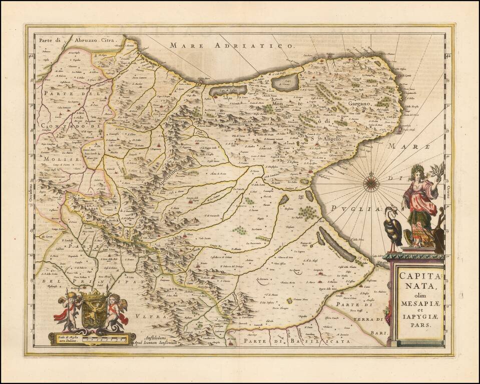
A nice example of Jan Janssonius's circa 1650 double-page engraved map of the Province of Foggia, Italy. Johannes Janssonius Johannes Janssonius (1588, Arnhem - buried July 11, 1664, Amsterdam) (born Jan Janszoon, often called Jan Jansson) was a...
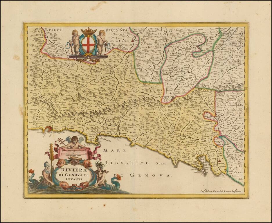
Decorative map of the Italian Riviera, including the Cinque Terre. Scarce Jan Jansson of the Italian Riviera, from Genoa to the Gulf of Spezia. Includes a decorative cartouche and coat of armes supported by Cherubs.
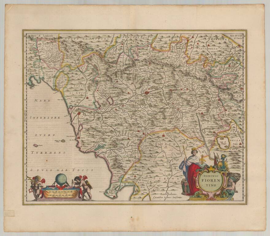
Gorgeous old color example of Jansson's map of Fiorentino, centered on Florence. Includes Siena, Perugia, Luca, and Pisa. Two large decorative cartouches. This example includes rich full hand coloring and was likely bound into a deluxe edition of...
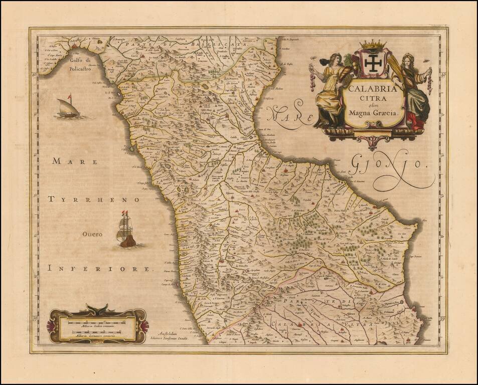
Nice old color example of Jansson's map of the north part Calabria. Includes sailing ships and decorative cartouche. Larger towns include Cosenza and Rossano.
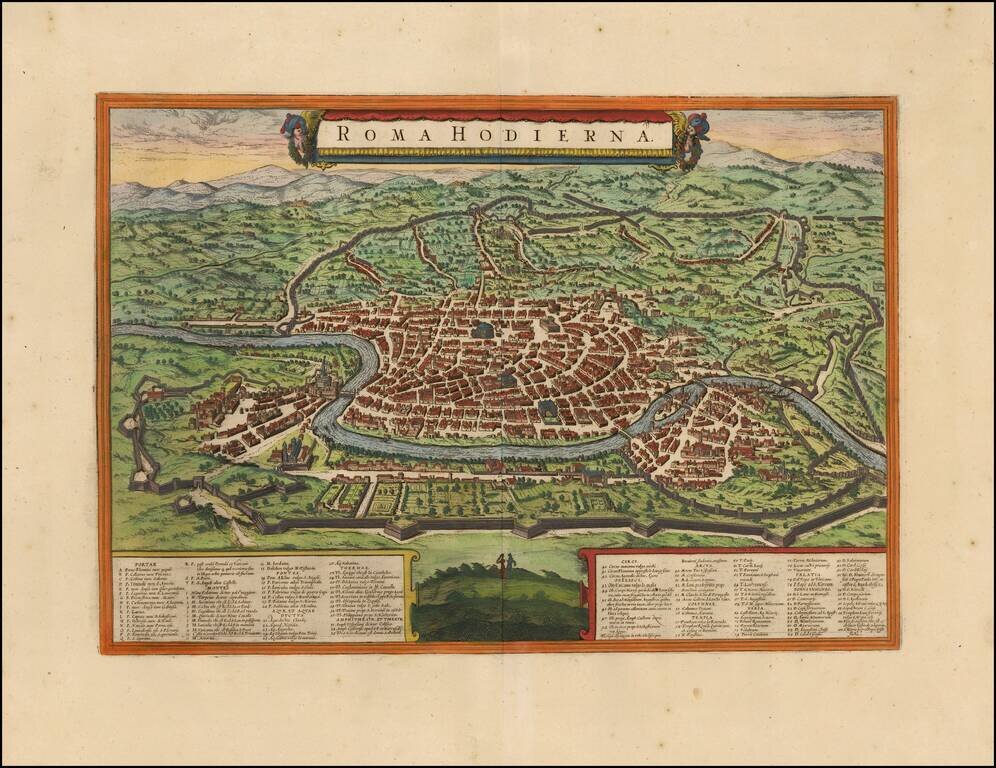
Fine example of Jansson's rare modern view of Rome, from his Theatrum Celebriorum Urbium Italiae, Aliarumque In Insulis Maris Mediterranei. Striking bird's-eye plan of Rome with decorative title cartouche, showing the city as it was c. 1550. Included...
![[Portugal] Pascaarte vande Zeecusten van Portugal tusschen de Barlenges en de C. de S. Vincente geleghen, vertoonende nae't leven de ware geleghentheijt vande vermaerde Riviere van Lisbona . . .](/map/small/40065.jpg)
Finely engraved sea chart of the Portuguese coastline, centered on Lisbon, which appeared in Johannes Janssonius's Het Licht der Zeevaert or Le Flambeau de la Navigation, first published in 1620. Jansson's sea atlas is a copy of Blaeu's Atlas of the...
![Natolia, quae olim Asia Minor [shows Cyprus]](/map/small/40634.jpg)
Jan Jansson's decorative engraved map of Asia Minor, showing Turkey, Cyprus, and the Islands in the Aegean. This attractive map shows all of Turkey, Cyprus and the Aegean Islands to a relatively high degree of accuracy. At the time the entire region...

The Turkish Empire in the 17th Century A very nice example of Jansson's rare map of the Turkish Empire, based upon Blaeu's map of a similar title. The map extends from Sicily and Italy in the West to the Black and Caspian Seas in the North and the...
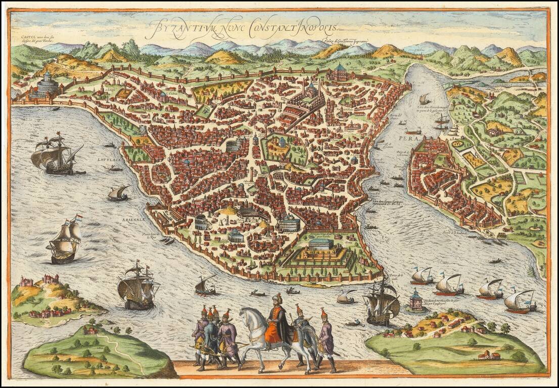
Rare map / birdseye view of Istanbul, from Jansson's monumental town book. Jansson's view is one of the finest and most sought-after views of Istanbul. Viewed from the village of Scutari, the City is shown with all its fortifications, the original...
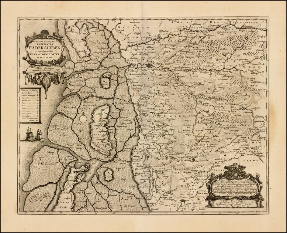
Detailed map of western Denmark, extending from Fano Island in the north, to Sylt Island in the south, showing what was then the western part of the Prefecture of Haderslev. The map includes an elaborate dedication cartouche.
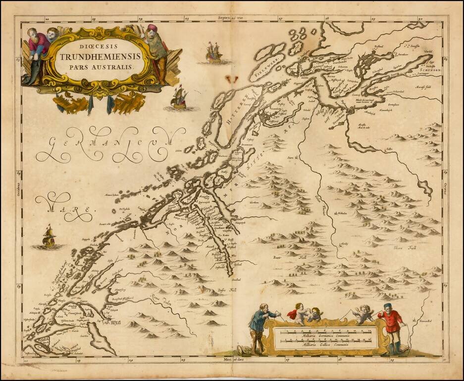
Scarce map of the Southern part of the Diocese of Trondheim in Norway, first published by Jan Jansson in Amsterdam for his Atlas Major.
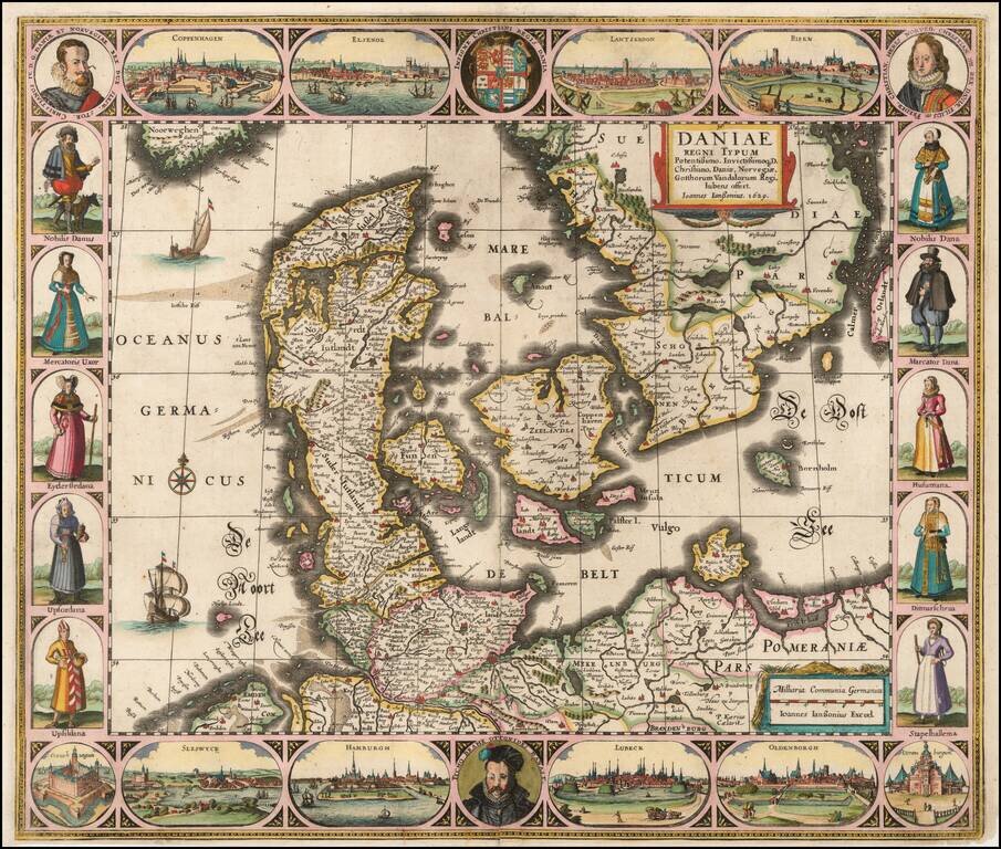
Striking example of the Jansson carte-a-figures map of Denmark, published in Amsterdam. The map includes a portrait of Tycho Brahe bottom center and city views of: Coppenhagen Elsenor Lanskroon Ripen Veraniburgum Oldenborgh Lubeck Hamburg...
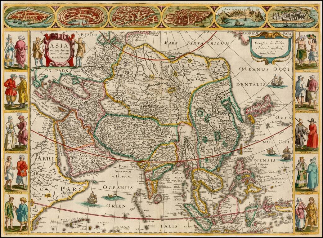
A very fine 'Carte à Figures' map of Asia, by Jan Jansson, after his brother-in-law Jodocus Hondius. This highly attractive map embraces all of Asia. The Middle East is very well formed, although the Caspian Sea has the egg-like form it maintained...
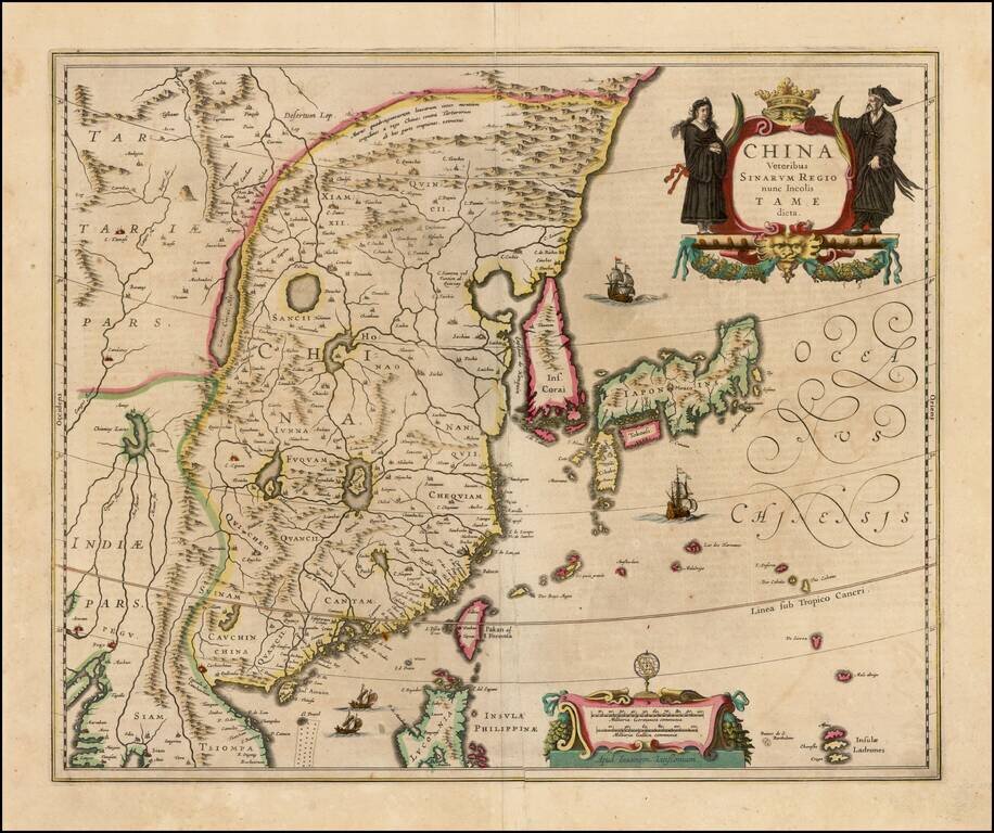
Decorative map of China, Japan and Korea and includes the north portion of the Philippines from Jansson's Novus Atlas. The map depicts the eastern part of China (bounded in the west by the Great Wall), Korea as an island and the three main islands of...
![Iaponiae Nova Descriptio [Korea as an island]](/map/small/56910.jpg)
Jansson’s Early Map of Japan, Showing Korea as an Island Fine example of one of the earliest European atlas maps of Japan, which also shows Korea as an island. The Jansson Japan is a delicate and skilled reworking of the Mercator-Hondius atlas map...
![[Sri Lanka] Insula Zeilan olim Taprobana nunc incolis Tenarisim](/map/small/59295.jpg)
Decorative map of Sri Lanka, published in the later editions of Jansson's atlas. A striking image, with a decorative title cartouche and scale of miles held aloft by mer-cherubs.