Map size in jpg-format: 8.20826MiB
Click to open in high resolution (open in new tab).
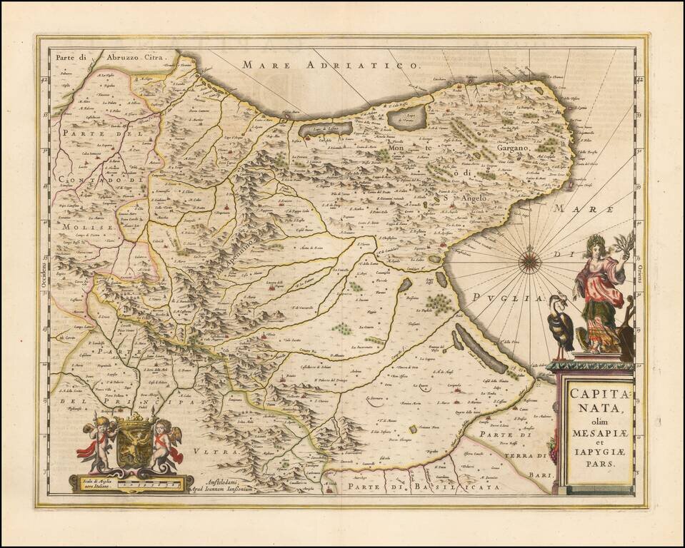
A nice example of Jan Janssonius's circa 1650 double-page engraved map of the Province of Foggia, Italy.
Johannes Janssonius
Johannes Janssonius (1588, Arnhem - buried July 11, 1664, Amsterdam) (born Jan Janszoon, often called Jan Jansson) was a Dutch cartographer and publisher who lived and worked in Amsterdam in the 17th century.
In 1612, Jansson married Elisabeth de Hondt, the daughter of Jodocus Hondius, and in doing so joined one of the great mapmaking families of the time. In the 1630s he formed a partnership with Henricus Hondius. Together they published the Mercator-Hondius-Janssonius Atlas, which, under Johannes's guidance, was steadily enlarged.
Jansson's career was characterized by ongoing competition with the Blaeu family, and at times he was accused of copying the latter.
Jan Janssonius (also known as Johann or Jan Jansson or Janszoon) (1588-1664) was a renowned geographer and publisher of the seventeenth century, when the Dutch dominated map publishing in Europe. Born in Arnhem, Jan was first exposed to the trade via his father, who was also a bookseller and publisher. In 1612, Jan married the daughter of Jodocus Hondius, who was also a prominent mapmaker and seller. Jonssonius’ first maps date from 1616.
In the 1630s, Janssonius worked with his brother-in-law, Henricus Hondius. Their most successful venture was to reissue the Mercator-Hondius atlas. Jodocus Hondius had acquired the plates to the Mercator atlas, first published in 1595, and added 36 additional maps. After Hondius died in 1612, Henricus took over publication; Janssonius joined the venture in 1633. Eventually, the atlas was renamed the Atlas Novus and then the Atlas Major, by which time it had expanded to eleven volumes. Janssonius is also well known for his volume of English county maps, published in 1646.
Janssonius died in Amsterdam in 1664. His son-in-law, Johannes van Waesbergen, took over his business. Eventually, many of Janssonius’ plates were sold to Gerard Valck and Pieter Schenk, who added their names and continued to reissue the maps.
If you are a student, write to us in telegram: @antiquemaps and indicate what material you need and for what work you need a map in high detail. We are ready to provide material on special terms. For students only!


