![[San Francisco Fire Satirical Cartoon] Uncle Sam -- Smoke Up Frisco! You're Bound To Be Bigger and Better Than Ever Before!](/map/small/70102.jpg)
Uncle Sam Reflecting Upon Aid To San Francisco Following The 1906 Earthquake Provocative image of Uncle Sam smoking a cigar and reflecting upon the $20,000,000 in aid contributed to San Francisco, following the 1906 San Francisco Earthquake. The...
![[San Francisco Fire Satirical Cartoon] Judge -- Never Mind Sister; They're All Going To Help](/map/small/70101.jpg)
Financial Aid To San Francisco Following The 1906 Earthquake Fascinating Image Showing a Statue of Liberty-like image of San Francisco in the wake of the 1906 earthquake, with a caricature of a wave of financial aid coming to help the city, , drawn...
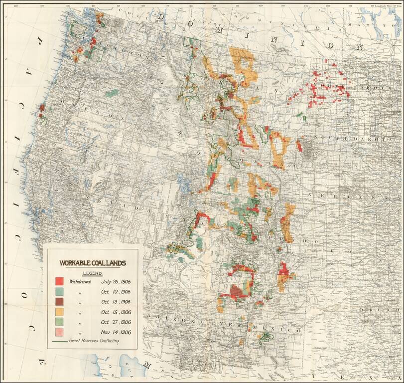
Rare separately published map of the Western United States focusing on coal production. While the map at first appears to be 1 sheet of a larger map, our research suggests that this map is in fact a re-use of the western sheet of a US Government...
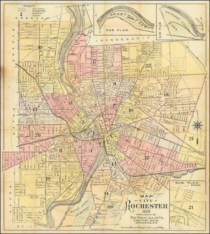
Scarce early map of Rochester, New York, published and lithographed in Rochester. The map is colored by wards and captures the breadth of the city at a highpoint in the City's history. After the Civil War, Rochester grow from a city of 48,000 to a...
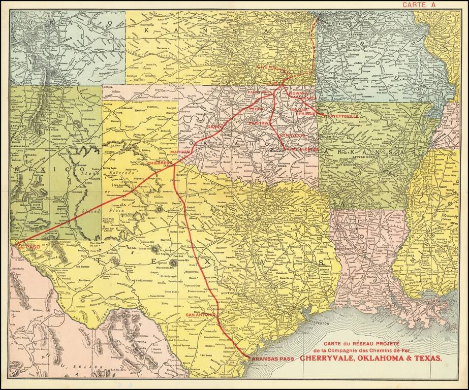
Promoting Railroads To French Investors Fine example of this rare promotional map centered on Texas, Oklahoma and Kansas, published to attract French investors in the issuance of bonds to construct the Cherryvale, Oklahoma & Texas Railway. This...
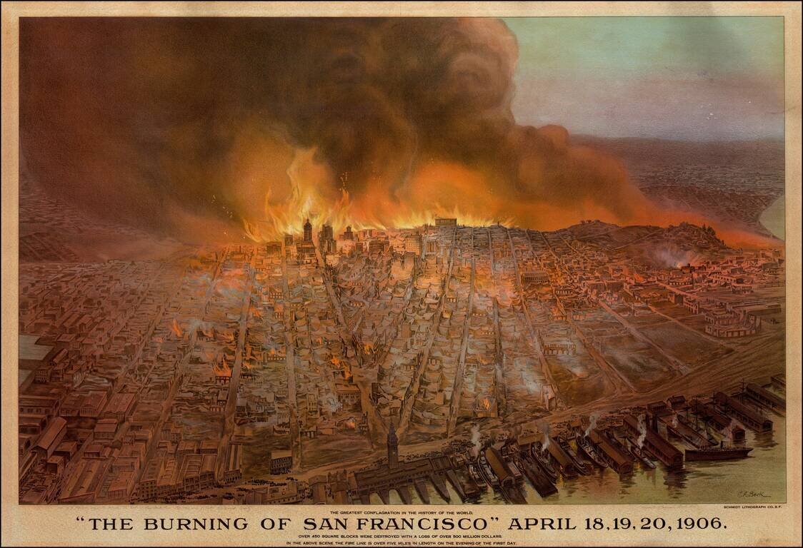
Striking Cityscape of San Francisco on Fire Detailed and dramatic view of San Francisco on fire after an earthquake in 1906. On the wharf, the lithographic print shows steam ships ready to depart the docks. A crowd is gathered nearby, presumably to...
![Map of City and County of San Francisco. H.A. Candrian, Copyright 1906 -- [Promotional Map for California Art Glass Works] [Map of Oakland, Alameda & Berkeley on verso]](/map/small/69224.jpg)
Striking map of San Francisco, published in 1906. The map includes advertising for California Art Glass Works and Hanson Co. Printing. Includes a fine large map of Oakland, Berkeley and Alameda on the verso.
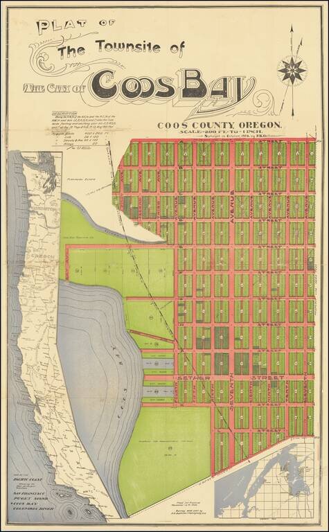
An Oregon Paper City Interesting four-stone color-lithographed real estate promotion map for the city of Coos Bay, Oregon, a proposed settlement on the east side of the bay. In this map, the City of Coos Bay is imagined as a counterpoint to the...
![(Maui). Harbours and Anchorages in the Hawaiian or Sandwich Islands. [Maalaea Bay and Kahului Harbor and Approaches]](/map/small/69674.jpg)
Maui Harbors Rare British Admiralty Chart, showing Kahului Harbor and Maalaea Bay, on the island of Maui Maalaea Bay includes a number of early placenames, including Kihei. Kahului Harbor shows the breakwaters, town plan, etc., extending north to...
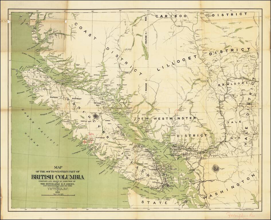
With Annotations By An Early Logging Concern? Important early Map of Southwestern British Columbia, published by the Department of Lands and Works. The map which depicts the relative locations of various Land Districts and Divisions in south-west...
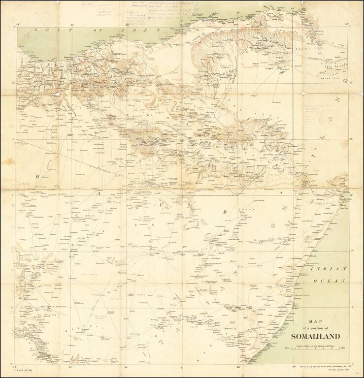
Rare Ordinance Survey Map of Northern Somalia and Eastern Ethiopia, published by the British Ordnance Survey in 1906. The map provides an overview of roads, topography and coastal details, along with the Anglo-Ethiopian Treaty boundary of July 28,...
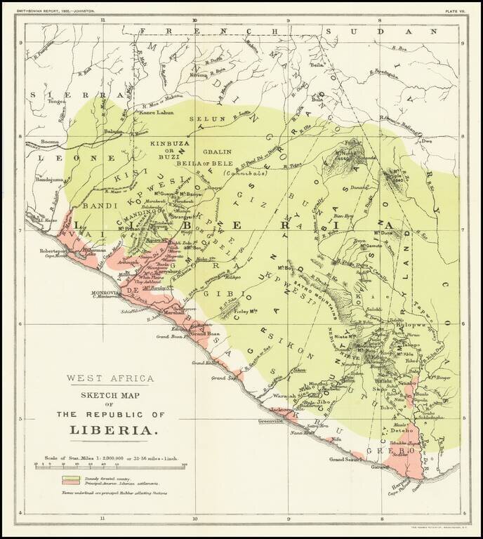
Mapping The Freed American Slave Efforts -- Republic of Liberia Scarce map of the Republic of Liberia, which illustrated an article by Sir Harry Johnston on Liberia, which was read at the Royal Geographical Society on March 27, 1905 and appeared in...
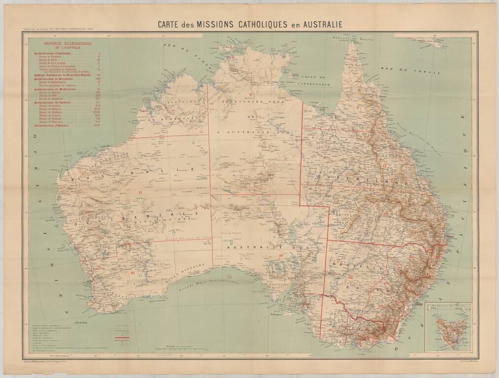
Rare map showing the Catholic Missions in Australia, published as a supplement to the Journal Les Missions Catholiques in Paris. The map provides a marvelously detailed look at the Catholic Missions throughout the Austrlian Continent.