Map size in jpg-format: 58.4491MiB
Click to open in high resolution (open in new tab).

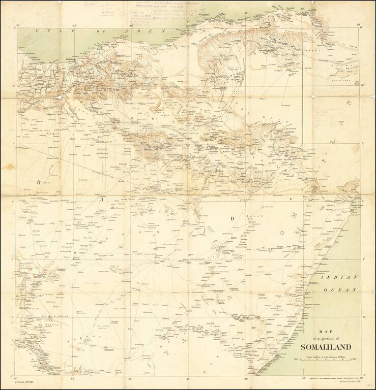
Rare Ordinance Survey Map of Northern Somalia and Eastern Ethiopia, published by the British Ordnance Survey in 1906.
The map provides an overview of roads, topography and coastal details, along with the Anglo-Ethiopian Treaty boundary of July 28, 1897.
The map is extensively annotated by an early user. The note at the top right corresponds with a phrase in the Official History of the Operations in Somaliland 1901-04, published by the War Office. As such, we assume that his map was used by a British soldier.
A number of lines drawn on the map intersect in the general area of Wadamago. It is possible that the map is associated with Brigadier-General Henry Alexander Walker, British Army officer who served with the Royal Fusiliers regiment, and later with the King's African Rifles in the First World War. In January 1909 - 1910, Walker was the first to arrive with 300 Askari of 1 KAR from Nyasaland. The battalion marched up to Wadamago where it maintained escort duties and fatigues for a year before returning to Nyasaland. In February 1909, Battalion Headquarters and 450 Askari of 3 KAR, under Lieutenant Colonel J.D. McKay (Middlesex Regiment), arrived from Kenya and also performed security duties in the Wadamago region for a year.
British Somaliland
In 1888, after signing successive treaties with the then ruling Somali Sultans from the Isaaq, Issa, Gadabursi, and Warsangali clans, the British established a protectorate in the region referred to as British Somaliland. The British garrisoned the protectorate from Aden and administered it from their British India colony until 1898. British Somaliland was then administered by the Foreign Office until 1905 and afterwards by the Colonial Office.
The present map was published shortly after the conclusion of the so called Dervish uprising.
If you are a student, write to us in telegram: @antiquemaps and indicate what material you need and for what work you need a map in high detail. We are ready to provide material on special terms. For students only!


