Map size in jpg-format: 41.2174MiB
Click to open in high resolution (open in new tab).
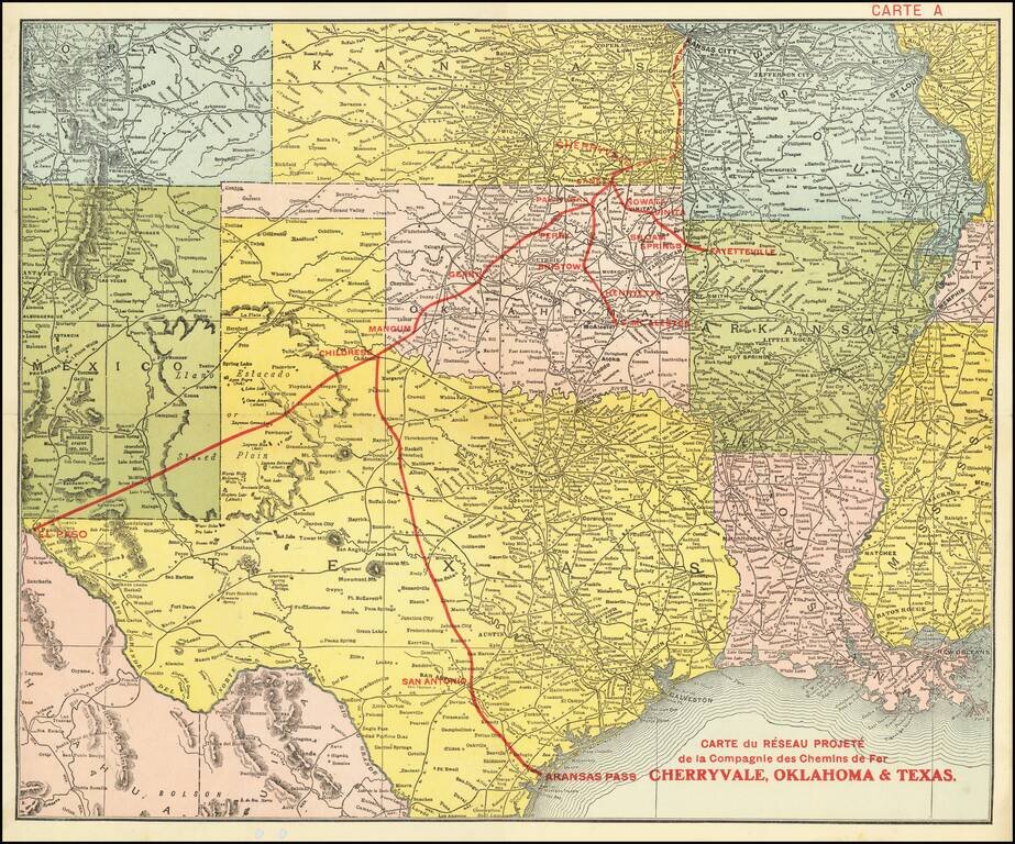
Promoting Railroads To French Investors
Fine example of this rare promotional map centered on Texas, Oklahoma and Kansas, published to attract French investors in the issuance of bonds to construct the Cherryvale, Oklahoma & Texas Railway.
This is an example of the promotion of an investment in an American company which was almost certainly promoted in Europe as well, as the verso of the bonds issued by the company include text on the verso is both French and German.
The addition of the "Carte A" (Map A) in the top, suggests it was part of a larger promotional effort.
The map title translates as: Map of the proposed Cherryvale, Oklahoma & Texas Railway Company network. The Railroad Gazette, Volume 41, No. 6, p 38 (1906), included the following note:
CHERRYVALE. OKLAHOMA & TEXAS.—Local reports state that W. R. Stubbs, of Lawrence [Kansas], and Senator Sam Porter, of Caney [Kansas], have completed the financing for this proposed road, which is to be 320 miles long. The proposed route is from Cherryvale, Kan., on the A., T. & S. F. and the St. L. & San Francisco, southwest to Geary, Okla., on the Rock Island. The work will cost about $4,000,000. A charter which was granted in Oklahoma describes a line 900 miles long. It is the intention of the promoters eventually to extend the line to El Paso.
By the fall of 1910, work had stopped on the line and the company borrowed money from the Carnegie Trust Company of New York, granting Carnegie Trust a $20 Million mortgage on its assets.
The map was almost certainly published in the United States, using an existing larger map of the United States and then adding overprinting in red for the promotional details.
Rarity
The map is extremely rare. OCLC locates an example of the map in the SMU Library (dated 1902?),
A different version of the map in English also seems to have been published. The Bibliotheque National de France notes the following: Map showing projected lines of the Cherryvale, Oklahoma and Texas Railroad and branches. 60 Miles to 1 Inch, with a publication address of 16 place Vendome, Paris, which it dates to 1910. https://gallica.bnf.fr/ark:/12148/btv1b8445368b
It is worth noting that the underlying uncolored map used by the BNF is identical to this map, but the red overprinting is somewhat different. This may simply be a difference in the registration of the stencil, but on closer inspection, we believe that it is an entirely new stencil, based upon a comparison of the letters, an may even be slightly different type font.
If you are a student, write to us in telegram: @antiquemaps and indicate what material you need and for what work you need a map in high detail. We are ready to provide material on special terms. For students only!


