Map size in jpg-format: 9.67883MiB
Click to open in high resolution (open in new tab).

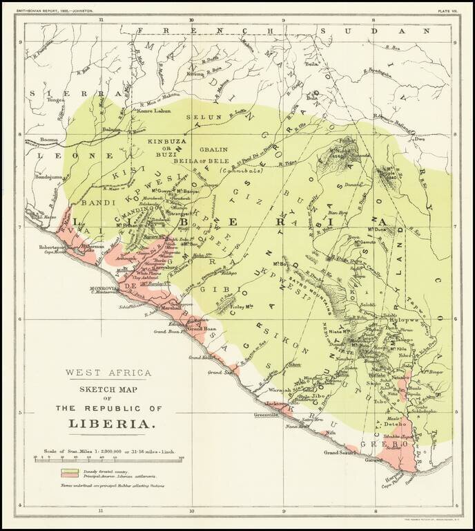
Mapping The Freed American Slave Efforts -- Republic of Liberia
Scarce map of the Republic of Liberia, which illustrated an article by Sir Harry Johnston on Liberia, which was read at the Royal Geographical Society on March 27, 1905 and appeared in the Annual Report Of The Board Of Regents Of The Smithsonian Institution 1905.
The map offers a meticulous accounting of the settlements and villages created by the formation of Liberia through the resettlement of American Freed Slaves among the local populations during the period from the early 1820s to the middle of the Century.
The color coding for the map references:
Liberia
The larger American Colonization Society was founded in 1816. It supported the settlement of thousands of free African Americans to their colony based in Monrovia in West Africa, along the coast.
In 1822 the American Colonization Society began sending black volunteers to the Pepper Coast, the closest point of Africa and therefore the least expensive to reach, to establish a colony for freed blacks.
The ACS, supported by prominent American politicians such as Abraham Lincoln, Henry Clay, and James Monroe, believed repatriation of free African Americans was preferable to widespread emancipation of slaves. Similar state-based organizations established colonies in Mississippi-in-Africa, Kentucky in Africa, and the Republic of Maryland, which Liberia later annexed. However, Lincoln in 1862 described Liberia as only "in a certain sense...a success", and proposed instead that free blacks be assisted to emigrate to Chiriquí, today part of Panama.
If you are a student, write to us in telegram: @antiquemaps and indicate what material you need and for what work you need a map in high detail. We are ready to provide material on special terms. For students only!
![[Wall Map] West-Indische Paskaert waer in de graden der breedde over weder zyden vande middelyn wassende so vergrooten dat die geproportioneert syn tegen hunne nevenstaende graden de lengde.](/map/small/60169.jpg)
![[The First Maps in a la poupée Printed Color] Cartes en Couleur des Lieux Sujets aux tremblements de Terre Dans toutes les parties du Monde Selon le Sisteme de l’impulsion Solaire](/map/small/52293op.jpg)
