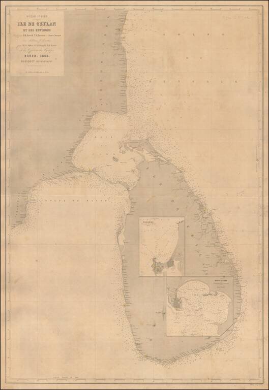
A Rare Large Chart of Sri Lanka Scarce large format sea chart of Sri Lanka and the adjacent coast of India with inset maps of the harbors at Colombo and Galle. Detail is confined to the coastlines, and includes soundings, navigational hazards and...
![[Myanmar] Gulf of Bengal Sheet VII Bassein, Rangoon, Martaban Compiled from various Surveys by Captns. D. Ross and J. Crawford, Bombay Marin, Lieut. Roe, R.N. Lieuts. W. Fell and C.Y. Ward, I.N. and Captn. Beckford 1859.](/map/small/67658.jpg)
Finely detailed British Sea Chart, showing the region drained by the Irawaddy River in Myanmar.
![[Lake Tanganyika, Lake Victoria and Northwest Tanzania]](/map/small/63611.jpg)
Fine early map of Northeast Tanzania, published as part of a Petermann & Hassenstein's map of Inner Africa. The map features a number of roads and the routes of 19th Century African explorers, including: Burton & Speke - 1857-58 Speke -...
![[Uganda - South Sudan ]](/map/small/63642.jpg)
Fine early map of Northern Uganda,Lake Albert and the southern part of South Sudan, published as part of a Petermann & Hassenstein's map of Inner Africa. The map features a number of roads and the routes of 19th Century African explorers,...