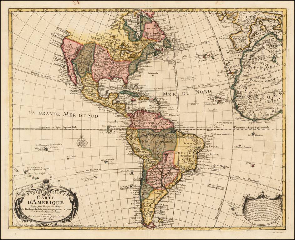
A Rare Map of America By the Royal Belgian Geographer Fine old color example of Eugene Henri Fricx's rare and finely engraved map of America, published by Guillaume De L'Isle in Paris. De L'Isle's map of America was compiled from the best available...
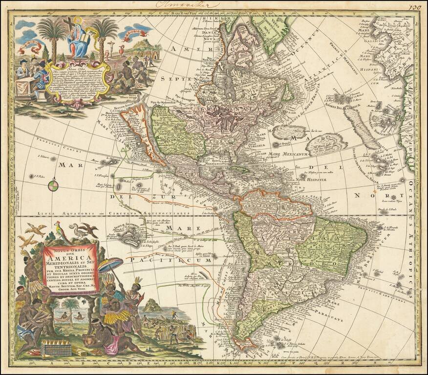
Striking, Richly Engraved Map of the Americas Fine, decorative and detailed map of the Americas, with California as an island and two richly illustrated cartouches. The present map depicts the Americas and parts of France, Spain, Portugal, and...

Decorative regional map of eastern Germany. Major cities include Leipzig and Halle.
![[Allegorical Map of Love!] Representation Symbolique et ingenieuse projettée en Siege et en Bombardement, comme il faut empecher prudemment les attaques de L'amour.](/map/small/47259.jpg)
Famous hand-colored engraved allegorical map, representing the battle for the heart. This is a wonderful and scarce allegorical map representing the trials and tribulations of romantic entanglement, published by one of Germany's greatest mapmakers of...
![[Allegorical Map of Love!] Representation Symbolique et ingenieuse projettée en Siege et en Bombardement, comme il faut empecher prudemment les attaques de L'amour.](/map/small/64005.jpg)
Famous hand-colored engraved allegorical map, representing the battle for the heart. This is a wonderful and scarce allegorical map representing the trials and tribulations of romantic entanglement, published by one of Germany's greatest mapmakers of...
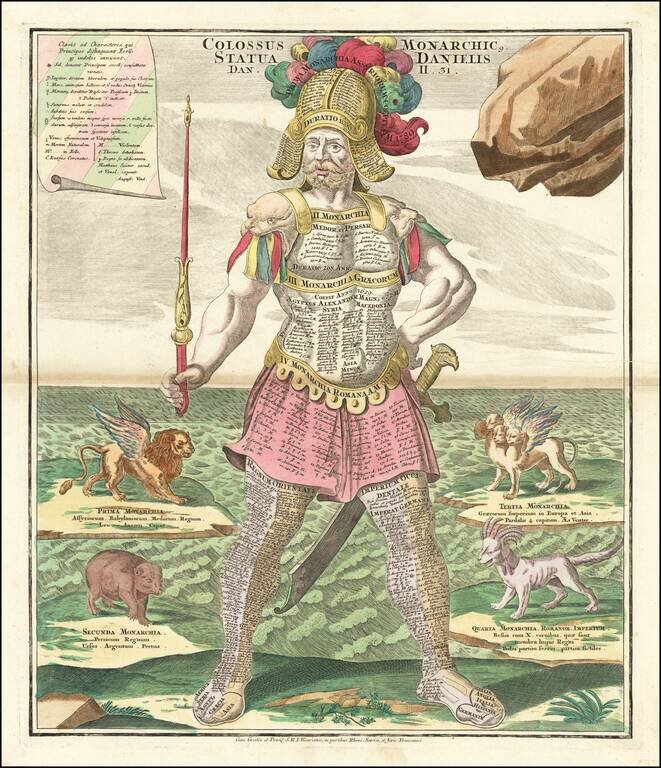
Striking example of Seutter's figure of Colossus, with sword and scepter, representing Daniel's interpretation of King Nebuchadnezzar's dream (Dan. 2:39-40). History's great empires are engraved on the breastplate; Oriental empires on the left leg,...

This is an unusual thematic chart shows the traveling distances from various European cities in a style that is still used today. Several similar charts were made during this time, but this one gives a very large number of combinations, some nearly...
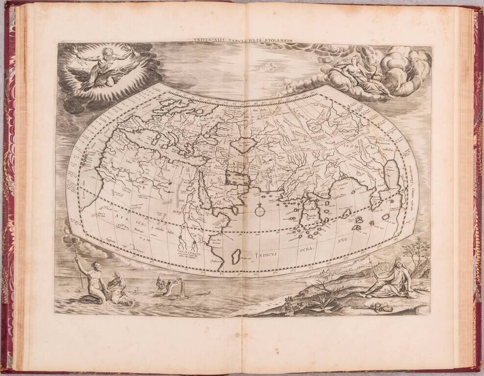
Nice example of the last edition of the Mercator/Ptolemy atlas, with engraved frontispiece, and 28 double-page engraved maps. "All maps, except the world map, have a graticule and the matching letters in the border added. For one map (Europe 7)...
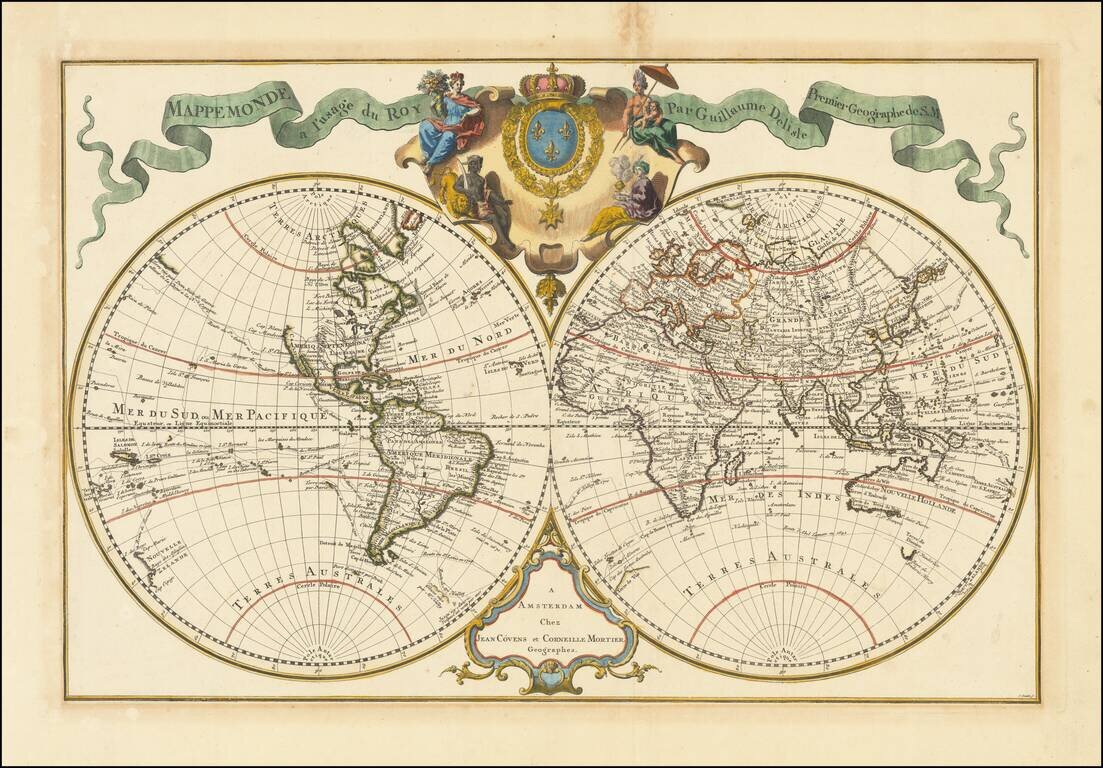
Nice Example of Covens & Mortimer's De L'Isle World Map Showcasing European Exploration This is an example of a first edition of Covens' and Mortiers' decorative double hemisphere map of the world by De L'Isle. It shows the extent of oceanic...

Fine Map of the Northern Hemisphere Rare Henri de Leth edition of Guillaume De L'Isle's map of the Northern Hemisphere, originally published by De L'Isle in 1714. The map shows the entire Northern Hemisphere. The projection has the opposite effect of...
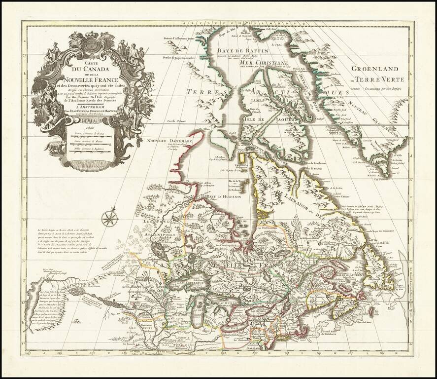
Fine example of Covens & Mortier's edition of De L'Isle's seminal map of Canada, the Great Lakes and Upper Midwest, and one of the most important and influential maps of Canada published in the 18th Century. De L'Isle's map is of seminal...
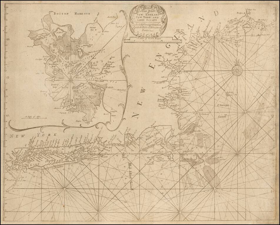
A "Pirated Dublin" Sea Chart of New England and Long Island A rare chart of the New England coast adapted from the work of Cyprian Southack and published in a Dublin edition of the English Pilot. The Fourth Book. The chart depicts the northeast...
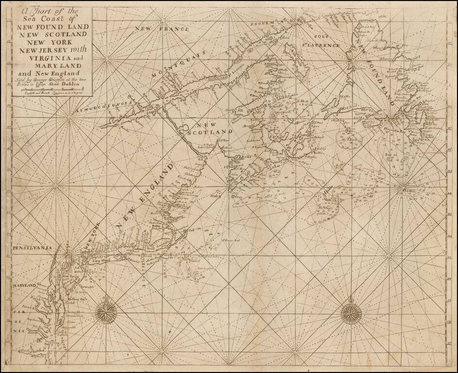
A "Pirated Dublin" Sea Chart of the Northeast Coastlin of North America. A rare chart of the coastline adapted from the work of Cyprian Southack and Mount & Page and published in a Dublin edition of the English Pilot. The Fourth Book. The chart...
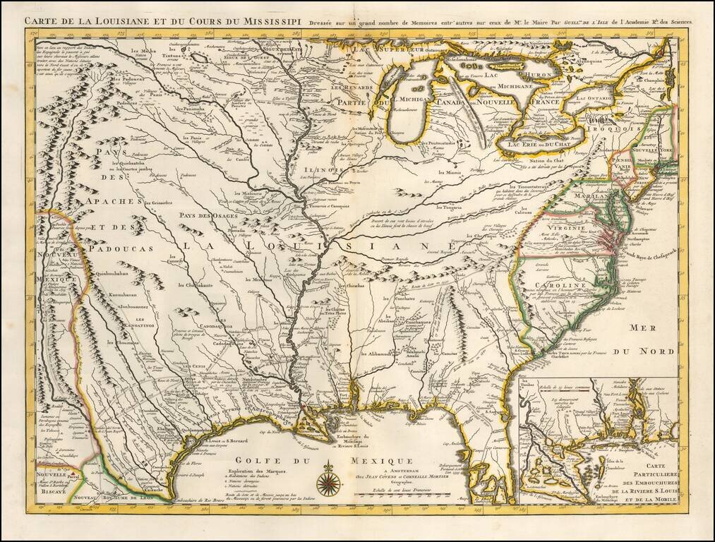
One of the Earliest Appearances of New Orleans Nice old color example of Covens & Mortier's fine edition of Guillaume De L'Isle's seminal map, the most significant map of the Mississippi Valley and Great Lakes published in the early part of the...
![Plan De Guadalaira Place Forte appartenant aux Espagnols dans la Nouvelle Espagne F. A. Wattenwyl fecit. 1730 [Manuscript Plan of Guadalajara, Mexico]](/map/small/32660.jpg)
A Proposal for Vauban Style Fortifications In Guadalajara, Mexico Fine early plan of the town and proposed fortifications of Guadalajara, Mexico, drawn by Watenwyll, who appears to be a trained engineer of Swiss or Austrian descent who was familiar...
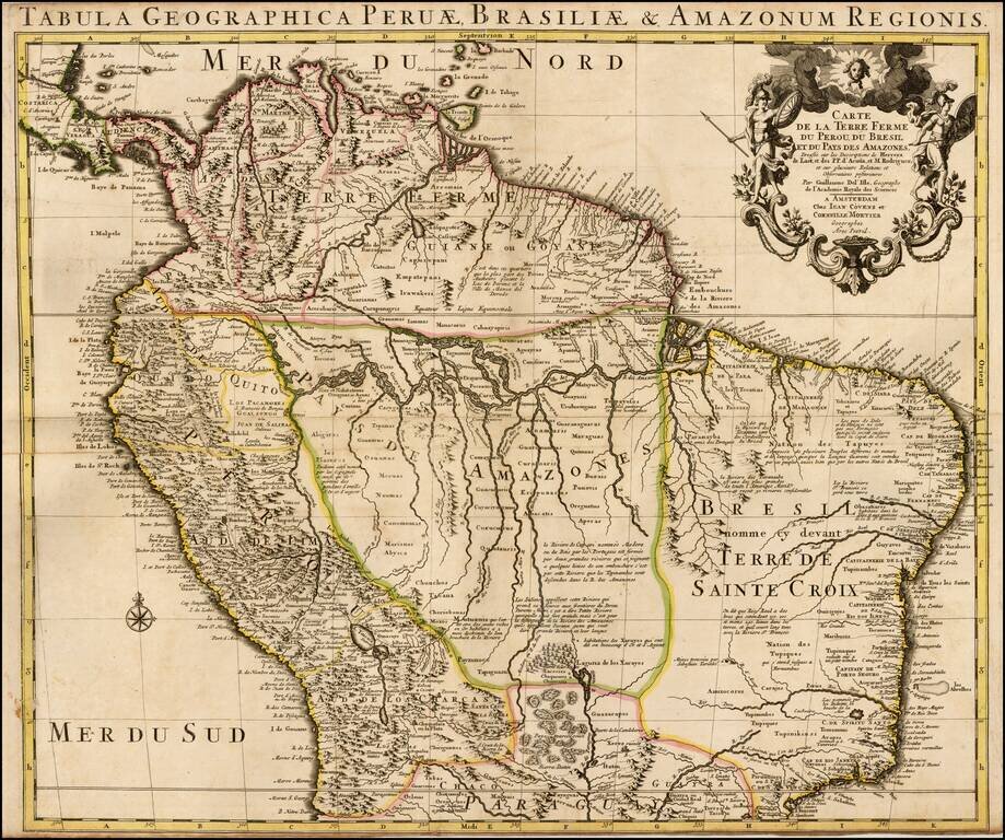
Nice old color example of Coven's & Mortier's edition of De L'Isle's maps of the northern part of South America. The map sjows Colombia, Venezuela, Peru, Ecuador, Brazil, Guiana and parts of Bolivia, Chile, Paraguay and Argentina. De L'Isle was...