logo

1682. Italy Distinguished according to the extent of all The States, Kingdoms, Republiks, Dukedoms, Principalites &c. That does at present divide it. Sold by William Berry . . . 16

  • Italy Distinguished according to the extent of all The States, Kingdoms, Republiks, Dukedoms, Principalites &c. That does at present divide it.  Sold by William Berry . . . 16

Italy Distinguished according to the extent of all The States, Kingdoms, Republiks, Dukedoms, Principalites &c. That does at present divide it. Sold by William Berry . . . 16 information:

Year of creation: 
Resolution size (pixels): 
 21390x13706 px
Disk Size: 
 87.4774MiB
Number of pages: 
 1
Place: 
 London
Author: 

Print information. Print size (Width x height in inches):
Printing at 72 dpi 
  297.08 х 190.36
Printing at 150 dpi 
 142.6 х 91.37
Printing at 300 dpi 
 71.3 х 45.69

An example of detailing the file of this map of in a printable high-resolution:

Click to open in high resolution (open in new tab).
Attention! this is just the central piece (central area 960x960 px) of the map file!
This is an example, so that you can see and study the level of detail of a given map. The entire Map will be fully available after payment!

Italy Distinguished according to the extent of all The States, Kingdoms, Republiks, Dukedoms, Principalites &c. That does at present divide it.  Sold by William Berry . . . 16

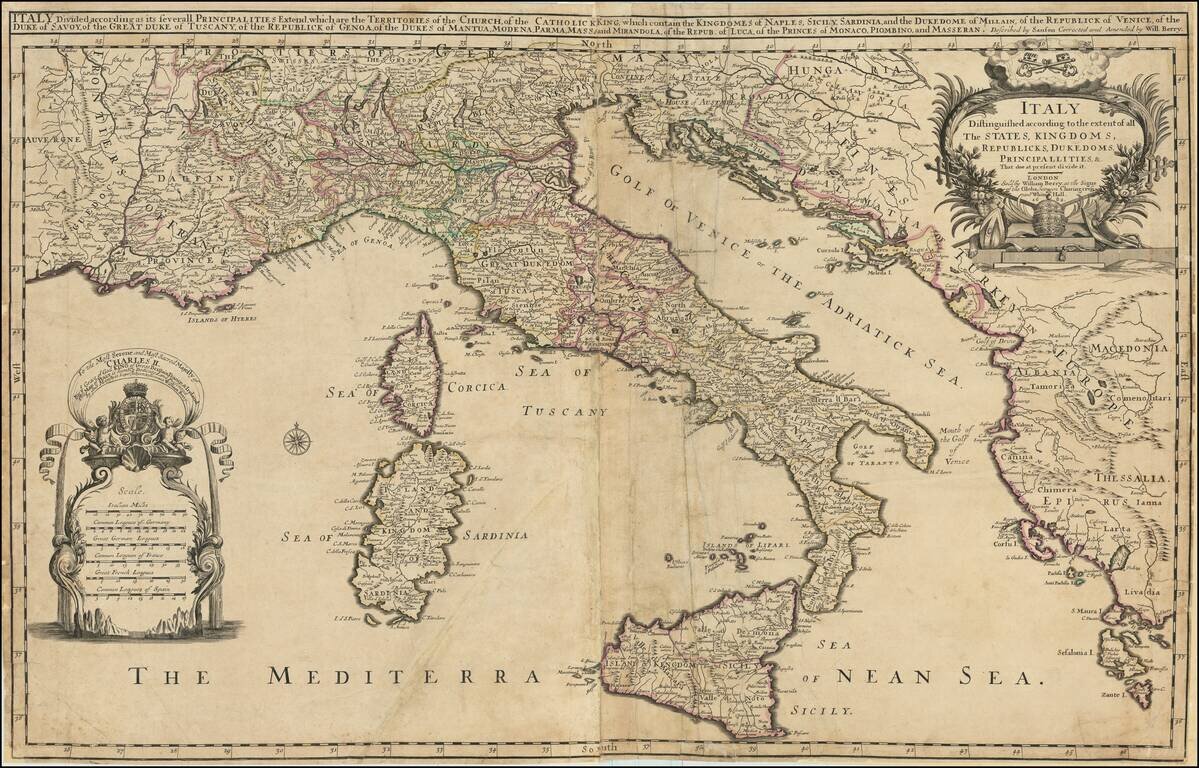
Rare example of William Berry's 2 sheet map of Italy, Corsica, Sardinia, Sicily, and adjoining regions.

The map includes a large dedication cartouche to Charles II, King of England. Dated 1682, the map was issued shortly after Charles dissolved the English Parliament in 1681 and the Popish Plot and Exclusion Crisis, when it was revealed that Charles's brother and heir presumptive, James, Duke of York, was a Catholic. The crisis saw the birth of the pro-exclusion Whig and anti-exclusion Tory parties. Charles sided with the Tories, and, following the discovery of the Rye House Plot to murder Charles and James in 1683, some Whig leaders were executed or forced into exile.

William Berry's maps were typically issued separately and are extremely rare on the market.


Special conditions for students!

If you are a student, write to us in telegram: @antiquemaps and indicate what material you need and for what work you need a map in high detail. We are ready to provide material on special terms. For students only!

Item information:

Year of creation:
Size:
21390x13706 px
Disk:
87.4774MiB
Number of pages:
1
Place:
London
Author:
William Berry.
$21.99

Related item