logo

1805. Carte de la Capitainerie Generale De Caracas Comprenant les Provinces de Venezuela, Maracaibo, Varinas, Cumana, la Guiane, et Isle de la Margeurite, Pour servir au Voyage a la partie oriental de la Terre Ferme dans l'Amerique Meridionale fait en 1801, 180

  • Carte de la Capitainerie Generale De Caracas Comprenant les Provinces de Venezuela, Maracaibo, Varinas, Cumana, la Guiane, et Isle de la Margeurite, Pour servir au Voyage a la partie oriental de la Terre Ferme dans l'Amerique Meridionale fait en 1801, 180

Carte de la Capitainerie Generale De Caracas Comprenant les Provinces de Venezuela, Maracaibo, Varinas, Cumana, la Guiane, et Isle de la Margeurite, Pour servir au Voyage a la partie oriental de la Terre Ferme dans l'Amerique Meridionale fait en 1801, 180 information:

Year of creation: 
Resolution size (pixels): 
 15438x10112 px
Disk Size: 
 49.8302MiB
Number of pages: 
 1
Place: 
 New York

Print information. Print size (Width x height in inches):
Printing at 72 dpi 
  214.42 х 140.44
Printing at 150 dpi 
 102.92 х 67.41
Printing at 300 dpi 
 51.46 х 33.71

An example of detailing the file of this map of in a printable high-resolution:

Click to open in high resolution (open in new tab).
Attention! this is just the central piece (central area 960x960 px) of the map file!
This is an example, so that you can see and study the level of detail of a given map. The entire Map will be fully available after payment!

Carte de la Capitainerie Generale De Caracas Comprenant les Provinces de Venezuela, Maracaibo, Varinas, Cumana, la Guiane, et Isle de la Margeurite, Pour servir au Voyage a la partie oriental de la Terre Ferme dans l'Amerique Meridionale fait en 1801, 180

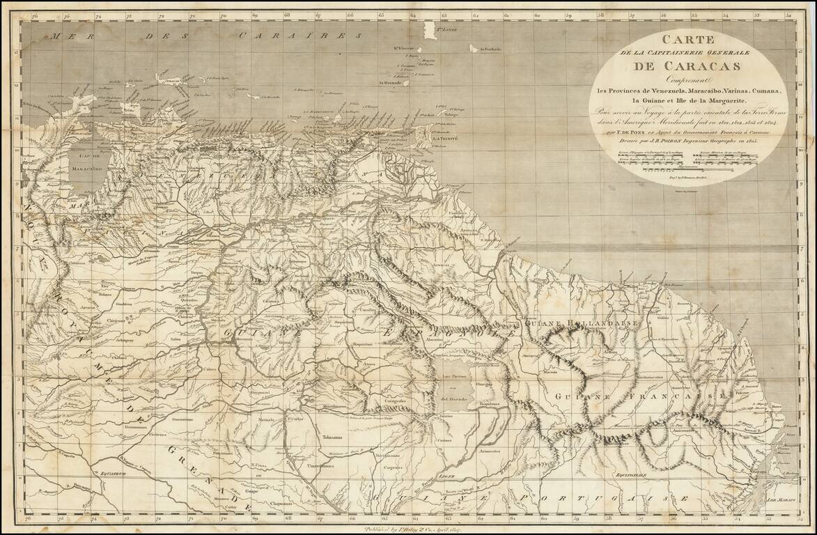
A Rare Early New York Imprint -- Includes A Reference To El Dorado

Scarce and highly detailed map of the Captaincy of Caracas, published by I Riley & Co, April 1807.

The map covers the area from Maracaibo and Curacao to the mouth of the Amazon River, illustrating the travels of Francois Raymond Joseph de Pons.

The map was part of an important account of Venezuela, giving a description of the country and people, and also accounts of the growth and production of cocoa, indigo, sugar, coffee, and tobacco.

Born in Haiti, François Raymond Joseph de Pons studied in Paris, qualified as a lawyer and was elected to the Académie des Sciences. In 1801 de Pons went to Caracas in Venezuela, where for four years before the revolution he acted as an agent of the French government. He then proceeded to England, where he spent some time preparing his narrative for publication, before returning top France, where he became an important consultant on South American affairs.


Special conditions for students!

If you are a student, write to us in telegram: @antiquemaps and indicate what material you need and for what work you need a map in high detail. We are ready to provide material on special terms. For students only!

Item information:

Year of creation:
Size:
15438x10112 px
Disk:
49.8302MiB
Number of pages:
1
Place:
New York
Author:
Benjamin Tanner. Peter Maverick.
$14.99

Related item