
Rare old maps of the United States.

The First National Atlas of the United States. The Exceptionally Rare 1783 Edition of Jeffery’s American Atlas. Thomas Jefferys' American Atlas was one of the four great atlases of the Colonies available during the Revolution - along with Faden's...
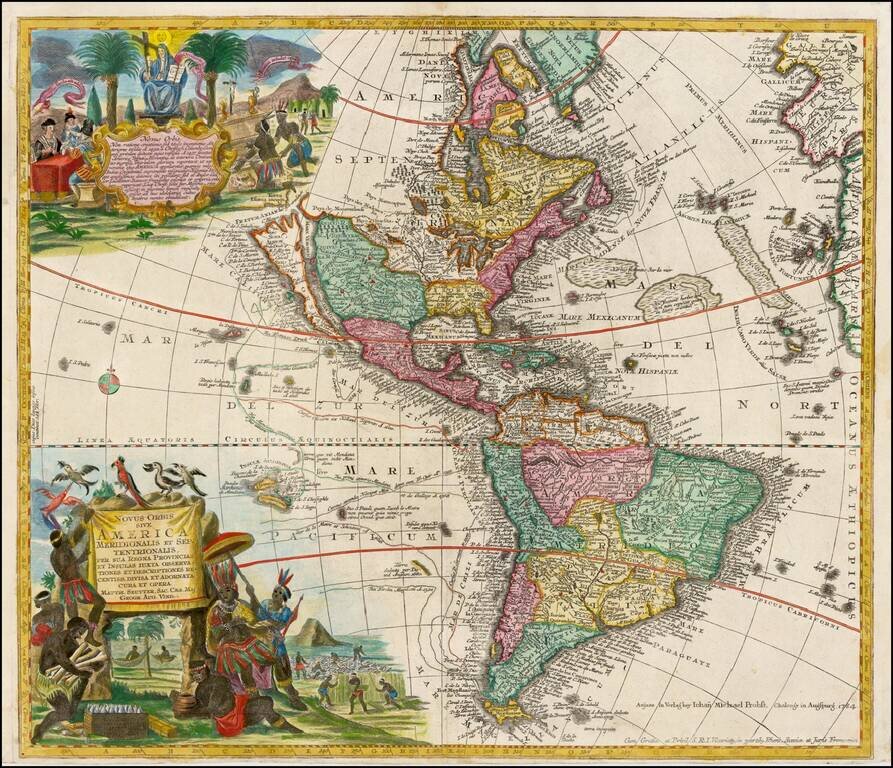
Striking, Richly Engraved Map of the Americas—One of the Last to Feature California as an Island Fine, detailed map of the Americas, with California as an island and two richly illustrated cartouches. This is one of the last maps to be printed with...
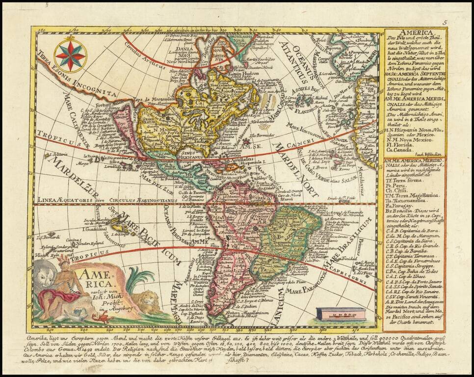
Rare map of America, showing California as an Island. California is shown as an Island, with the extended westward land mass to Asia and the Mississippi River extending to the Straits of Anian. Odd Great Lakes Projection and other interesting...
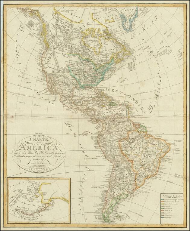
Fine-Lewis & Clark era map of America, reflecting the geo-political boundaries immediately after the Louisiana Purchase. Mississippi Territory is shown prior to the creation of Alabama. Massive Indiana Territory pre-dates the creation of Michigan...

A detailed map of America, by John Arrowsmith. The map shows the lands from "Russian America" to an unclaimed Patagonia, at a time when many parts of the continent were truly wild. Major cities, rivers, islands, lakes, and much more are all shown....
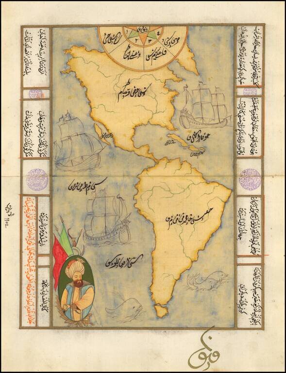
Decorative manuscript map of America, showing California as an island, with decorative embellishments. Maps of this type are typically hand drawn for tourists in Istanbul, using old paper which frequently includes earlier manuscript writing in...

"A scientific and artistic document of the first order" -- One of the most important sea charts of the 17th century. Exceptionally rare Johannes Loots issue of Guillaume Blaeu's landmark sea chart of the Atlantic Ocean, America and Africa, printed on...
![Carte des parties Nord et Est de L'Asie qui comprend Les Costes De Russie Asiatique Le Kamschatka, Le Iesso et Les Isles Japon…[insets of Alaska, West, AZ and Conibas]](/map/small/70673rd.jpg)
Marvelous depiction of the Northeast Passage, from Norway and Spitsberg Island to the Straits of Anian and Cape Schalaginskoy north of Kamschatka, covering the NE Coast of Asia to south of Japan and Korea. The primary focus of the map is Asiatic...
![Pascaart vertoonende de zeecusten van Chili, Peru, Hispania Nova, Nova Granada, en California…. [Early New Zealand Inset]](/map/small/65168.jpg)
Fine Golden Age Dutch Chart with the Island of California and an Early Mapping of New Zealand Scarce early sea chart by Doncker, showing the West Coast of the Pacific Ocean, which extends from the island of California to Chile, with noteworthy insets...
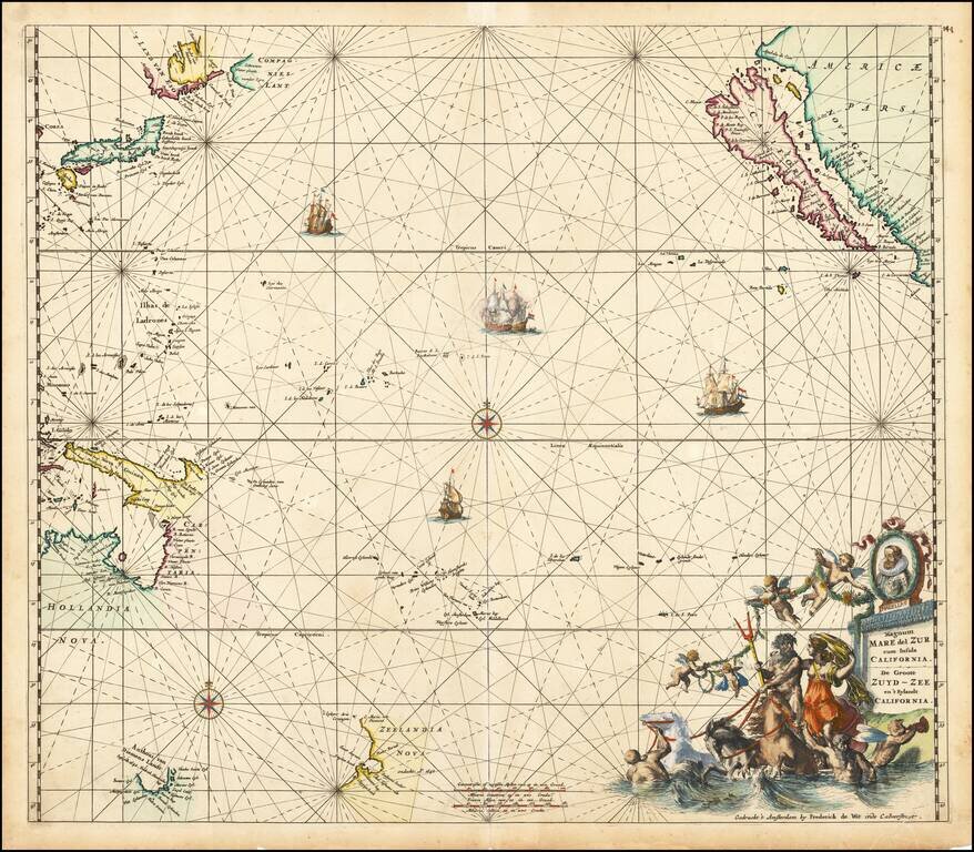
Fine old colored example of first state of De Wit's map of the Pacific Ocean, featuring California as an Island and important early projections of Australia and New Zealand. The finely engraved sea chart was first published in De Wit's Orbis Maritimus...
![Map of Mexico, Central America, and the West Indies [Insets of Bermuda, Sandwich Islands, Jamaica and Panama Railroad]](/map/small/69133.jpg)
Attractive map of Mexico, the Caribbean and the Gulf Coast, published by SA Mitchell Jr. Includes large insets of Cuba, Bermuda, Jamaica, and the Isthmus of Panama and a small inset of Jamaica. Shows shipping routes from New Orleans to points...

Rare map showing the Catholic Missions on New Zealand, the Hawaiian Islands, Tahiti, Samoa, Tonga, New Caledonia, New Hebrides, Fijian Islands, the Marquesas, and a number of other islands, with a general map in the center, published as a Supplement to...
![[Miniature on Vellum in gold and colors] Orbis Nulla Plaga est, Quam Sol non Ditet Jesus](/map/small/62347.jpg)
An Illuminated Manuscript Map of the World on Vellum! Finely executed hand drawn miniature map of the world, celebrating the spread of Catholicism by the Jesuits. A representation of the baby Jesus is shown between the two hemispheres, with the...

Sedition in New York in 1766, The Stamp Act, "America's Nabob", and the Origins of "Yankee Doodle". Rare engraved caricature of William Pitt the Elder, Earl of Chatham, represented as a Colossus straddling the Atlantic Ocean and attempting to gain...

Lively image of a crowd watching the reading of the Declaration of Independence on July 4, 1776. Fine image of the reading of the Declaration of Independence, which appeared in Barnard's New-Completed Authentic History of England. The image is also...
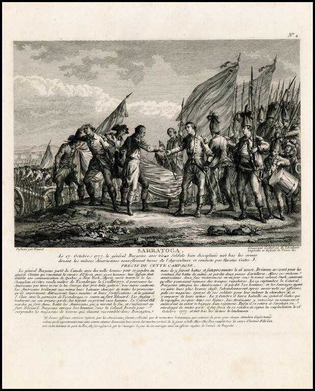
Rare view showing the surrender of General John Burgoyne at the Battle of Saratoga on October 7, 1777, one of the first important American victories during the American Revolution. The view appeared in Nicolas Ponce and Francois Godefroy's Recueil...