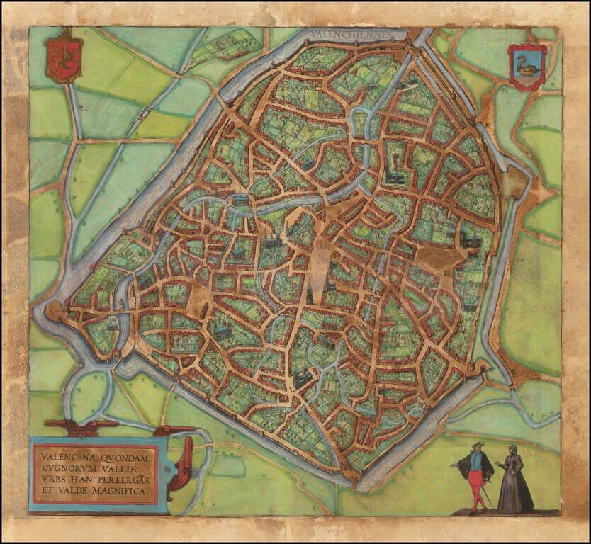
Nice example of this iconic plan of 16th century f Valenciennes, which appeared in Braun & Hogenberg's 6 volume Civititas Orbis Terrarum. The verso translates as follows: The Loire, an exceedingly well-known river in France, flows directly past...
![[Douai] Duacum, Catuarcorum urbs tam situ, quam incolis, et litterarum studijs elegantissime ornata](/map/small/55817mp2.jpg)
Nice example of important plan of 16th century Douai, which appeared in Braun & Hogenberg's 6 volume Civititas Orbis Terrarum.
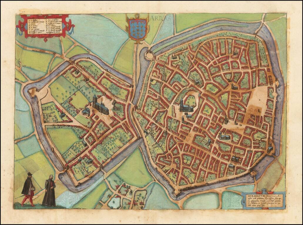
Nice example of this iconic plan of 16th century Arras, which appeared in Braun & Hogenberg's 6 volume Civititas Orbis Terrarum.
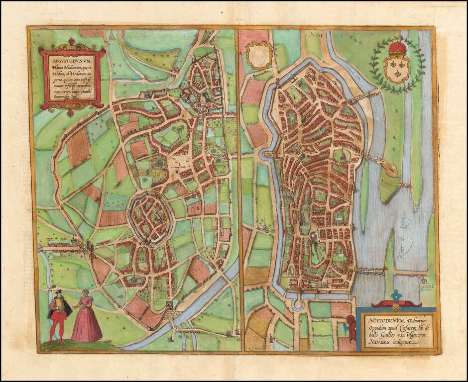
Nice example of these early plans of Autun and Nevers, which appeared in Braun & Hogenberg's 6 volume Civititas Orbis Terrarum.
![Palatinatus Bavariae Descriptio . . . [with] Wirtenbergensis Ducatus...](/map/small/65838.jpg)
Fine pair of maps, published by Abraham Ortelius. Ortelius' map of Bayern is based on the map by Erhart Reich. The map includes Regensberg, Nuremberg and Bamberg. The map of the Rhine, both south and north of Strassbourg is based on Daniel Specklin's...
![Pomeraniae, Wandalicae Regionis Typ [with] Livoniae Nova Descriptio [with] Ducatus Oswieczensis, et Zatoriensis, Descriptio](/map/small/43172.jpg)
Finely colored example of Ortelius' maps of Pomerania, Latvia and part of Southern Poland above the Carpathian Mountains, from Ortelius Theatrum Orbis Terrarum.
![Hassiae Descriptio . . . [with] Holsatiae Descrip.](/map/small/46478.jpg)
Nice pair of regional maps of Germany, including decorative cartouches, etc. The Hassiae map extends to the Rhine and shows Frankfurt, and extends up to the Werra and Fulda Rivers. The Holsatiae map extends from Hamburg and Louwenburg in the south to...
![Thietmarsiae, Holsaticae Regionis Partis Typus Auctore Petro Boeckel [with] Prussia Descriptio ante aliquot annos ab Henrico Zellio ab coque D. Ioanni Clur. civi Gedanesi Ded:](/map/small/45904.jpg)
Ortelius’ Maps of Prussia and Holstein, from the First Modern Atlas Fine maps of Prussia and Holstein, printed on the same plate, that featured in Ortelius’ famous and groundbreaking atlas Theatrum Orbis Terrarum. The map on the right shows...
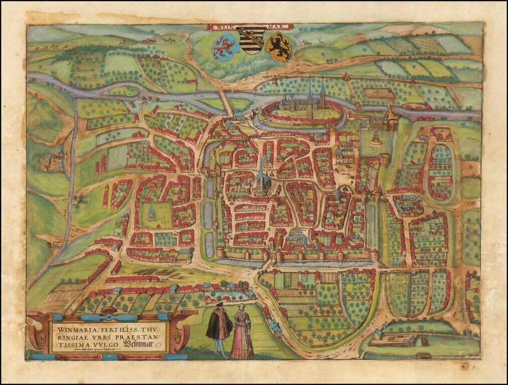
Old color example of Braun & Hogenberg's important early view of Weimar, crediting Johan Wolfius, Rector of the Gymnasium at Ratisbona (Regensburg).
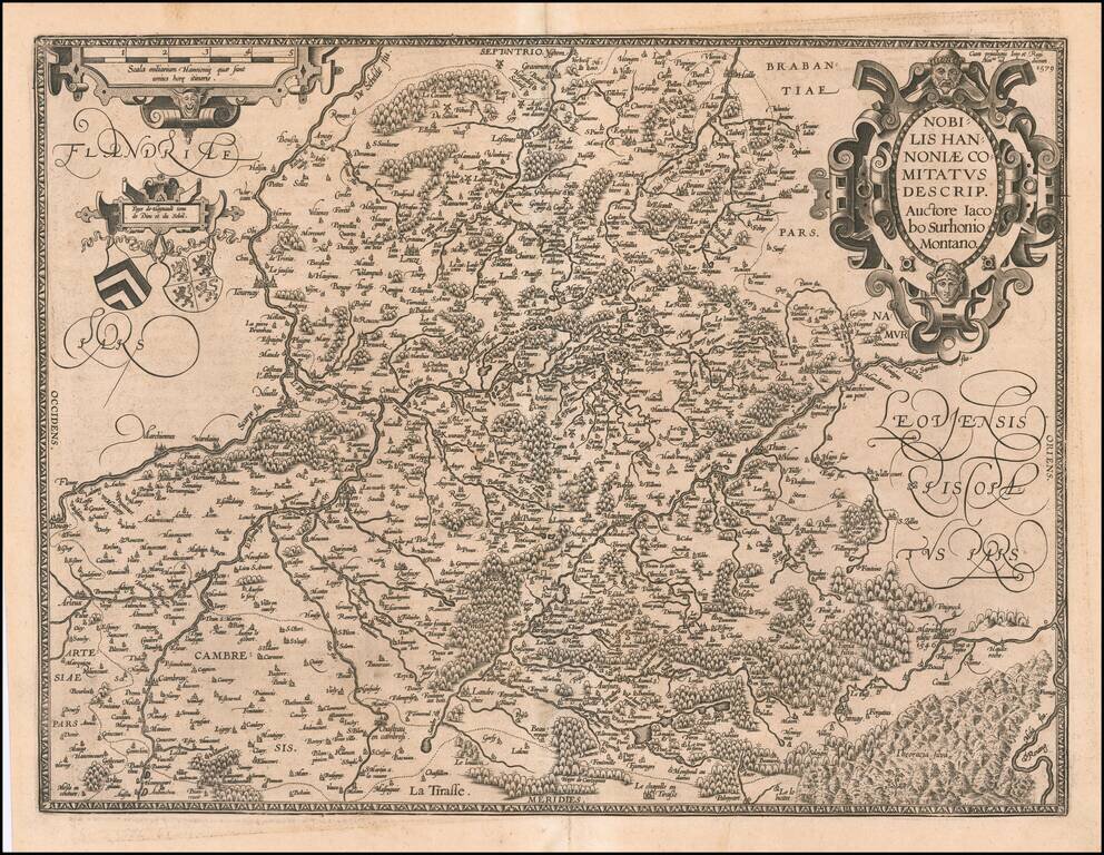
Striking example of Ortelius' map of Hannonia (Hainaut), with ornate cartouches, two coats of arms, etc. Includes the cities of Charleroi, Mons, Ath, Tournay, Valenciennes, Maubeuge, etc. Nice dark impression and wide margins.
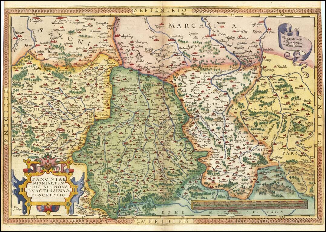
Nice example of Ortelius' regional map of Germany, extending from Prague to Berlin and Brandenberg, and from Mulhausen and Erpach to Goltberg, Sagan, Furstenberg, Leipzig and Frankfurt am Oder. Wide margins and nice old color. From the 1581 French...
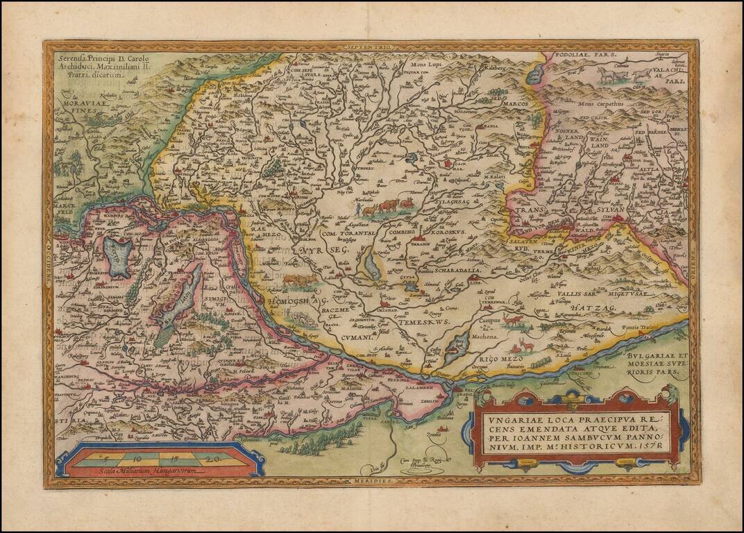
Nice full color example of Ortelius' map of Hungary and surrounding regions. Highly detailed regional map with decorative cartouche, coat of arms and migratory animals in the middle of the map. The map appeared in Ortelius' Theatrum Orbis Terrarum,...
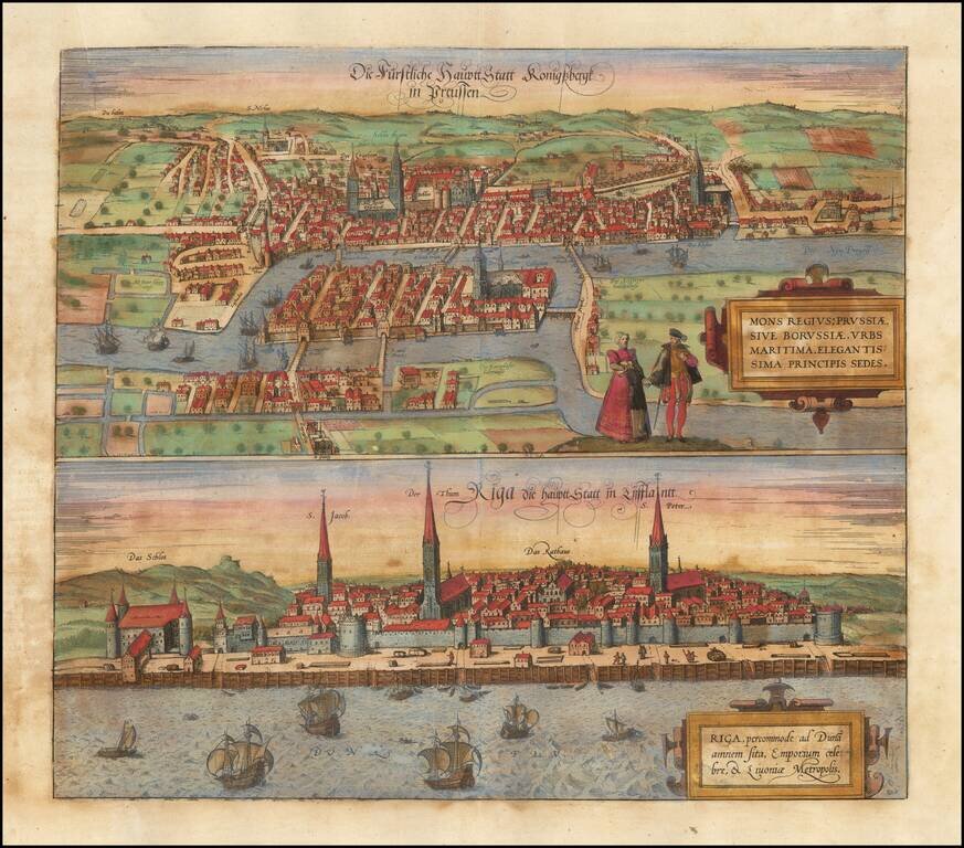
Fine early views of Kalingrad and Riga, first published by Braun & Hogenberg in 1581. The view is one of the earliest obtainable views of Kalingrad and Riga.
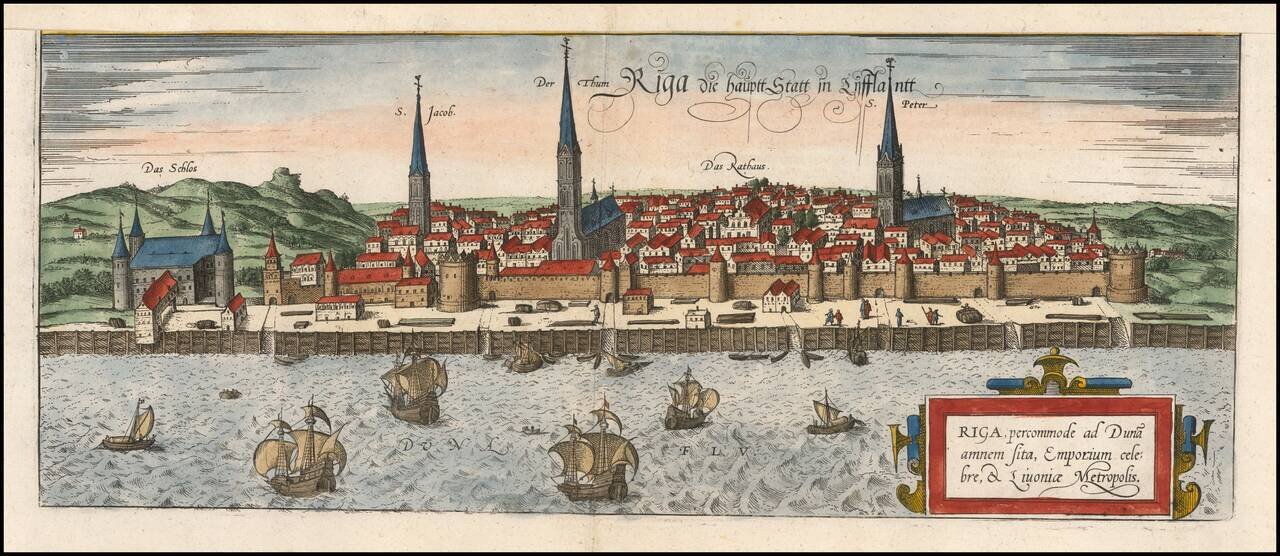
A fine early view of Riga, first published by Braun and Hogenberg in 1581. This is one of the earliest obtainable views of the city and was heavily based on Munster's slightly earlier map of the city. This map appeared in Braun and Hogenberg's...
![Insularum Aliquot Maris Mediterranei Descriptio [Sicily, Malta, Sardinia, Corfu, Elba and Zerbia]](/map/small/45115.jpg)
Fine example of Ortelius' maps of the islands of Sicily, Malta, Sardinia, Corfu, Elba and Zerbia, from the Ortelius' Theatrum Orbis Terrarum, the first modern Atlas of the World. Includes a number of sailing ships, including a sinking vessel off...
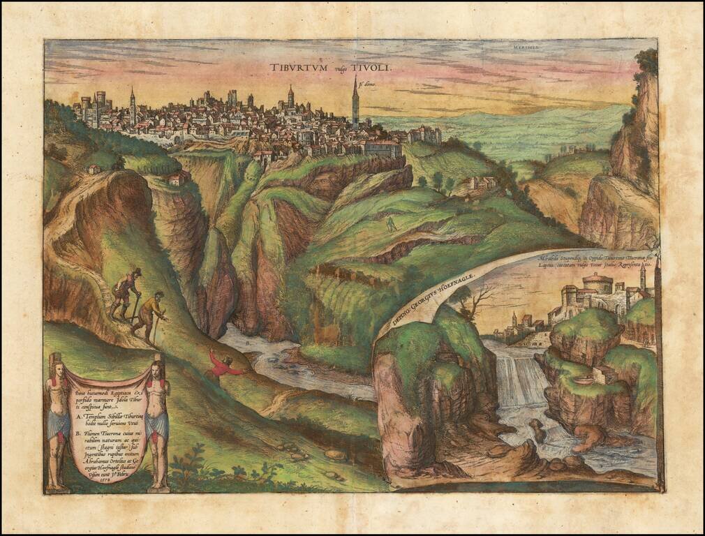
The city of Tivoli, shown from Mount Tiburtini, with an inset of the famous cascading waterfalls. In the foreground, illustrations of 3 climbers include Hoefnagel and Abraham Ortelius, who visited the town and studied it in 1578, as noted in the...