Map size in jpg-format: 20.3834MiB
Click to open in high resolution (open in new tab).
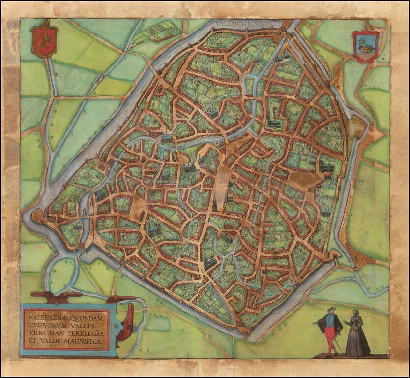
Nice example of this iconic plan of 16th century f Valenciennes, which appeared in Braun & Hogenberg's 6 volume Civititas Orbis Terrarum.
The verso translates as follows:
The Loire, an exceedingly well-known river in France, flows directly past the city and is very beneficial for trade. The fields surrounding the city are very fertile, and for this reason the city is also called the granary throughout France, just as in earlier times Sicily was the granary of Rome. A famous wine also grows in this soil, which is exported from here not only throughout France but to all the countries in Europe. [...] The French spoken here is pure and uncorrupted, which is also the reason why so many foreigners settle here. For some are here for trade, others for study and others again to acquire the language, but also many without doubt for both these last two reasons, [...] and Germans in particular send their children here."Orléans is shown here in an extraordinarily precise bird's-eye perspective that incorporates elevations of the city's many churches and monasteries, including the cathedral of Sainte-Croix, destroyed by the Huguenots a few years earlier.
Georg Braun (1541-1622) was born and died in Cologne. His primary vocation was as Catholic cleric; he spent thirty-seven years as canon and dean at the church St. Maria ad Gradus, in Cologne. Braun was the chief editor of the Civitates orbis terrarum, the greatest book of town views ever published. His job entailed hiring artists, acquiring source material for the maps and views, and writing the text. In this role, he was assisted by Abraham Ortelius. Braun lived into his 80s, and he was the only member of the original team to witness the publication of the sixth volume in 1617.
If you are a student, write to us in telegram: @antiquemaps and indicate what material you need and for what work you need a map in high detail. We are ready to provide material on special terms. For students only!
![Carte d'Etude [Study Map]](/map/small/66795.jpg)
![Orange [Vauban Style Fortress]](/map/small/62043.jpg)
