logo

1584. Zee Caerte vande Custe va Lijfflandt begrepen Rontsome de grooten Inham vande Rijgschezee, Soe tselsde hem verthoont en op doet -- Orae maritimae Livoniae, ab complectentis Rigani maris Sinium magnu . . .

  • Zee Caerte vande Custe va Lijfflandt begrepen Rontsome de grooten Inham vande Rijgschezee, Soe tselsde hem verthoont en op doet --  Orae maritimae Livoniae, ab complectentis Rigani maris Sinium magnu . . .

Zee Caerte vande Custe va Lijfflandt begrepen Rontsome de grooten Inham vande Rijgschezee, Soe tselsde hem verthoont en op doet -- Orae maritimae Livoniae, ab complectentis Rigani maris Sinium magnu . . . information:

Year of creation: 
Resolution size (pixels): 
 12831x8460 px
Disk Size: 
 29.8484MiB
Number of pages: 
 1
Place: 
 Antwerp

Print information. Print size (Width x height in inches):
Printing at 72 dpi 
  178.21 х 117.5
Printing at 150 dpi 
 85.54 х 56.4
Printing at 300 dpi 
 42.77 х 28.2

An example of detailing the file of this map of in a printable high-resolution:

Click to open in high resolution (open in new tab).
Attention! this is just the central piece (central area 960x960 px) of the map file!
This is an example, so that you can see and study the level of detail of a given map. The entire Map will be fully available after payment!

Zee Caerte vande Custe va Lijfflandt begrepen Rontsome de grooten Inham vande Rijgschezee, Soe tselsde hem verthoont en op doet --  Orae maritimae Livoniae, ab complectentis Rigani maris Sinium magnu . . .

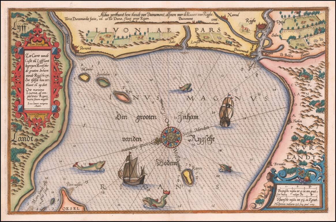
Striking example of Wagenhaer's map of the coast of Latvia, including the area around Riga and part of Curland.

Includes sea monsters, sailing ships, compass rose, decorative cartouche, anchorages and soundings. Wagenhaer was a Dutch pilot who produced the first set of effective navigational charts, under the title Spiegel der Zeevaerdt.

These gorgeous charts, engraved by Baptist and Jan van Doetecum, embody the latest contemporary knowledge of navigation and position finding and set the standard which was followed for more than a century. Waghenaer's charts are magnificent works of art, which are highly sought after by collectors. An essential map for collectors of the region and the earliest decorative sea chart of the area.


Special conditions for students!

If you are a student, write to us in telegram: @antiquemaps and indicate what material you need and for what work you need a map in high detail. We are ready to provide material on special terms. For students only!

Item information:

Year of creation:
Size:
12831x8460 px
Disk:
29.8484MiB
Number of pages:
1
Place:
Antwerp
Author:
Lucas Janszoon Waghenaer.
$14.99

Related item