Map size in jpg-format: 1.71667MiB
Click to open in high resolution (open in new tab).
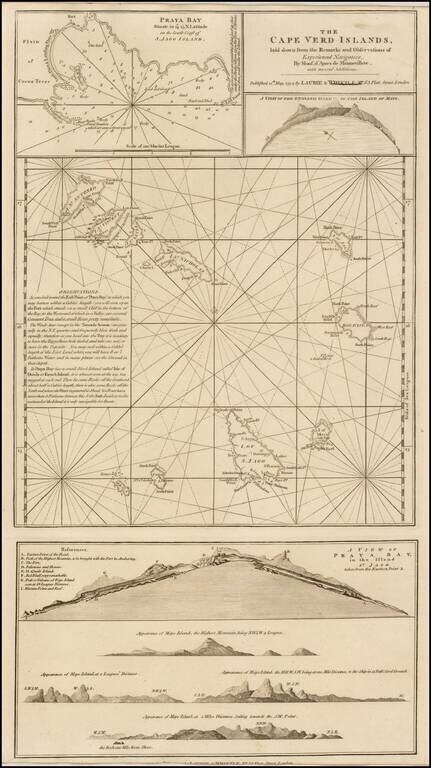
A finely detailed chart of the Cape Verde Islands off the Coast of Africa, which appeared in a later edition of the West India Atlas.
This sheet of sea charts details the Cape Verde Islands. First settled by the Portuguese in 1462, it soon became a popular haunt for pirates, including Sir Francis Drake in the 1580s.
The sheet features with inset maps of Praya Bay, A View of the English Road, A View of Praya Bay and a group of recognition views. Sayer and Bennet based their work on charts by Jean-Baptiste Mannevillettes's Le Neptune Oriental (Paris, 1745).
Richard Holmes Laurie (1777-1858) was the son of mezzotint engraver Robert Laurie, who had taken over Robert Sayer's publishing house with James Whittle in 1794. Richard Holmes Laurie joined in a partnership with Whittle when his father retired in 1812. The name of the firm then switched from Laurie & Whittle to Whittle & Laurie. Whittle died in 1818, leaving Richard Holmes to continue publishing alone as R. H. Laurie.
When the Hydrographic Office opened in 1795, it was tasked with creating and producing all the nautical charts for the Royal Navy so as to wean the Navy off dependence on foreign charts. By the 1820s, private publishers were augmenting HO charts and competing with them, including Richard Holmes Laurie. Richard gave up publishing anything except nautical materials by 1830. He also sold charts to Trinity House, the lighthouse and maritime safety fraternity. He died in 1858.
The firm continued to print under the name R.H. Laurie even after 1858. Later, the firm was managed by Laurie’s draughtsman, Alexander George Findlay, and, later, Daniel and William Kettle.
If you are a student, write to us in telegram: @antiquemaps and indicate what material you need and for what work you need a map in high detail. We are ready to provide material on special terms. For students only!

![[Ascension Island] The True Description of the Island of Ascention lyeing under 8 degrees on ye South syde of ye Equinoctiall lyne.](/map/small/69468.jpg)