Richard Holmes Laurie (1777-1858) was the son of mezzotint engraver Robert Laurie, who had taken over Robert Sayer's publishing house with James Whittle in 1794. Richard Holmes Laurie joined in a partnership with Whittle when his father retired in 1812. The name of the firm then switched from Laurie & Whittle to Whittle & Laurie. Whittle died in 1818, leaving Richard Holmes to continue publishing alone as R. H. Laurie.
When the Hydrographic Office opened in 1795, it was tasked with creating and producing all the nautical charts for the Royal Navy so as to wean the Navy off dependence on foreign charts. By the 1820s, private publishers were augmenting HO charts and competing with them, including Richard Holmes Laurie. Richard gave up publishing anything except nautical materials by 1830. He also sold charts to Trinity House, the lighthouse and maritime safety fraternity. He died in 1858.
The firm continued to print under the name R.H. Laurie even after 1858. Later, the firm was managed by Laurie’s draughtsman, Alexander George Findlay, and, later, Daniel and William Kettle.

An 18th Century English Wall Map of Asia, Australia & The Indian Ocean Nice example of the 6 sheet Laurie and Whittle wall map of Asia, Australia and the Indian Ocean, first published in Asia in 1794. The map in its complete state covers an area...
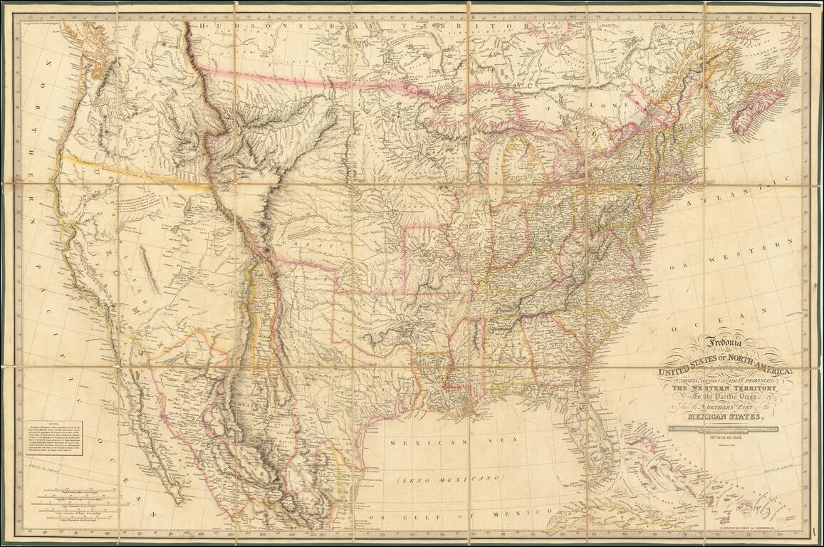
Rare 1836 edition of Laurie's Fredonia, which has been substantially updated in Texas and the West. First issued in 1830, the map faithfully incorporates information from all important early explorations, including Lewis & Clark, Stephen Long, and...
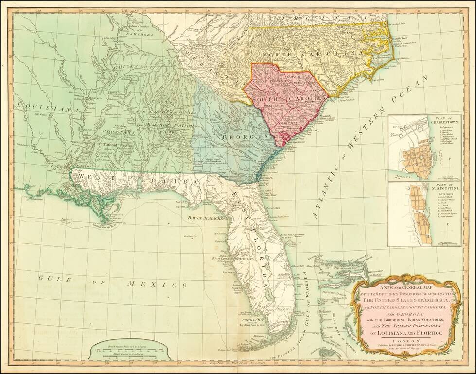
A Fine 18th Century Map of the Southern United States & Florida with Early Plans of Charleston and St. Augustine Laurie & Whittle's edition of this scarce map of the Southern States and Florida, originally compiled by Bernard Romans for the...
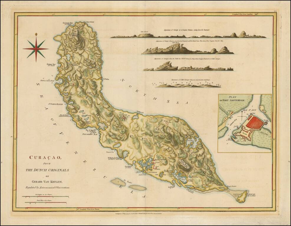
Nice example of Laurie & Whittle's map of Curacao. Includes numerous profile views and a large inset of Fort Amsterdam.
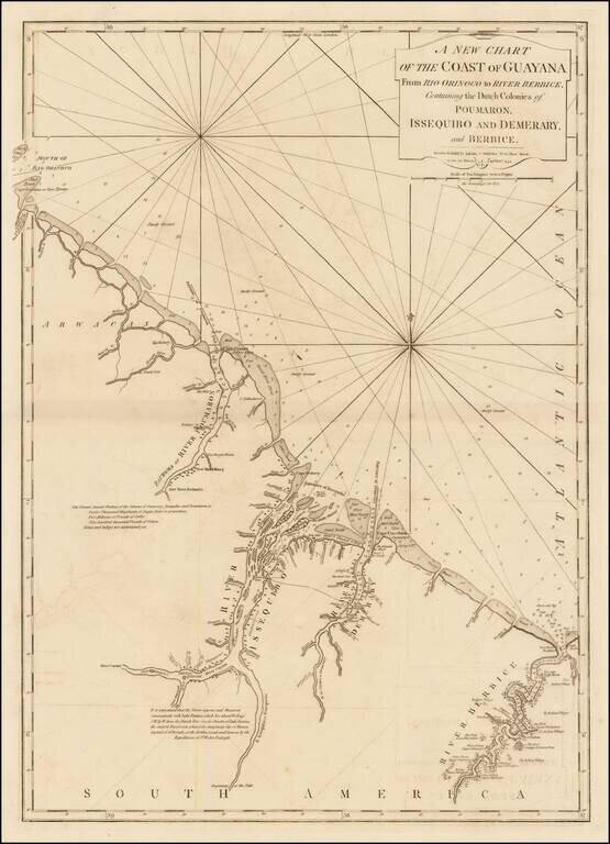
Significantly revised and updated version of Laurie & Whittle's chart of the Dutch Colony of Guayana, from Jeffery's West India Atlas. The present chart has been significatnly updated from earlier editions.
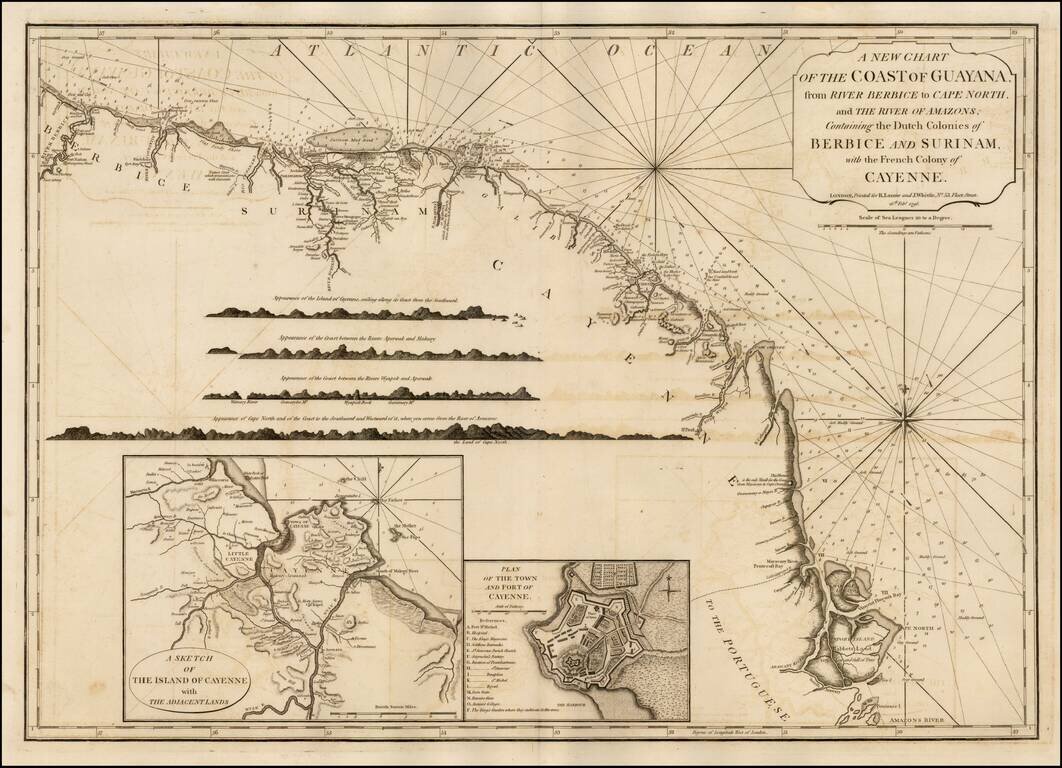
Significantly revised and updated version Laurie & Whittle's chart of the Dutch and French Colonies in Guayana, from Jeffery's West India Atlas.
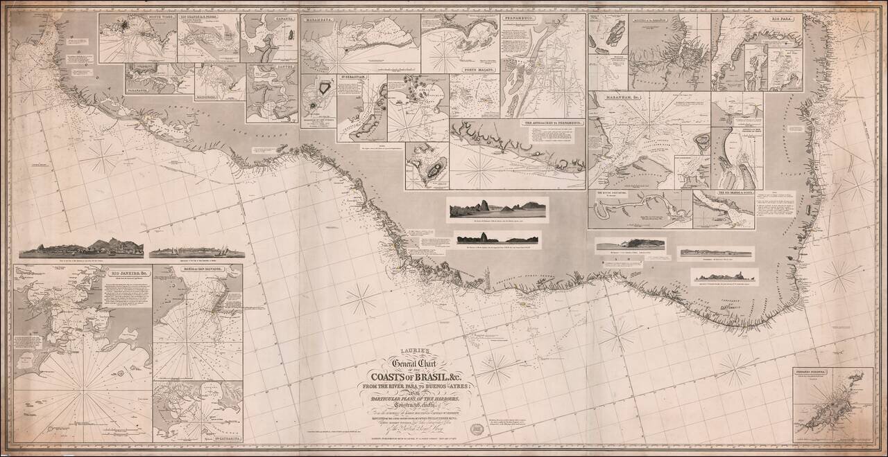
Fine large format sea chart of the coast of Brazil and Paraguay, published by Richard Laurie in London. The map includes inset plans of a number of Brazilian and other harbors, including: Rio de Janeiro Bahia San Salvador Montevideo Rio Grande...
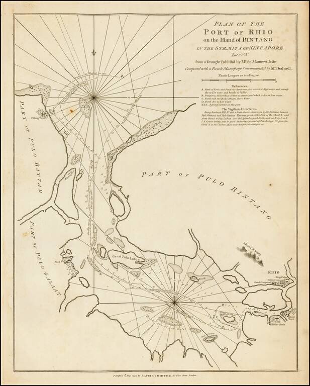
A fine large format 18th-century sea chart of Bintan and Batam Islands, Indonesia, located on the Singapore Straits, published by the firm of Laurie & Whittle. Bintan Island (formerly known as Bintang) and the adjacent island of Batam (Bataam) are...
![[Papua New Guinea, etc.] A New Chart of the Straits to the Westward of New Guinea; Comprehending The Straits of New Guinea, Revenge's or Galewo Straits, Pitt's or Sagewin Straits, Dampier's or Gamen Straits, with Bougainville's Passage . . . Captn. M. Hog](/map/small/39549.jpg)
Rare sea chart of West Papua, New Guinea, Waigeo, Pulau Raja, Pulau Sanjang, Pulau Aju, etc., published by Laurie & Whittle in London, based upon the surveys under the command of Captain Robert Williams aboard the Thames (1796 - 1797) and Captain...
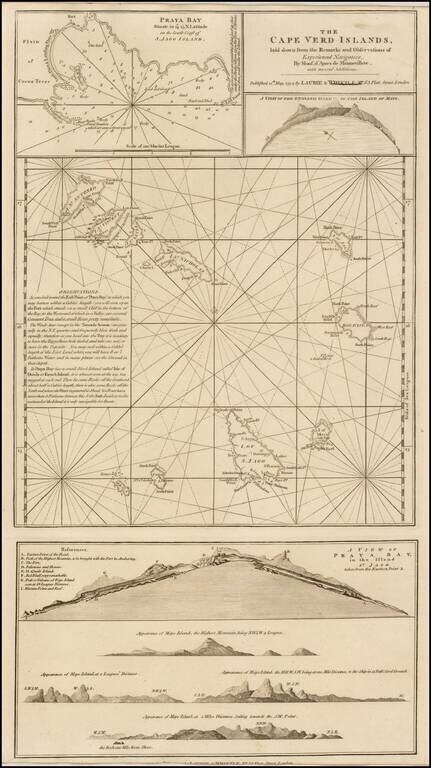
A finely detailed chart of the Cape Verde Islands off the Coast of Africa, which appeared in a later edition of the West India Atlas. This sheet of sea charts details the Cape Verde Islands. First settled by the Portuguese in 1462, it soon became a...