logo

1682. Russia Alba or Moscovia... | The Dominions of the Czar of Russia Alba or Great Duke of Moscovia in which ar the Dukedoms of Moscow, Wolodimer, Rezan, Worotin, Novogorod-Sewierski, Czernihow, Smolensko, Reschow, Twer, Novogorod-Weliki, Biele Jezora, Wologd

  • Russia Alba or Moscovia... | The Dominions of the Czar of Russia Alba or Great Duke of Moscovia in which ar the Dukedoms of Moscow, Wolodimer, Rezan, Worotin, Novogorod-Sewierski, Czernihow, Smolensko, Reschow, Twer, Novogorod-Weliki, Biele Jezora, Wologd

Russia Alba or Moscovia... | The Dominions of the Czar of Russia Alba or Great Duke of Moscovia in which ar the Dukedoms of Moscow, Wolodimer, Rezan, Worotin, Novogorod-Sewierski, Czernihow, Smolensko, Reschow, Twer, Novogorod-Weliki, Biele Jezora, Wologd information:

Year of creation: 
Resolution size (pixels): 
 21296x13841 px
Disk Size: 
 90.2913MiB
Number of pages: 
 1
Place: 
 London
Author: 

Print information. Print size (Width x height in inches):
Printing at 72 dpi 
  295.78 х 192.24
Printing at 150 dpi 
 141.97 х 92.27
Printing at 300 dpi 
 70.99 х 46.14

An example of detailing the file of this map of in a printable high-resolution:

Click to open in high resolution (open in new tab).
Attention! this is just the central piece (central area 960x960 px) of the map file!
This is an example, so that you can see and study the level of detail of a given map. The entire Map will be fully available after payment!

Russia Alba or Moscovia... | The Dominions of the Czar of Russia Alba or Great Duke of Moscovia in which ar the Dukedoms of Moscow, Wolodimer, Rezan, Worotin, Novogorod-Sewierski, Czernihow, Smolensko, Reschow, Twer, Novogorod-Weliki, Biele Jezora, Wologd

First state.

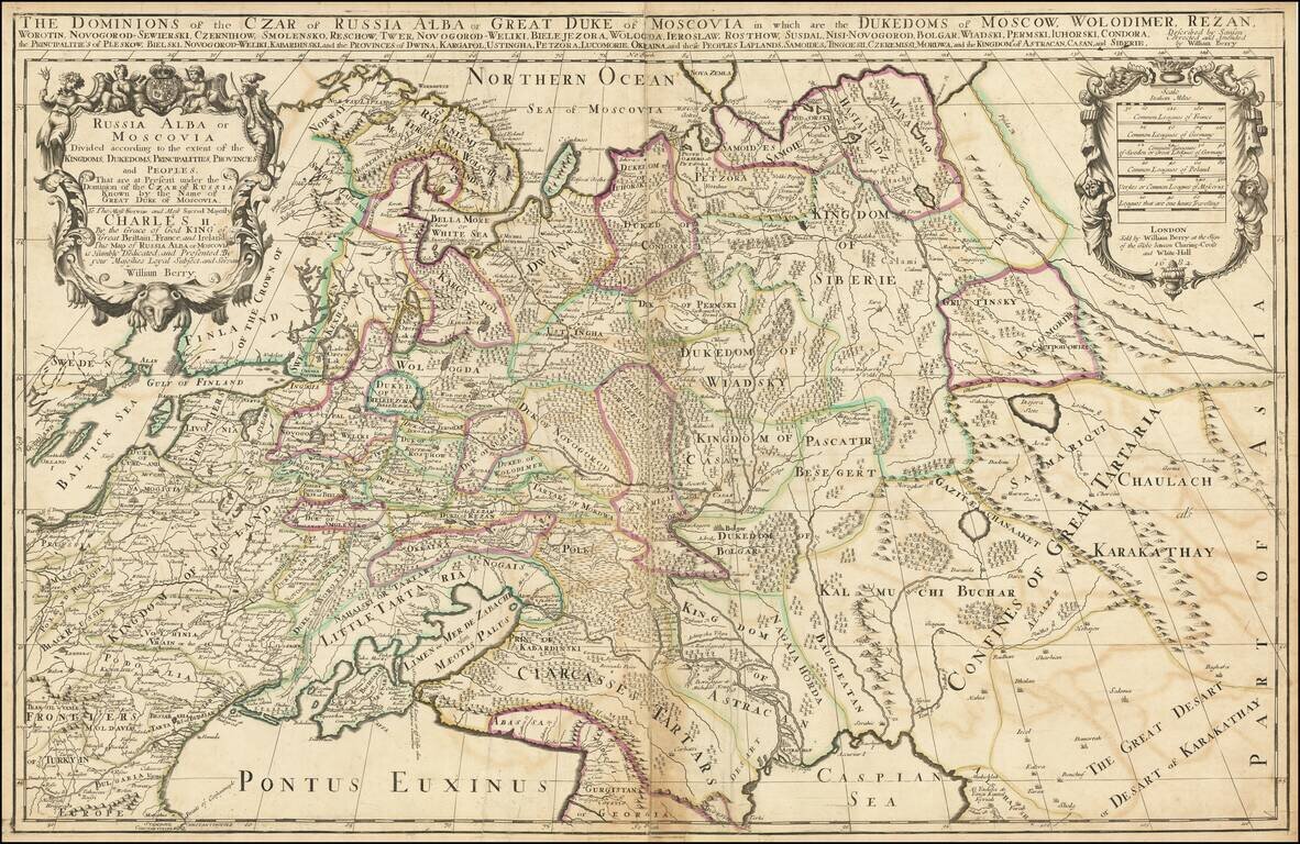
Impressive two-sheet engraved antique map of Russia, published by the 17th century London mapmaker William Berry in 1682.

The map covers all of Russia to the Ural Mountains and also depicts a large Kingdom of Poland dominating most of Eastern Europe.

The map was issued in two known states, this being the first.

The map is dedicated to King Charles II, who ruled England until his death in 1685. Many of Berry's pre-1685 maps are dedicated to Charles II.

Many of Berry's maps are derived from Sanson via Jaillot and the same is true of this map.


Special conditions for students!

If you are a student, write to us in telegram: @antiquemaps and indicate what material you need and for what work you need a map in high detail. We are ready to provide material on special terms. For students only!

Item information:

Year of creation:
Size:
21296x13841 px
Disk:
90.2913MiB
Number of pages:
1
Place:
London
Author:
William Berry.
$21.99

Related item