Map size in jpg-format: 54.9184MiB
Click to open in high resolution (open in new tab).
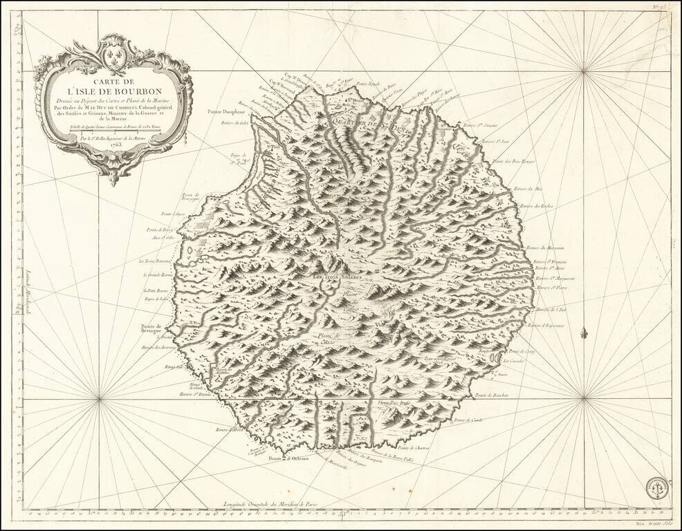
Fine French Sea Chart of Reunion Island
Finely executed sea chart of the Island of Bourbon (Reunion Island), first issued in 1763.
Rumsey notes:
"Exceptional onboard document of this rare and fabulous maritime atlas, a masterpiece by the greatest French hydrographer of the 18th century, with maps of all the coastlines known at the time. Bound with the coat of arms of the King of France, the atlas was taken by the English aboard the frigate la Nymphe, off the coasts of Ushant August 10, 1780, during one of the naval battles of the American War of Independence which took place on European waters. In the context of the war at the end of the 18th century, and of the rivalry between the French and British Navy, maritime atlases, were strategic tools, and this “Hydrographie Françoise” more so than any other, because its purpose was to provide the best maritime charts for the French ships that were fighting on the American side against the British. (The handwritten captions throughout most of the atlas are prices for individual maps and all include the same mention: “for sailors”). These atlases were not the kind to be kept in a library, but precious tools, based on the observations of the travelers and continuously improved upon, as reflect in the present copy. It was bound with the engraved title page of the edition of 1737-1765, but the index includes maps printed after 1765 (until 1772), and the copy was augmented by six maps that do not appear in the index (until 1776), as well as 14 pages of text from the Versailles edition of 1773. The later maps are signed by Verdun de la Crenne and were done during the campaigns of the Flore (1771-1772) and of the Isis led by Fleurieu in 1768-1769. The captions explain that the maps were created using the latest technology of the day that could measure longitude (maritime clocks)." (Continued in the Pub Note field).
The Dépôt de la Marine, known more formally as the Dépôt des cartes et plans de la Marine, was the central charting institution of France. The centralization of hydrography in France began in earnest when Jean-Baptiste Colbert became First Minister of France in 1661. Under his watch, the first Royal School of Hydrography began operating, as did the first survey of France’s coasts (1670-1689). In 1680, Colbert consolidated various collections of charts and memoirs into a single assemblage, forming the core of sources for what would become the Dépôt.
The Dépôt itself began as the central deposit of charts for the French Navy. In 1720, the Navy consolidated its collection with those government materials covering the colonies, creating a single large repository of navigation. By 1737, the Dépôt was creating its own original charts and, from 1750, they participated in scientific expeditions to determine the accurate calculation of longitude.
In 1773, the Dépôt received a monopoly over the composition, production, and distribution of navigational materials, solidifying their place as the main producer of geographic knowledge in France. Dépôt-approved charts were distributed to official warehouses in port cities and sold by authorized merchants. The charts were of the highest quality, as many of France’s premier mapmakers worked at the Dépôt in the eighteenth century, including Philippe Bauche, Jacques-Nicolas Bellin, Rigobert Bonne, Jean Nicolas Buache, and Charles-François Beautemps-Beaupré.
The Dépôt continued to operate until 1886, when it became the Naval Hydrographic Service. In 1971, it changed names again, this time to the Naval and Oceanographic Service (SHOM). Although its name has changed, its purpose is largely the same, to provide high quality cartographic and scientific information to the France’s Navy and merchant marine.
If you are a student, write to us in telegram: @antiquemaps and indicate what material you need and for what work you need a map in high detail. We are ready to provide material on special terms. For students only!

![[Ascension Island] The True Description of the Island of Ascention lyeing under 8 degrees on ye South syde of ye Equinoctiall lyne.](/map/small/69468.jpg)