Map size in jpg-format: 20.9157MiB
Click to open in high resolution (open in new tab).
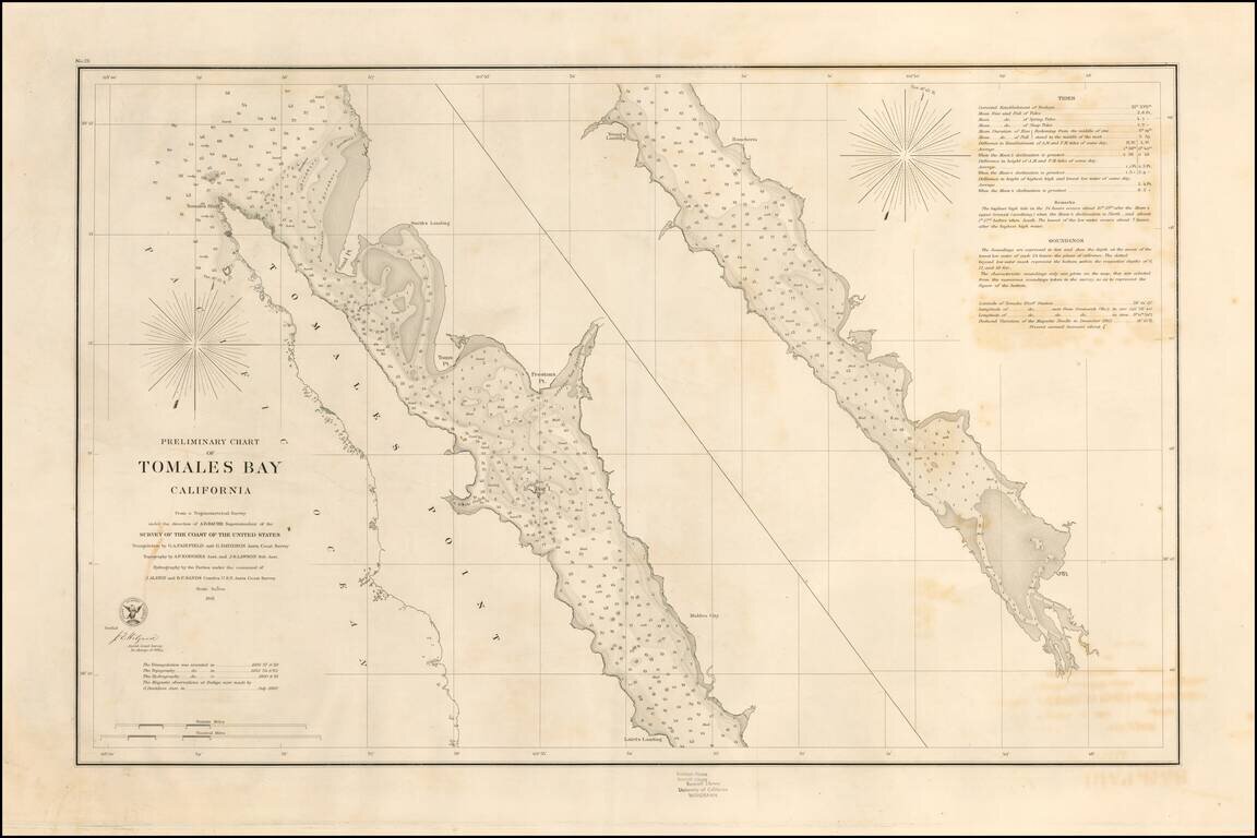
Rare separately pubilshed thick paper example of George Davidson's copy of the US Coast Survey Chart of Tomales Bay, first published in 1861.
Tomales Bay's history is quite interesting, having been discovered by the English in the 16th Century, visited by the Spanish in the early 17th Century and briefly settled by the Russians in the early 19th Century.
Francis Drake is thought to have landed in nearby Drakes Estero in 1579. The Vizcaíno Expedition also located the Bay in 1603, and thinking it a river, named it Rio Grande de San Sebastian.
Early 19th-century settlements constituted the southernmost Russian colony in North America and were spread over an area stretching from Point Arena to Tomales Bay.
The United States Office of the Coast Survey began in 1807, when Thomas Jefferson founded the Survey of the Coast. However, the fledgling office was plagued by the War of 1812 and disagreements over whether it should be civilian or military controlled. The entity was re-founded in 1832 with Ferdinand Rudolph Hassler as its superintendent. Although a civilian agency, many military officers served the office; army officers tended to perform the topographic surveys, while naval officers conducted the hydrographic work.
The Survey’s history was greatly affected by larger events in American history. During the Civil War, while the agency was led by Alexander Dallas Bache (Benjamin Franklin’s grandson), the Survey provided the Union army with charts. Survey personnel accompanied blockading squadrons in the field, making new charts in the process.
After the Civil War, as the country was settled, the Coast Survey sent parties to make new maps, employing scientists and naturalists like John Muir and Louis Agassiz in the process. By 1926, the Survey expanded their purview further to include aeronautical charts. During the Great Depression, the Coast Survey employed over 10,000 people and in the Second World War the office oversaw the production of 100 million maps for the Allies. Since 1970, the Coastal and Geodetic Survey has formed part of the National Oceanic and Atmospheric Administration (NOAA) and it is still producing navigational products and services today.
If you are a student, write to us in telegram: @antiquemaps and indicate what material you need and for what work you need a map in high detail. We are ready to provide material on special terms. For students only!

![[Chinese-Language San Francisco Chinatown Business Directory and Lunar Calendar for 1892]](/map/small/66981jc.jpg)
![[San Francisco Fire Satirical Cartoon] Uncle Sam --](/map/small/70102.jpg)