logo

1907. Plat Showing center line of property leased from Pacific Sand and Gravel Co. for Spur Track - Monrovia Line - Pacific Elecric Railway Jan 1 - 1910

  • Plat Showing center line of property leased from Pacific Sand and Gravel Co. for Spur Track - Monrovia Line - Pacific Elecric Railway Jan 1 - 1910

Plat Showing center line of property leased from Pacific Sand and Gravel Co. for Spur Track - Monrovia Line - Pacific Elecric Railway Jan 1 - 1910 information:

Year of creation: 
Resolution size (pixels): 
 1759x2651 px
Disk Size: 
 756722B
Number of pages: 
 1
Place: 
 n.p.

Print information. Print size (Width x height in inches):
Printing at 72 dpi 
  24.43 х 36.82
Printing at 150 dpi 
 11.73 х 17.67
Printing at 300 dpi 
 5.86 х 8.84

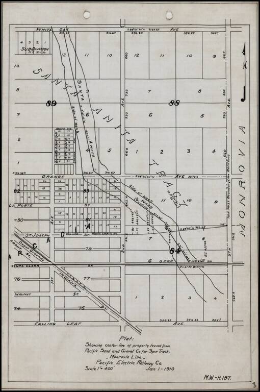
Detailed internal sketch map of the Pacific Electric Railway lines in Arcadia, California.

Shows Depot Grounds of the ATS&F, Southern Pacific Railroad's Duarte Branch, a portion of the Santa Anita River and a street plan, centered on 2nd Avenue and Orange Avenue.


Special conditions for students!

If you are a student, write to us in telegram: @antiquemaps and indicate what material you need and for what work you need a map in high detail. We are ready to provide material on special terms. For students only!

Item information:

Year of creation:
Size:
1759x2651 px
Disk:
756722B
Number of pages:
1
Place:
n.p.
Author:
Pacific Electric Railway.
$9.99

Related item