logo

1670. Pascaerte vande Oost Zee: van't Eylandt Ruygen ofte Bornholm tot aen Wyborgh.

  • Pascaerte vande Oost Zee: van't Eylandt Ruygen ofte Bornholm tot aen Wyborgh.

Pascaerte vande Oost Zee: van't Eylandt Ruygen ofte Bornholm tot aen Wyborgh. information:

Year of creation: 
Resolution size (pixels): 
 13443x10687 px
Disk Size: 
 41.0462MiB
Number of pages: 
 1
Place: 
 Amsterdam
Author: 

Print information. Print size (Width x height in inches):
Printing at 72 dpi 
  186.71 х 148.43
Printing at 150 dpi 
 89.62 х 71.25
Printing at 300 dpi 
 44.81 х 35.62

An example of detailing the file of this map of in a printable high-resolution:

Click to open in high resolution (open in new tab).
Attention! this is just the central piece (central area 960x960 px) of the map file!
This is an example, so that you can see and study the level of detail of a given map. The entire Map will be fully available after payment!

Pascaerte vande Oost Zee: van't Eylandt Ruygen ofte Bornholm tot aen Wyborgh.

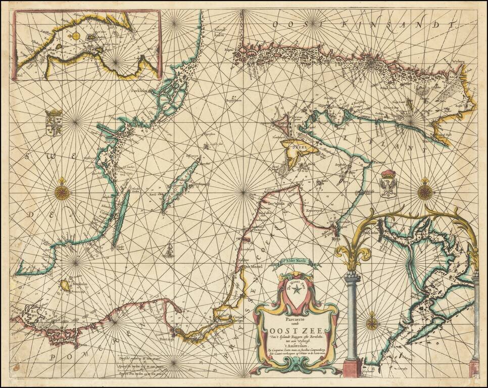
Exceptionally rare chart of the Baltic Sea and adjoining coastlines published by Caspar Lootsman (here "Casparus Loots-man") in Amsterdam.

The chart shows the Baltic Sea from Trelleborg to Rugen at the west and the easternmost section of the Gulf of Finland in the east. The map does not extend far into the Gulf of Bothnia in the north.

Stockholm is labeled, as is Riga ("Ryga"), and Tallin ("Revel").

Another edition of the plate is signed by Johannes van Loon. The plate probably went from van Loon to either Caspar's father or Caspar directly.

The chart follow in the tradition of Colom and Doncker's maps of the Baltic.


Special conditions for students!

If you are a student, write to us in telegram: @antiquemaps and indicate what material you need and for what work you need a map in high detail. We are ready to provide material on special terms. For students only!

Item information:

Year of creation:
Size:
13443x10687 px
Disk:
41.0462MiB
Number of pages:
1
Place:
Amsterdam
Author:
Caspar Lootsman.
$14.99

Related item