logo

1865. (Northern Michican -- Cheboygan to Mullet Lake)

  • (Northern Michican -- Cheboygan to Mullet Lake)

(Northern Michican -- Cheboygan to Mullet Lake) information:

Year of creation: 
Resolution size (pixels): 
 2518x3623 px
Disk Size: 
 1.64674MiB
Number of pages: 
 1
Place: 
 n.p.
Author: 

Print information. Print size (Width x height in inches):
Printing at 72 dpi 
  34.97 х 50.32
Printing at 150 dpi 
 16.79 х 24.15
Printing at 300 dpi 
 8.39 х 12.08

An example of detailing the file of this map of in a printable high-resolution:

Click to open in high resolution (open in new tab).
Attention! this is just the central piece (central area 960x960 px) of the map file!
This is an example, so that you can see and study the level of detail of a given map. The entire Map will be fully available after payment!

(Northern Michican -- Cheboygan to Mullet Lake)

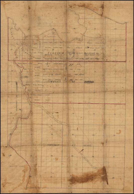
Finely drafted map of part of Cheboygan County in northern Michigan, likely drafted by a local surveyor.

Place names include:

  • Village of Cheboygan
  • Township of Benton
  • Township of Duncan
  • Township of Grant
  • Township of Inverness

Information on the map suggests it was drafted no earlier than the mid-1860s.

  • Thompson Smith acquired Jeremiah Duncan's mill property at Duncan Bay after Duncan's death in 1854.
  • The Property at the east side of the mouth of the Cheboygan River is owned by S(anford) Baker. Baker acquired this property which housed a steam saw mill in the fall of 1866.
  • McArthur Smith & Co., another large landowner, began business by the beginning of 1868.


Special conditions for students!

If you are a student, write to us in telegram: @antiquemaps and indicate what material you need and for what work you need a map in high detail. We are ready to provide material on special terms. For students only!

Item information:

Year of creation:
Size:
2518x3623 px
Disk:
1.64674MiB
Number of pages:
1
Place:
n.p.
Author:
Anonymous.
$14.99

Related item