Map size in jpg-format: 48.6234MiB
Click to open in high resolution (open in new tab).
Fine Original Color Example
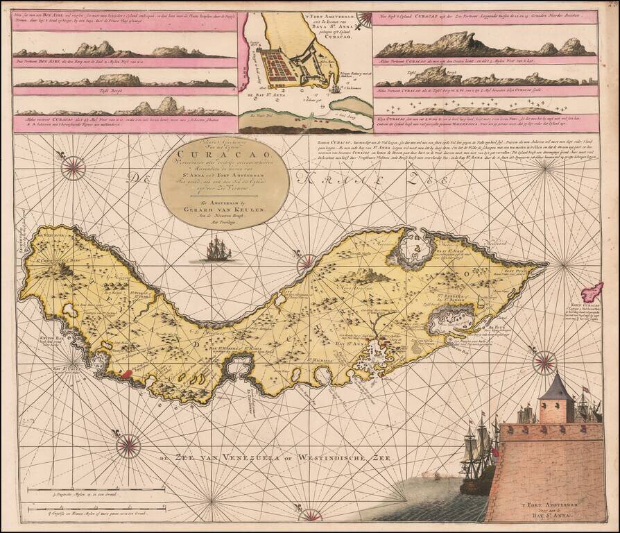
Rare Dutch sea chart of Curaçao, published by the Van Keulen family in the middle of the 18th Century.
The chart includes several coastal insets and an inset of Fort Amsterdam and the Bay of St. Anna.
Van Keulen's chart is one of the earliest detailed maps of Curacao. Based on Arent Roggeveen's map of the island first published in 1675, Van Keulen closely copied a vignette featuring Fort Amsterdam as well as an inset map with a bird's-eye plan of Fort Amsterdam and the Santa Anna Bay. Van Keulen significantly improves upon and updates Roggeveen's chart with numerous details along the coastline and the interior of the island. Navigational notes surround Curacao, with additional notations regarding the locations of salt pans, plantations, and landings by the French.
The island of Curacao was the historical nexus of the Dutch Antilles. With its large and protected natural port, the island was the major center for commerce of the Dutch West India Company. Although first inhabited by the Spanish around 1500, they soon abandoned the island due to its lack of gold and fresh water. In 1634 the Dutch claimed Curacao and began building settlements and plantations.
Van Keulen's chart of Curacao was by far the most accurate obtainable sea chart of the region during this period. Augmented with sailing directions and six coastal profiles, the quality and detail of the chart reflected the importance of Curacao as a regional center for Dutch trade in the Southern Caribbean and along the coast of Venezuela.
The map would serve as the prototype map for Sayer & Bennett's map of Curacao which appeared in the West India Atlas.
If you are a student, write to us in telegram: @antiquemaps and indicate what material you need and for what work you need a map in high detail. We are ready to provide material on special terms. For students only!


![[Wall Map] West-Indische Paskaert waer in de graden der breedde over weder zyden vande middelyn wassende so vergrooten dat die geproportioneert syn tegen hunne nevenstaende graden de lengde.](/map/small/60169.jpg)