Map size in jpg-format: 4.0095MiB
Click to open in high resolution (open in new tab).
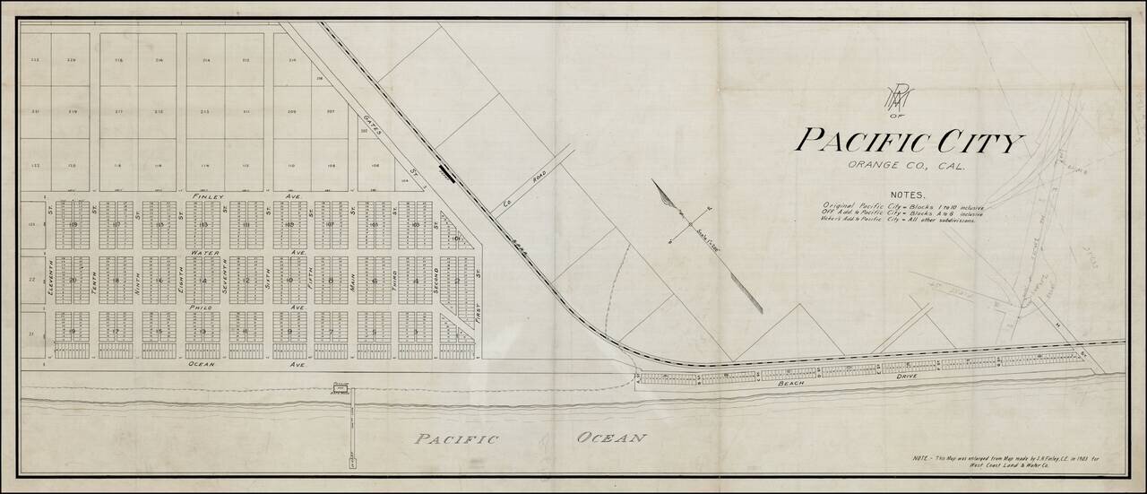
Rare Pacific Electric Railway working map of Pacific City, the first name used for the community which is now Huntington Beach, California, prior to its incorporation in 1909.
The map is enlarged from the map made by S.H. Finley, Civil Engineer, in 1903, for the West Coast Land Company. We date the map based upon the fact that the name has not yet been changed to Huntington Beach, following its sale to Henry E. Huntington in 1903. The map would have been prepared in connection with Huntington's Pacific Electric Railway extending the Red Car Line to Huntington Beach.
The map shows the original Pacific City and the first two additions, Off Addition and Vicker's Addition. Also shown is the Southern Pacific Railroad Line and Depot, the Pavillion, Bathhouse and Wharf, and a street plan, along with manuscript additions in the south. First Street through Eleventh Street remain unchanged, but all the north-south street names have been changed.
In July 1901 Col. R.J. Northam sold his 1,600-acre Bolsa Chica Ranch to a syndicate called the West Coast Land & Water Company for $100,000. The company was composed of Los Angeles and Santa Ana businessmen headed by P.A. Stanton. The syndicate started laying out a new town on the ocean front about five miles above Newport Beach. They first planned to call their new town Bolsa Beach and if the Post Office Department did not accept that name then "Superior Beach" would be proposed. However, when the tract map was filed with the county, the final name chosen was Pacific City.
Development of Pacific City was slow. By early 1903 about 200 lots had been sold, a 550-foot wharf had been built plus a pavilion and about 35 cottages. In May 1903 the Land and Water Company sold their interest in Pacific City to Henry E. Huntington and when a post office was applied for in June 1903 the name of the town was changed to Huntington Beach.
If you are a student, write to us in telegram: @antiquemaps and indicate what material you need and for what work you need a map in high detail. We are ready to provide material on special terms. For students only!


