logo

1914. Map of Los Angeles & Orange Counties Cal. . . 1914

  • Map of Los Angeles & Orange Counties Cal.  . . 1914

Map of Los Angeles & Orange Counties Cal. . . 1914 information:

Year of creation: 
Resolution size (pixels): 
 17825x16455 px
Disk Size: 
 45.5859MiB
Number of pages: 
 1
Place: 
 Los Angeles
Author: 

Print information. Print size (Width x height in inches):
Printing at 72 dpi 
  247.57 х 228.54
Printing at 150 dpi 
 118.83 х 109.7
Printing at 300 dpi 
 59.42 х 54.85

An example of detailing the file of this map of in a printable high-resolution:

Click to open in high resolution (open in new tab).
Attention! this is just the central piece (central area 960x960 px) of the map file!
This is an example, so that you can see and study the level of detail of a given map. The entire Map will be fully available after payment!

Map of Los Angeles & Orange Counties Cal.  . . 1914

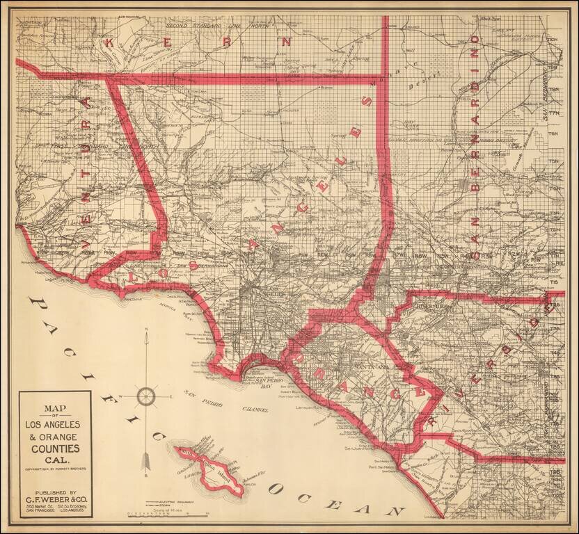
Highly detailed map of Los Angeles and Orange Counties, published by C.F. Weber.

The map shows early railroads, roads, wagon roads, mines, lakes, mills, and many other details.

A number of early ranchos are shown. There is additional detail of surrounding counties including Ventura, Kern, San Bernardino and Riverside.

One of the earliest obtainable separately issued maps of Orange County, which was formed in 1889.


Special conditions for students!

If you are a student, write to us in telegram: @antiquemaps and indicate what material you need and for what work you need a map in high detail. We are ready to provide material on special terms. For students only!

Item information:

Year of creation:
Size:
17825x16455 px
Disk:
45.5859MiB
Number of pages:
1
Place:
Los Angeles
Author:
Punnett Brothers.
$14.99

Related item