logo

1721. Italy. Distinguished according to the Extent of all the States, Kindomes, Republickes, Dukedomes, Principalities &c. that do at present divide it. Most Humbly Inscribed to the Right Honble. the Earl of Stafford . . . 1719

  • Italy.  Distinguished according to the Extent of all the States, Kindomes, Republickes, Dukedomes, Principalities &c. that do at present divide it.  Most Humbly Inscribed to the Right Honble. the Earl of Stafford . . . 1719

Italy. Distinguished according to the Extent of all the States, Kindomes, Republickes, Dukedomes, Principalities &c. that do at present divide it. Most Humbly Inscribed to the Right Honble. the Earl of Stafford . . . 1719 information:

Year of creation: 
Resolution size (pixels): 
 2299x2014 px
Disk Size: 
 1.49145MiB
Number of pages: 
 1
Place: 
 London
Author: 

Print information. Print size (Width x height in inches):
Printing at 72 dpi 
  31.93 х 27.97
Printing at 150 dpi 
 15.33 х 13.43
Printing at 300 dpi 
 7.66 х 6.71

An example of detailing the file of this map of in a printable high-resolution:

Click to open in high resolution (open in new tab).
Attention! this is just the central piece (central area 960x960 px) of the map file!
This is an example, so that you can see and study the level of detail of a given map. The entire Map will be fully available after payment!

Italy.  Distinguished according to the Extent of all the States, Kindomes, Republickes, Dukedomes, Principalities &c. that do at present divide it.  Most Humbly Inscribed to the Right Honble. the Earl of Stafford . . . 1719

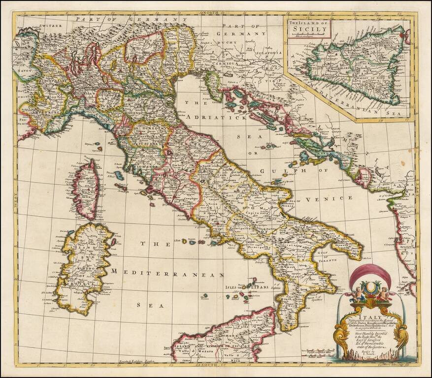
Striking and highly detailed map of Italy, divided into its various regions, from Senex's General Atlas.

Includes decorative cartouche and a large inset of Sicily, with dedication to the Earl of Stafford, Knight of the Order of the Garter.

John Senex (1678-1740) was one of the foremost mapmakers in England in the early eighteenth century. He was also a surveyor, globemaker, and geographer. As a young man, he was apprenticed to Robert Clavell, a bookseller. He worked with several mapmakers over the course of his career, including Jeremiah Seller and Charles Price. In 1728, Senex was elected as a Fellow of the Royal Society, a rarity for mapmakers. The Fellowship reflects his career-long association as engraver to the Society and publisher of maps by Edmund Halley, among other luminaries. He is best known for his English Atlas (1714), which remained in print until the 1760s. After his death in 1740 his widow, Mary, carried on the business until 1755. Thereafter, his stock was acquired by William Herbert and Robert Sayer (maps) and James Ferguson (globes).


Special conditions for students!

If you are a student, write to us in telegram: @antiquemaps and indicate what material you need and for what work you need a map in high detail. We are ready to provide material on special terms. For students only!

Item information:

Year of creation:
Size:
2299x2014 px
Disk:
1.49145MiB
Number of pages:
1
Place:
London
Author:
John Senex.
$14.99

Related item