logo

1903. (Hawaii & Puerto Rico) Lighthouse Chart of the Hawaiian Islands (and) Third L.H. District West Indies between Mona and Virgin Passages, comprising Porto Rico and Dependencies.

  • (Hawaii & Puerto Rico)  Lighthouse Chart of the Hawaiian Islands (and) Third L.H. District West Indies between Mona and Virgin Passages, comprising Porto Rico and Dependencies.

(Hawaii & Puerto Rico) Lighthouse Chart of the Hawaiian Islands (and) Third L.H. District West Indies between Mona and Virgin Passages, comprising Porto Rico and Dependencies. information:

Year of creation: 
Resolution size (pixels): 
 1612x1931 px
Disk Size: 
 600761B
Number of pages: 
 1
Place: 
 Washington
Author: 

Print information. Print size (Width x height in inches):
Printing at 72 dpi 
  22.39 х 26.82
Printing at 150 dpi 
 10.75 х 12.87
Printing at 300 dpi 
 5.37 х 6.44

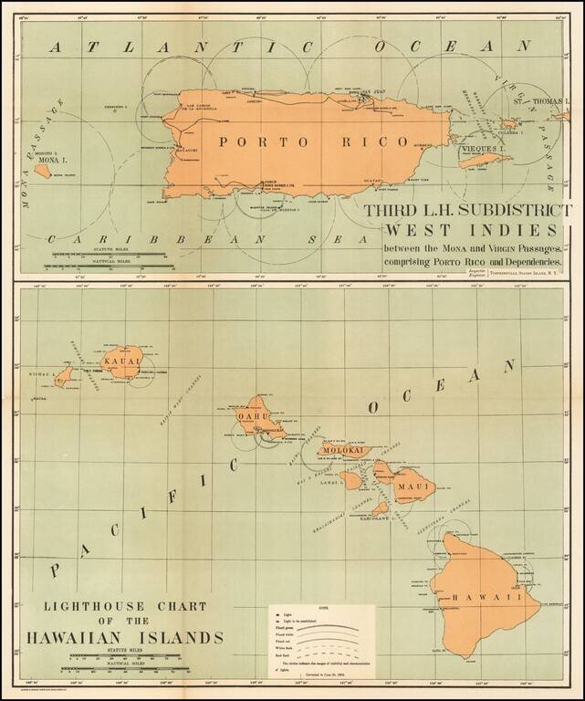
Rare pair of maps showing the lighthouses in Hawaii and the Puerto Rico areas, including proposed light houses, fog lights, light vessels, lighted buoys and a host of other navigational details within the state.

This is the first time we have ever seen this map.


Special conditions for students!

If you are a student, write to us in telegram: @antiquemaps and indicate what material you need and for what work you need a map in high detail. We are ready to provide material on special terms. For students only!

Item information:

Year of creation:
Size:
1612x1931 px
Disk:
600761B
Number of pages:
1
Place:
Washington
Author:
Andrew B. Graham.
$9.99

Related item