Map size in jpg-format: 4.04791MiB
Click to open in high resolution (open in new tab).
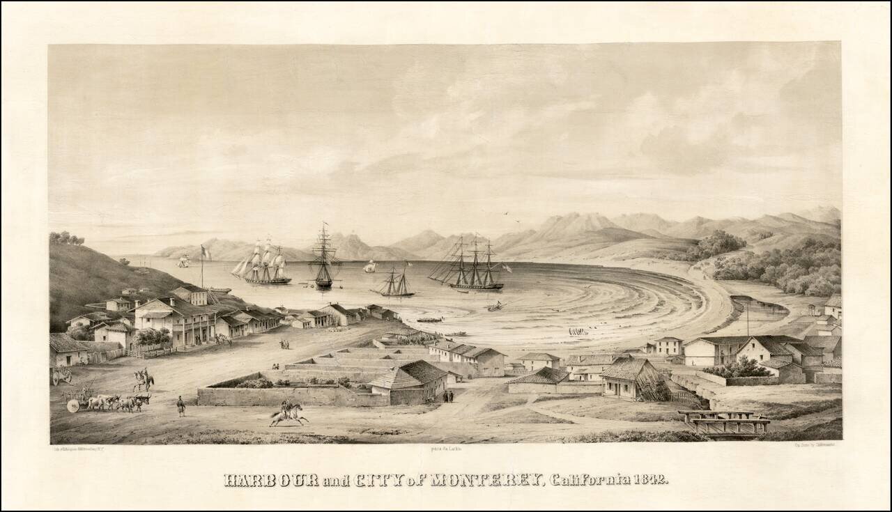
Monterey -- Mexican Capital of Alta California
Nice example of one of the earliest bird's-eye views of California, published by Charles Gildemeister, and printed by D'Avignon in New York, for Thomas O. Larkin.
The view depicts Monterey at the height of its importance as the Mexican Capital of Alta California. Taken from a finely executed series of sketches (possibly by Edward Vischer, one of California's most important early artists, who first came to Monterey in 1842), the view provides a remarkable early record of the town and Harbor at the time the United States established a foreign consulate in Monterey. Thomas Larkin was appointed the first and only American Consul to California. His home, located at Pacific and Jefferson Street, is the origin for the architectural style renowned as "Monterey Colonial."
The map depicts a number of important monuments, including Larkin's home (center left, two stories) and the Customs House, the oldest surviving public building in California and Cooper Molera Adobe.
Creation of the View
While there are two theories on the reason for the creation of the view, the consensus is that the view is based upon original sketches done in 1842, the year which the US opened its California Consul and Thomas Larkin built his home. Given the scene in the harbor, we believe both stories can be seen as correct, as they fit within the same historical framework.
Shortly after creation of the American Consulate, the United States Navy and Marine Corps briefly captured Monterey. After hearing false news that war had broken out between the United States and Mexico, the commander of the Pacific Squadron Thomas Catesby Jones sailed from Lima, Peru with three warships to Monterey, California. The Americans' objective was to take control of the capital city before a suspected British cession could be achieved.
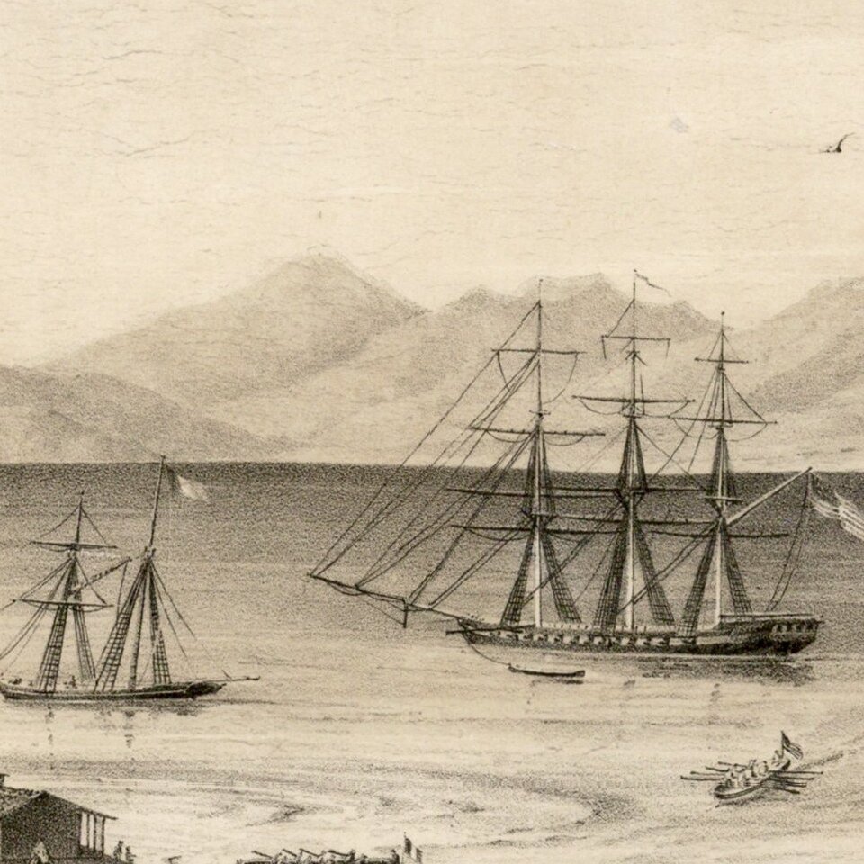
American forces included the frigate USS United States and the two sloops-of-war USS Dale and USS Cyane. The squadron arrived in Monterey Bay on October 19 and anchored. Commodore Jones sent his second-in-command, Captain James Armstrong, ashore to demand a Mexican surrender by 9:00 a.m. the following morning. The Mexican garrison consisted of only 58 men in an old fort. Since they chose not to resist when 9:00 a.m. came, 50 American marines and 100 sailors landed and captured the city without incident.
The next day, Jones learned that war had not begun between the United States and Mexico and that the British were not preparing to take control of California. The Mexican troops were freed and, the landing party boarded their ships and set sail, saluting the Mexican flag as it exited the harbor.
The view depicts 3 American warships in the harbor, along with several smaller vessels. Two rowboats are also shown, each bearing a national flag (Mexico and the US). Circumstantially, this is consistent with the the theory that the view shows the American capture of Monterey in 1842.
The following articuluates the two schools of thought as to the creation of the view. In California on Stone, Harry Peters, who notes:
On October 19, 1842, the surrender of Monterey was demanded by Commodore Thomas C. Jones, commander of the Pacific Fleet. The American flag flew over the plaza for several days before Jones realized his mistake, lowered the flag, and withdrew. One of Jones' officers made a sketch of Monterey at this time, which was later lithographed and sent to Thomas Larkin, an American of some importance then living in Monterey. This was undoubtedly the D'Avignon lithograph.A slightly different account of the creation of the print is given in the Museum and On-Line Archive of the State of California, which notes:
Thomas Larkin, later United States Consul commissioned drawings of the settlement in 1842 and later published them at his own expense in 1850. The quality of this drawing is excellent and may be attributed to Edward Vischer who was then living in Monterey.In Monterey's Waterfront, the authors expand on the above, stating:
Monterey's first and only American Consul, Thomas Larkin, commissioned this pictorial map depicting early Monterey. Larkin had the drawing done to show off his new home, seen in the middle at left. Note that prior to Larkin's wharf of 1845, both passengers and cargo were rowed by boat to shore near the Custom House.The view shows Monterey Bay with houses (some with yards enclosed by stucco walls) and columned portico buildings. There are people on the dirt streets, some riding horses, oxen-drawn cart at left, solid wooden bridge at right. Sailing ships and row boats on Bay, low hills in background.
Peters notes that D'Avignon was at the 323 Broadway address in 1849. Reps list two editions of the view, with slightly different titles and slightly different sizes.
Rarity
Because of its historical importance, several examples of the view are known in public collections. However, in modern times, the view has become virtually unobtainable, with the last reported sale at auction coming in 1975 (Sotheby Park Bernet), where a folded example of the view brought $1,000.
If you are a student, write to us in telegram: @antiquemaps and indicate what material you need and for what work you need a map in high detail. We are ready to provide material on special terms. For students only!