Map size in jpg-format: 14.74MiB
Click to open in high resolution (open in new tab).

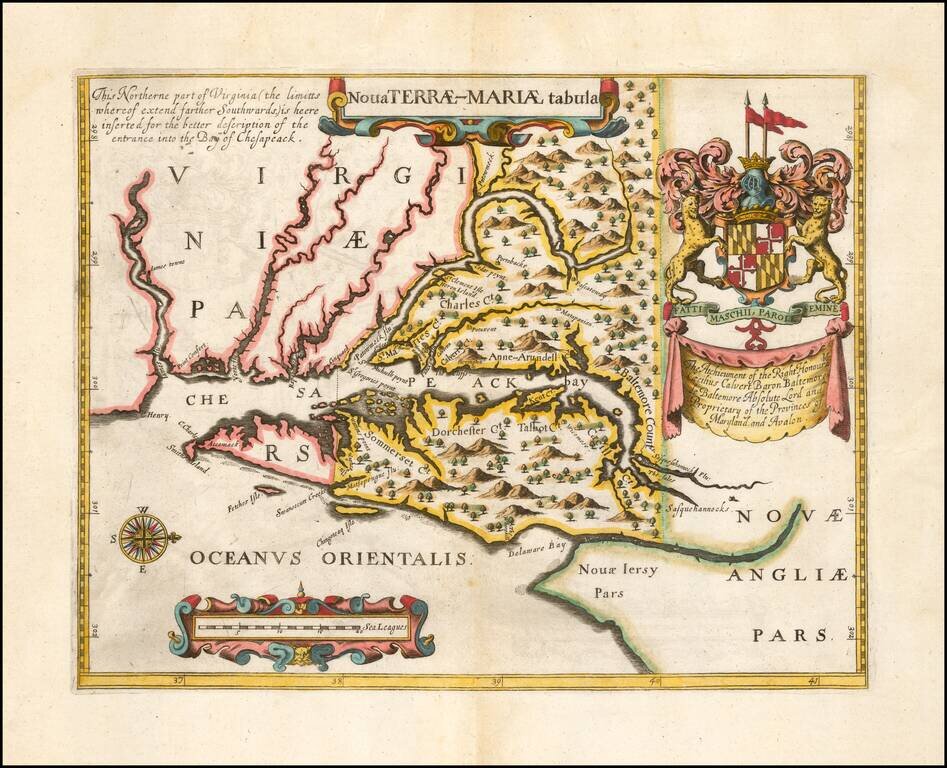
Second Edition of the First Map of the Province of Maryland -- Prepared To Promote The Newly Created Province
Fine example of John Ogilby's rare Lord Baltimore Map, the second edition of the first printed map of Maryland and the first to show the bounds of the newly created province.
The map is drawn largely from John Smith's and Cyprian Thorowgood's explorations. Papenfuse speculated that the map may have been prepared by two members of the first expedition to the New Colony Jerome Hawley and John Lewger, but the maker remains unknown. As noted in the on line description of the map by the Museum of Early Southern Decorative Arts:
In 1632, Charles I granted a charter to Cecil Calvert, Lord Baltimore, for the province of Maryland, and by the summer of 1634, the Calverts had established their first colony. The colony was so prosperous that, according to Papenfuse and Coale in their “Atlas of Historical Maps of Maryland, 1608-1908,” more than 25,000 people left England between 1634 and 1681 for Maryland alone.
This map, published by John Ogilby in 1671 is essentially a second edition of a map bearing the same title, published in 1635 to accompany a promotional tract for the Colony of Maryland. Designed to attract potential colonists to the new world, these pamphlets generally describe the richness of the resources and the potential for economic success. Lord Baltimore’s 1635 tract titled A RELATION OF MARYLAND, also provided an inducement to potential colonists by offering 1000 acres to anyone who would transport laborers to the colony. Lord Baltimore further offered 100 acres for each man or woman, 50 for each child and 50 for each servant.
The map published by Lord Baltimore in his promotional tract was the first separate map published of the area. It was designed to illustrate the boundaries as cited in the original Charter. Unfortunately for Lord Baltimore, his map contained errors that would later serve to his detriment. Disputes over the boundaries between Maryland and Pennsylvania lasted virtually from the time that William Penn received his land grant in 1680 until the Mason Dixon line was run in the 1760s.
In the earlier version of the map (1635) . . . , the 40th degree of north latitude was incorrectly drawn to include just part of the head of the Chesapeake Bay. By the publication of Ogilby’s version of the map, the dotted line marking the northern boundary of the colony had been cleverly changed to include an additional two rows of trees within Maryland’s bounds, thus extending the border northward.
One of the issues in the dispute between the Penn family and Lord Baltimore was whether the Maryland border should be at the 40th degree of latitude as accurately surveyed or at the latitude where it was thought to have been when Lord Baltimore received his grant. Lord Baltimore’s own erroneous map was eventually used by the Penn family as evidence to illustrate that Pennsylvania’s boundary should be farther south.
The banner beneath the upper right coat of arms reads: “The Atchieument of the Right Honoura.ble/ Cæcilius Calvert Baron Baltemore/ de Baltemore Absolute Lord and/ Proprietary of the Provinces of Maryland, and Avalon.”
Ogilby's Second Edition
The second edition of the map, offered here, was prepared by John Ogilby, to illustrate his tract on Maryland to accompany his America of 1671. Papenfuse notes that Ogilby "undoubtedly had assistance from Lord Baltimore and in fact seems to have known about the creation of Cecil County before it was legally recognized by Maryland. . . Lord Baltimore did not create Cecil County until 1674; yet it is to be found both in Ogilby's text and on his map . . . "
An essential map for Maryland collectors.
If you are a student, write to us in telegram: @antiquemaps and indicate what material you need and for what work you need a map in high detail. We are ready to provide material on special terms. For students only!